Rest of the work week: Turning up the heat
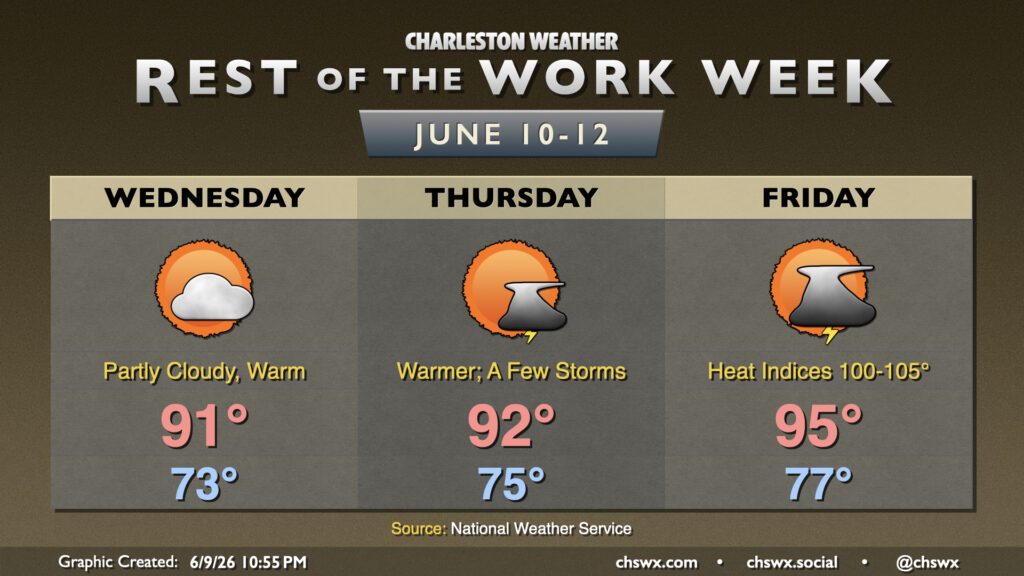
Heat and humidity will continue to build as we head down the home stretch of the work week. We’ll also start to see an uptick in shower and thunderstorm chances as well, which should bring at least a little relief.
High pressure remains the primary weather driver at the surface and aloft, helping temperatures head back into the low 90s in the afternoon and keeping the risk for popup storms to a minimum (though they can never be totally ruled out at this point in the year). Winds will be light and dewpoints will be elevated, so that low 90s air temperature may feel more like the mid-90s.
On Thursday, highs top out in the low 90s after a muggy mid-70s start. Factor in the humidity and it will feel closer to the upper 90s. Ridging loses a little influence, though, and this should mean a bit more in the way of afternoon thunderstorms as the seabreeze pushes inland (with the caveat that coverage should be generally isolated to scattered). If storms fire, they could come with some gusty winds, though the overall severe risk appears low.
Temperatures take another jump Friday as another front approaches the area but doesn’t quite make it. Highs peak in the mid-90s with 70s dewpoints solidly in place, driving heat indices over 100° across much of the area in the afternoon. We should see another round of afternoon thunderstorms as well, with some gusty winds not out of the picture with any storms that form. (Perfectly normal for this time of year, though.)
Follow my Charleston Weather updates on Mastodon, Bluesky, Instagram, Facebook, or directly in a feed reader. Do you like what you see here? Please consider supporting my independent, hype-averse weather journalism and become a supporter on Patreon for a broader look at all things #chswx!