Thursday: Getting warmer — and there’s more where that came from
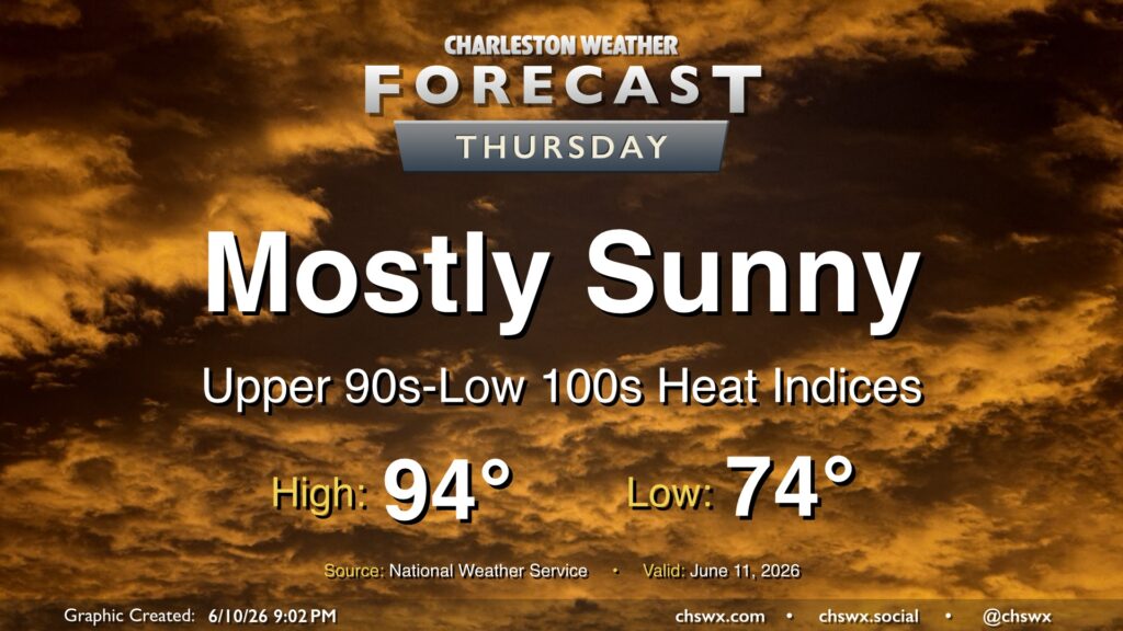
High pressure remains in control across the area, limiting afternoon thunderstorms and allowing heat to continue to build on Thursday. We’ll start in the mid-70s, warming to the mid-90s in the afternoon. Mix in dewpoints in the low-to-mid-70s and that will yield heat indices approaching or even slightly exceeding 100°. And while a brief popup sbower is never fully out of the question this time of year, the vast majority of us will stay rain-free.
Friday & the weekend: Hottest stretch thus far this year; heat advisories possible
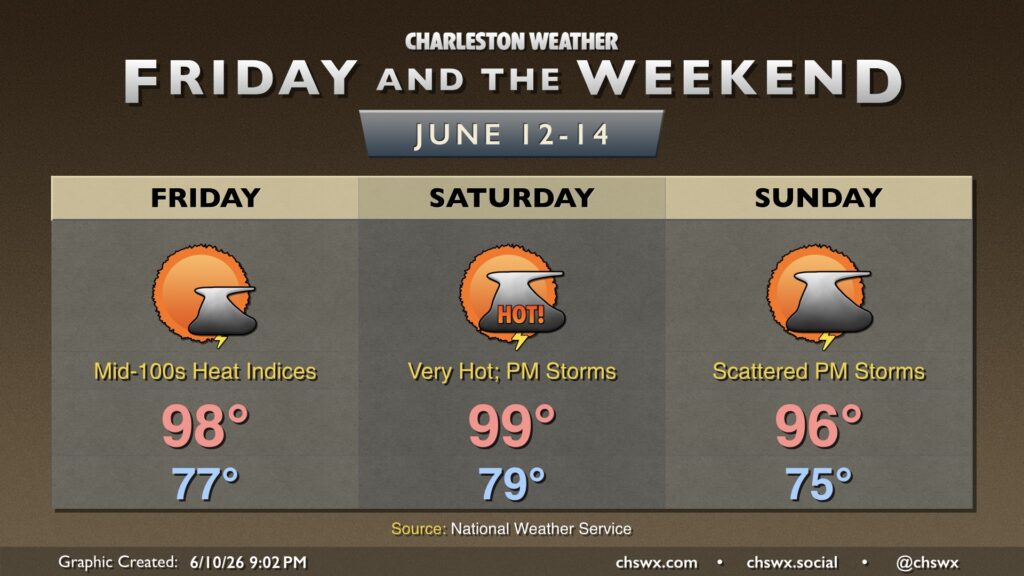
The hottest stretch of 2026 (thus far, anyway) begins Friday and lasts into the weekend, with Heat Advisory-level apparent temperatures likely particularly Friday and Saturday. Friday starts in the mid-to-upper 70s, with lows barely clearing 80° downtown. From there, air temperatures soar into the upper 90s, and factoring in low-to-mid-70s dewpoints, heat indices will climb well into the 100s, and a Heat Advisory is well within the realm of possibility. It’s worth noting that Friday’s forecast high of 98° would break the record high of 97° set in 2016, and that the normal high for this point in the year is closer to 88°.
The warmth peaks Saturday, and it’s nasty — lows likely won’t drop below 80° downtown, and further inland we may not do much better. From there, highs soar into the upper 90s, and a 100° reading or two isn’t out of bounds, either. The current forecast high of 99° at the airport would tie the record high for the date set in 2011. Dewpoints remain very rich, and that should push heat indices solidly into Heat Advisory territory, with upper 100s to low 110s possible. Once again, isolated to widely scattered showers and thunderstorms will be possible in the afternoon and evening as the seabreeze makes its inland trek, but most of us won’t feel much if any relief from the heat.
As a refresher (or perhaps the opposite of one), Heat Advisories are issued by the National Weather Service in Charleston when heat indices are expected to peak between 108-113° for two or more consecutive hours. (Anything higher than that prompts an Extreme Heat Warning.)
An approaching front will bring about a bit more in the way of shower and thunderstorm activity for Sunday, though it’s still probable that a lot of us get the day in rain-free. The increase in cloud cover will help knock temperatures down a couple degrees, but it’ll still be quite abnormally warm with highs peaking well into the mid-90s in the afternoon after a mid-70s start. The record high of 99° for the date, set in 2010, should remain safe. However, mid-70s dewpoints will still help drive heat indices well into the 100s, perhaps falling just short of advisory criteria.
Stay cool this weekend and take it easy if you must be outdoors, especially during the peak heating hours. Get plenty of water and shade, and be sure to look before you lock — hot car deaths for young children or animals are unfortunately a very real and very scary thing, and one of these is too many.
Follow my Charleston Weather updates on Mastodon, Bluesky, Instagram, Facebook, or directly in a feed reader. Do you like what you see here? Please consider supporting my independent, hype-averse weather journalism and become a supporter on Patreon for a broader look at all things #chswx!