Rest of the work week: Dangerous heat builds
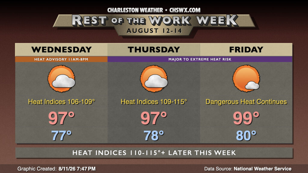
The weather story for the rest of the work week will be the intensifying heat wave across the area as high pressure building in aloft continues to strengthen, while southwesterly winds continue to pump in high-dewpoint air that will send heat indices over 110° in spots.
Wednesday will get off to another warm start, with lows only bottoming out in the upper 70s (and perhaps not getting below 80° at the beaches). We’ll then see air temperatures warm well into the 90s in the afternoon, with mid-to-upper 90s common across the area. Dewpoints running in the mid-to-upper 70s will yield heat indices 106-109°, with pockets of 110°+ heat indices possible. The greatest risk for 108°+ heat indices remains in the coastal corridor, so another Heat Advisory will be in effect for Charleston and tidal Berkeley (Daniel Island, Hanahan) counties from 11am-8pm. Thunderstorms appear highly unlikely with strong high pressure in place, but can never be totally ruled out this time of year.
The heat continues to turn up on Thursday and Friday, which may see heat indices reach or even exceed 115° in spots close to the coast. Air temperatures Thursday will reach the upper 90s, while we could flirt with the century mark on Friday. Don’t be surprised to see a series of Extreme Heat Watches or Warnings starting tomorrow. Thunderstorm chances will remain minimal with the ridge of high pressure still in place, though as always, a stray storm is not out of bounds. We’ll also want to monitor thunderstorm complexes rounding the ridge in a “ring of fire” pattern; sometimes these can bring some unexpected unsettled weather in these kinds of patterns.
Tropics: Next Atlantic tropical cyclone looking more likely, but no concerns at home
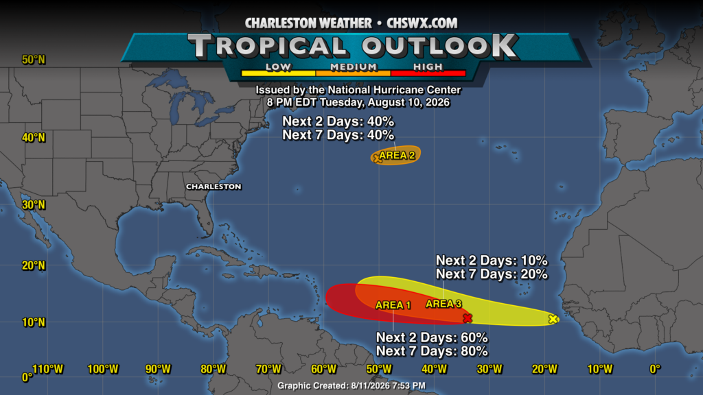
NHC continues to monitor three areas of interest in the Atlantic for possible tropical development. The most likely area of development is found around 35°W and has been designated as Invest 92L. As of the 8PM update from NHC, 92L’s development risk has increased to 60% in the next two days and 80% in the next week. Despite expected development, it certainly seems like 92L will struggle as it heads westward, though tropical storm conditions may become a factor for the Lesser Antilles later this week. Elsewhere, a second wave off Africa has a 20% chance to develop over the next week, while another wave on the north side of Atlantic high pressure has a 40% chance to develop as it moves eastward toward the Azores. All that said, there are no threats to us here at home to speak of. As always, we’ll keep an eye on things as we head closer to the peak of the season.
Follow my Charleston Weather updates on Mastodon, Bluesky, Instagram, Facebook, or directly in a feed reader. Do you like what you see here? Please consider supporting my independent, hype-averse weather journalism and become a supporter on Patreon for a broader look at all things #chswx!