Rest of the work week: Turning cooler — and breezier
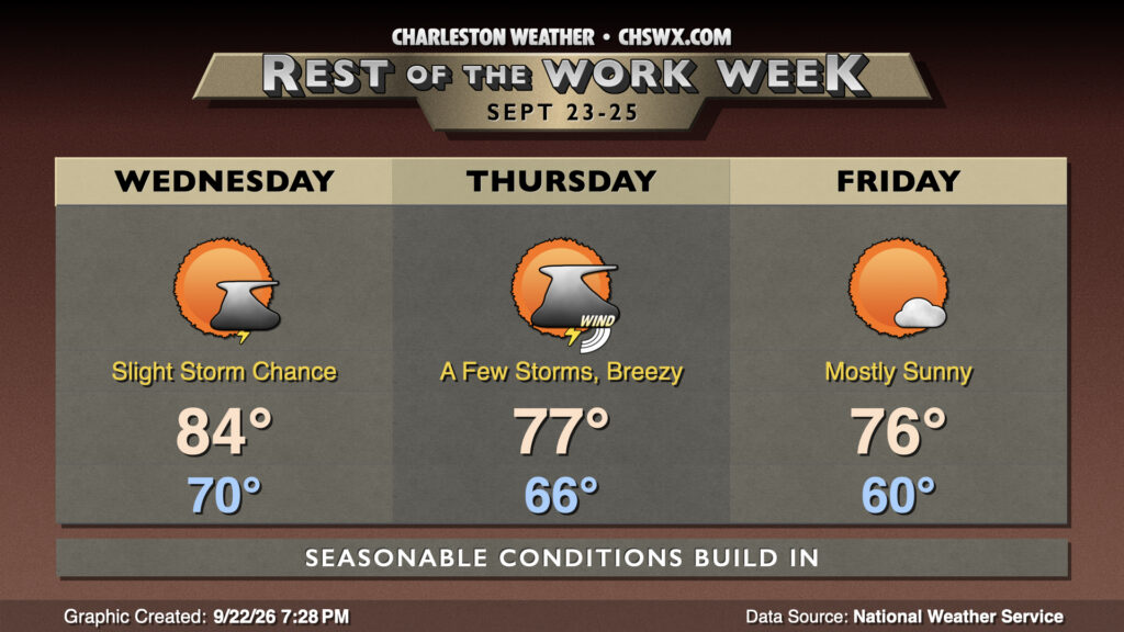
The first legitimate shot of cooler air of the season begins to build in on Wednesday as high pressure starts to wedge into the area from the north. It’ll bring with it some breezy conditions and an elevated risk of coastal flooding that will last into at least Friday.
We’ll still get off to a warm start on Wednesday as the front will just be getting through in the morning, so lows in the 70s still appear probable. However, as the day goes on, northeasterly winds begin to stiffen and become gusty — 20-25 MPH gusts appear possible, especially closer to the coast — and that combined with cloud cover and a few isolated storms will keep temperatures pinned into the mid-80s. The drier air doesn’t really reach the area until later Wednesday into Thursday, so it’ll still feel a bit muggy out.
As low pressure begins to spin up offshore, the pressure gradient will tighten between it to the east and high pressure to the north, bringing about a rather breezy day on Thursday. Gusts 30-35 MPH appear possible, once again with the greatest risk of stiff winds near the coast, so be careful as you drive across the bridges. However, the cooler and drier air will start to arrive, and we’ll start the day in the mid-60s, warming to the mid-to-upper 70s in the afternoon. Shower and thunderstorm chances will run a little higher, especially the further east you are, with the developing low pressure. However, not everyone will see rain.
A really solid stretch of weather then begins on Friday, which looks to be the crispest start to a day since June 5th, when the low temperature reached 60°. Lows could drop into the upper 50s further inland, while low 60s look more likely in the metro area. From there, temperatures will head into the mid-70s under mostly sunny skies as deeper dry air punches in from the north around the backside of the increasingly deep low pressure system off the New England coast. As the low pulls away, the pressure gradient will relax, so we shouldn’t see quite as windy of a day, too. We’ll keep this gorgeous weather in place through the weekend, with a gradual warming trend back to the 80s by early next week.
Coastal flooding possible starting Wednesday through the weekend
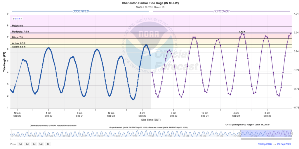
Northeasterly winds and an upcoming full moon will drive an increased risk for coastal flooding around times of high tide beginning Wednesday evening, with the greatest risk for minor to moderate coastal flooding coming with the high tides on Thursday and Friday evenings. Keep an ear out for Coastal Flood Advisories from the National Weather Service, as that will be your signal for an increased risk for flooded and closed roads in downtown Charleston.
Follow my Charleston Weather updates on Mastodon, Bluesky, Instagram, Facebook, or directly in a feed reader. Do you like what you see here? Please consider supporting my independent, hype-averse weather journalism and become a supporter on Patreon for a broader look at all things #chswx!