Next seven days: Unsettled weekend ahead as Isaias passes to the west
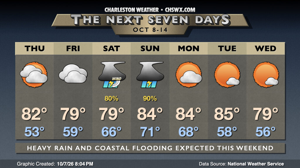
High pressure will wedge southward into the area over the next couple days before being shoved out of the way by Tropical Storm Isaias as it makes landfall on the Gulf Coast on Saturday, bringing about a very unsettled weekend with heavy rain, flooding, and possibly some severe weather.
Editorial note: Daily posts going on hiatus
But first, a quick editorial note. I’ll be going on medical leave for a little while as I recover from a heart procedure I’ll be having tomorrow (Thursday). I’ll be just fine and should be back at full strength before the end of the year, but I’m also not going to take shortcuts in my recovery, either. The timing is definitely not ideal, as you will see in a second, but it is what it is. In the meantime, we’ll be running with some additional automation on social media, and you’ll be able to get the latest NWS forecast automatically from chswx.com. Thank you all for your support, and I’m looking forward to getting back into the forecast feeling better than ever.
Isaias approaching hurricane strength; peripheral impacts expected
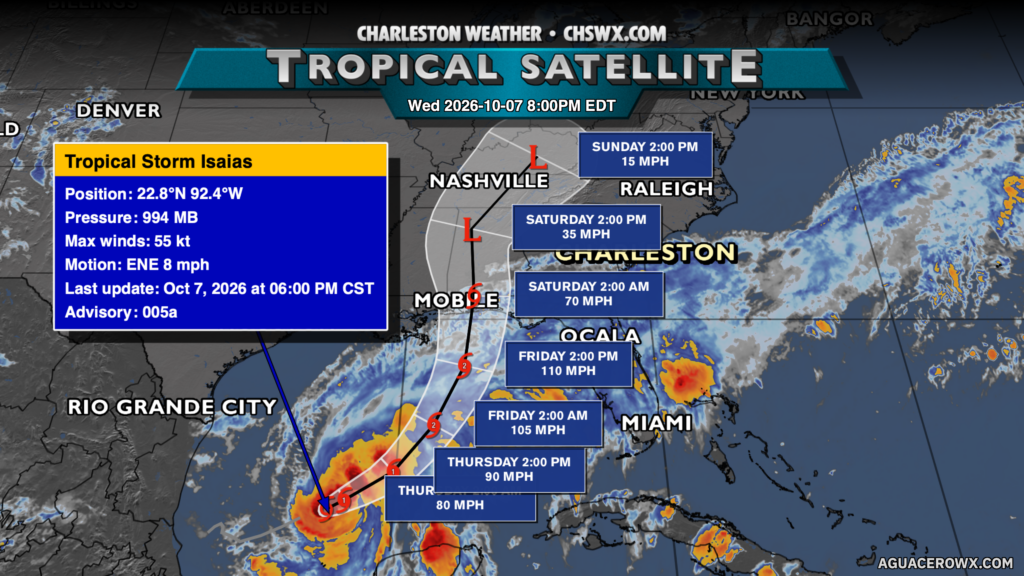
Tropical Storm Isaias is on track to become the season’s first hurricane tonight, with an improving satellite appearance and favorable conditions ahead of it that should allow it to approach major hurricane strength before a landfall somewhere along the central to eastern Gulf Coast this weekend. Direct impacts from Isaias are not expected here, but the large-scale flow around the system will direct plenty of moisture our direction, with a developing pressure gradient bringing breezy conditions and the risk for salt water flooding around times of high tide. Periods of heavy rain appear likely over the weekend, and fresh water flooding due to heavy rainfall is not out of the question, either. As mentioned yesterday, there will also be a sneaky risk for severe weather primarily Saturday into Saturday night as winds veer southeasterly and instability moves in from the Atlantic. Shear profiles continue to look favorable for brief spin-up tornadoes, but the available instability will have a lot to say in that matter. Stay close to trustworthy weather sources as we head into the weekend as there is still a lot of uncertainty.
High pressure will build back in from the west on Monday, clearing things out and turning things a bit unseasonably warm before another front moves by Tuesday, ushering in cooler high pressure that should make for a beautiful Wednesday.
Follow my Charleston Weather updates on Mastodon, Bluesky, Instagram, Facebook, or directly in a feed reader. Do you like what you see here? Please consider supporting my independent, hype-averse weather journalism and become a supporter on Patreon for a broader look at all things #chswx!