Jared Smith founded @chswx on Twitter in 2008 as an experiment in disseminating weather data through social media. In the ensuing decade-and-a-half, @chswx has provided live coverage of tropical cyclones, tornadoes, severe weather, and even a couple bouts of winter weather to the good people of Charleston, SC.
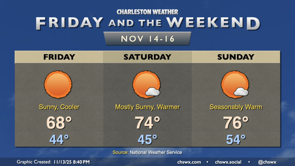
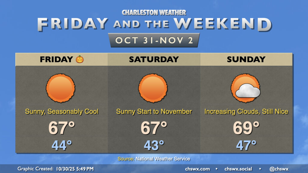
Quiet weather continues for Friday and the weekend as reinforcing high pressure arrives overnight. Friday will feel a touch cooler than Thursday did, with winds going back around to the north in the wake of a dry cold front. Lows Friday bottom out in the mid-40s, with highs peaking in the upper 60s in the afternoon under uninterrupted sunshine.
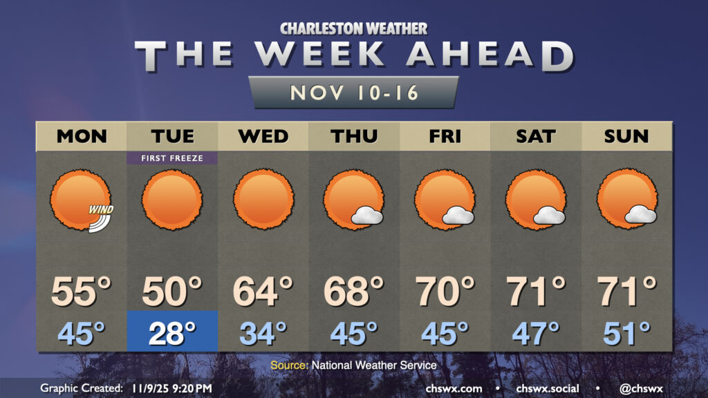
Record lows were tied both at North Charleston as well as Downtown Charleston Tuesday morning as a potent shot of Arctic air swung through the area. The low at the airport fell to 29°, tying the record first set in 1943, while Downtown fell to 32°, tying the record low first set in 1913. A record cold high temperature appears to have been set as well at the airport, with the high only reaching 49° for the day, breaking the record of 54° set in 1968. Downtown also only peaked at 49°, but the record cold high temperature of 46°, set in 1913, remains safe. The freezing temperatures put an end to the growing season, which means that there will be no more Frost and Freeze products from the National Weather Service until the season resumes in March.
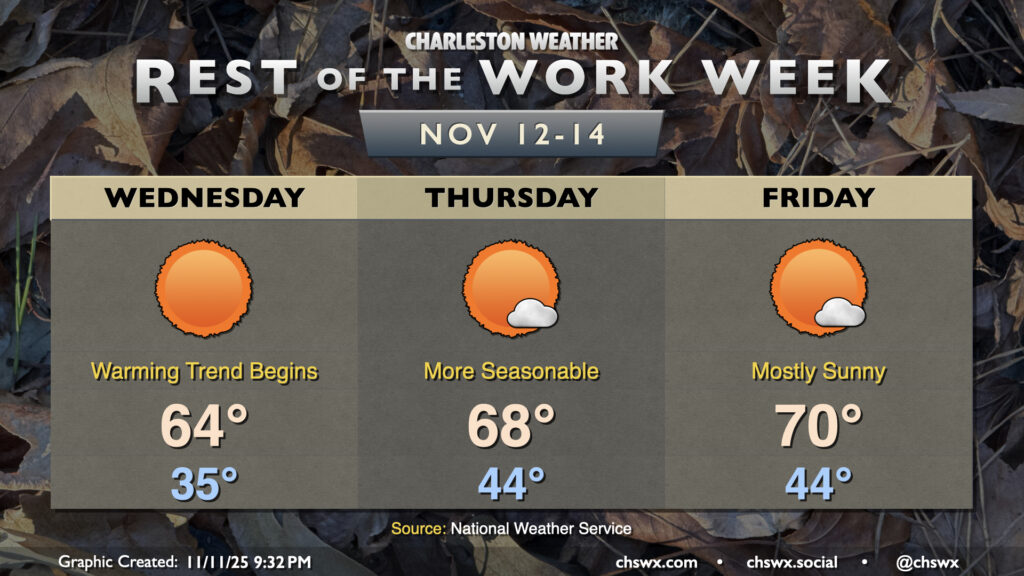
The good news is that a warming trend begins Wednesday. Temperatures will bottom out around or below freezing further inland, but should only drop to about the mid-30s closer to the coast and in the metro area. Temperatures will rebound quite nicely under full sunshine, with highs peaking in the mid-60s in the afternoon. This is still a little off the normal high for this point in November, but only by about 5-6° as opposed to 22°! The warming trend continues Thursday into Friday as the airmass continues to moderate under high pressure, with just a few clouds from time to time. Overall, there continues to be no major weather concern this week now that we have last night’s freeze behind us.
A highly anomalous Arctic intrusion is arriving this evening, evidenced by gusty winds 25-30 MPH and plummeting dewpoints across much of the area as of 7PM Monday. Further north, some flurries were reported in the Charlotte metro area and as far south as Hartsville, SC. Here at home, the first freeze of the season will occur for the vast majority of us; ensure pets and plants are protected and safe tonight as temperatures will fall into the 20s. Wind chills could drop into the upper teens, prompting a Cold Weather Advisory for Dorchester County. (Layer up!) Despite full sunshine, temperatures may not crack 50° in the afternoon, owing to the strength of the Arctic blast. If these forecasts verify, new record low and record cold high temperatures will be set at the airport: the record low for November 11 is 29°, set in 1943, while the record cold high temperature is 54°, set in 1968.
A strong cold front will bring about the first freeze of the season overnight Monday into Tuesday as a highly anomalous intrusion of Arctic air pushes southward. The winter preview will be short-lived, thankfully, but it will be impactful as the growing season almost certainly will end Tuesday morning.
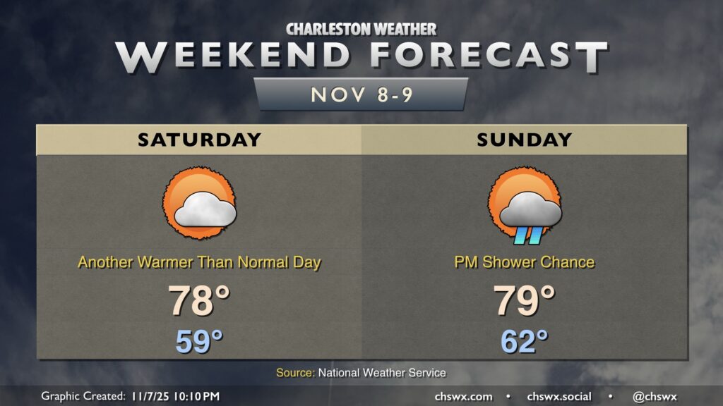
A couple more warm days lie ahead before the coldest airmass of the season crashes into the area next week. Saturday will generally feature temperatures in the upper 70s after starting the day near 60°. We’ll keep a few clouds around, but the risk for any rainfall should be very low.
A strong front approaches the area Sunday, and there’s a chance that some showers and maybe a thunderstorm could move through in advance, but the risk will be diminishing as the front pushes eastward as moisture doesn’t look to be in abundance. Temperatures Sunday peak near 80° after starting in the low 60s.
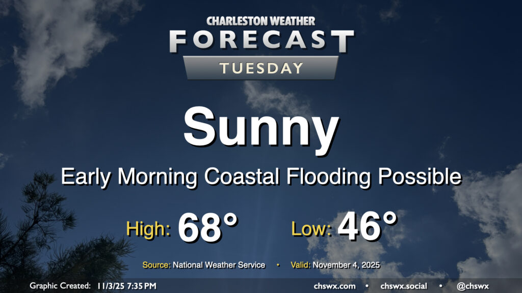
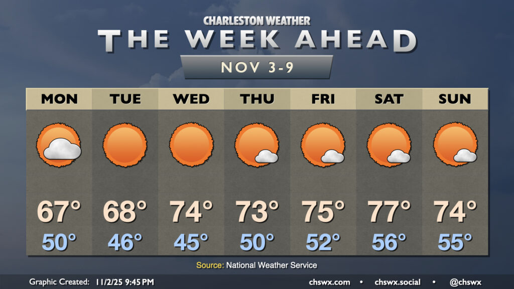
Plenty of sunshine will continue on Tuesday as high pressure builds across the area from the west, keeping northeasterly flow in place which will keep temperatures on the cool side of normal and also help to elevate the morning high tide into minor flood stage. We’ll start the day in the mid-40s, warming to the upper 60s in the afternoon, which will feel quite comfortable with the sun out. The aforementioned northeasterly winds will run generally in the 5-10 MPH range, which will be enough of a breeze to make it feel a little cooler in the shade.
As mentioned, some coastal flooding will be possible between 5-8am as water levels peak in minor flood stage (7-7.2′) with the 6:11 am high tide. This may have limited impacts in the most vulnerable areas of the peninsula, primarily around the Hagood/Fishburne intersection as well as possibly on parts of Lockwood. Be ready to reroute around any closures.
The week ahead looks generally quiet and increasingly warm, especially as we get into late week and the first part of the weekend, but nothing too out of bounds for early November. Coastal flooding will become an issue beginning Tuesday as favorable winds and the highest astronomical tides of the season coincide, though.
November will get off to a sunny and somewhat chilly start as lows head into the low 40s for the first time since late March with clear skies and calmer winds letting things cool off a little more than Thursday night. We’ll then warm to the upper 60s in the afternoon with plenty of sunshine to be had as high pressure slides overhead.
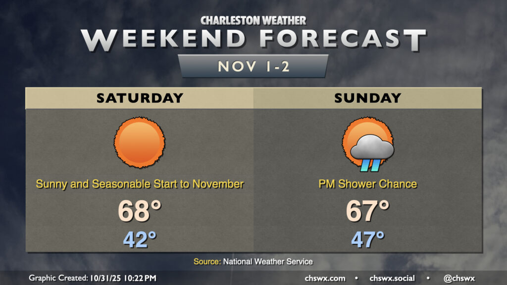
Halloween may be full of frights, but the weather won’t be one of them — seasonable and quiet weather is in store heading into Sunday with high pressure in control. Lows Friday bottom out in the mid-40s in the metro, with perhaps even lower temperatures further inland and in rural areas. We’ll warm to the mid-to-upper 60s in the afternoon with predominantly sunny skies and a gentle breeze out of the west. Saturday is essentially a carbon copy of Friday, though winds will be a little calmer and shifting direction out of the northeast and east. Don’t forget to set your clocks back an hour Saturday night as we fall back to Standard Time.
We’ll start to see dewpoints to climb back up and cloud cover begin to thicken as Sunday goes on in advance of the next storm system advancing out of the Gulf. Rain should hold off for the vast majority of the day, though a shower or two can’t be ruled out in the late evening. Temperatures on Sunday run a little warmer, with lows in the mid-to-upper 40s and highs approaching 70° despite the increasing cloud cover.
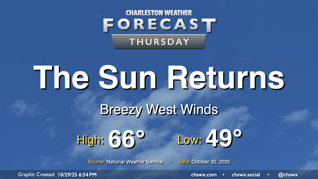
A cold front will swing through overnight, scouring out the clouds and ushering in drier high pressure behind it. It’ll be great to see the sun, which will make highs in the mid-60s feel quite nice. We’ll have a bit of a westerly breeze in the wake of the front, so keep that in mind if you have any plans to dine al fresco, but otherwise, it looks like a really good day of weather across the Lowcountry.