Jared Smith founded @chswx on Twitter in 2008 as an experiment in disseminating weather data through social media. In the ensuing decade-and-a-half, @chswx has provided live coverage of tropical cyclones, tornadoes, severe weather, and even a couple bouts of winter weather to the good people of Charleston, SC.
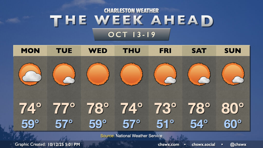
The nor’easter that has made for several soggy days across the metro will finally be pulling away on Monday, yielding a beautiful week of weather across the area with plenty of sun and comfortable temperatures.
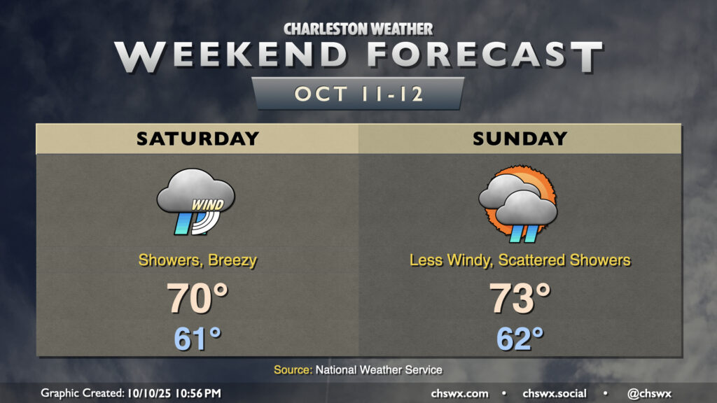
The nor’easter that drove the highest tide of the year on Friday will continue to affect our weather Saturday and to a lesser degree on Sunday. Showers will continue overnight through much of the day on Saturday, and gusts will continue to head into the 25-30 MPH range especially near the coast and on bridges and overpasses. Temperatures remain on the cool side as well, with lows in the low 60s warming to just about 70° at best in the afternoon.
We will also be contending with the risk for moderate coastal flooding once again with the midday high tide. A Coastal Flood Advisory is in effect from 10 AM-2 PM as a result. While this tide will certainly be less severe than we saw on Friday, it’ll still be high enough to close plenty of roads downtown right smack in the middle of the day. Be ready to reroute around road closures as a result.
We’ll see the nor’easter gradually pull away Sunday, though some showers look to persist. Temperatures will still be cooler than normal, with lows in the low 60s warming to the low-to-mid-70s in the afternoon with a little bit more sun breaking through. Winds will be backing off, and this will help mitigate a more serious coastal flooding threat during the day, though we should still see minor to moderate flooding with the early afternoon high tide that could close a few roads.
This will lead into a quieter and sunnier week ahead with high pressure in control. Humidity will be low and temperatures will be comfortably warm, with highs in the upper 70s to around 80° each afternoon.
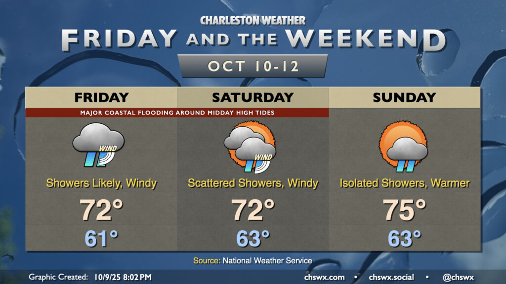
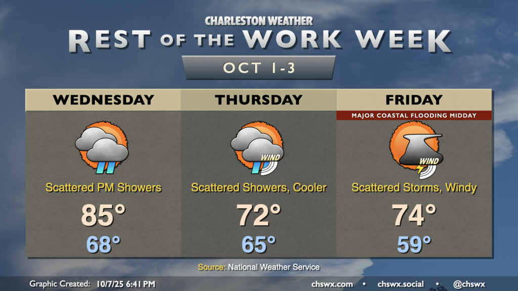
A non-tropical storm system spinning up offshore will bring wind and rain to the area along with major coastal flooding with the midday high tides Friday and Saturday. We’ll start to see some improvements Sunday, thankfully.
A cold front will pass through overnight, bringing with it a chance for showers and maybe even some thunder as it moves by. Behind that front will be a significant airmass change as high pressure builds southwestward into the area. We’ll wake up to lows in the mid-60s, with temperatures climbing just to the mid-70s under mostly cloudy skies. It’s going to be quite breezy, with northeasterly winds gusting 30-35 MPH at times, especially near the coast.
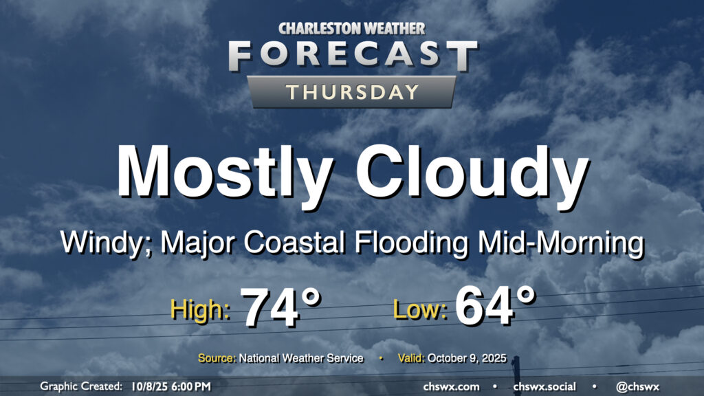
The strong northeasterly winds will drive water levels in the harbor quite high on top of already high astronomical tides, especially during the day on Thursday (and for the next several days). High tide will peak around 10:06 AM around 8-8.2′ MLLW, which is comfortably in the major flooding threshold. A Coastal Flood Watch is in effect and will likely be upgraded to a warning if trends continue overnight. Be ready for numerous road closures in downtown Charleston as well as salt water impingement onto roads on James and Johns Islands as well as Daniel Island. Moderate coastal flooding is expected with the evening high tide as well, with water levels peaking around 7.5-7.7 MLLW between 9 PM and midnight. This should be high enough for another round of road closures downtown, so be mindful if your travels take you there Thursday night.
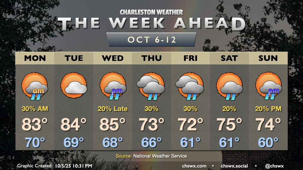
Occasionally unsettled and breezy conditions will continue for the next few days as a front moves through, high pressure builds in, and low pressure spins up offshore.
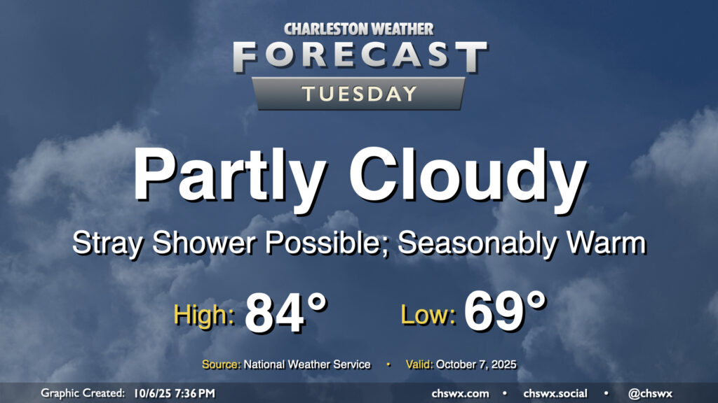
We stay warm on Tuesday with another day of high pressure at the surface and aloft driving temperatures above normal across the area. We’ll start the day near 70°, warming to the mid-80s in the afternoon under partly cloudy to mostly sunny skies. A few showers appear possible near the coast during the morning and early afternoon hours, but otherwise, many of us should get a rain-free day in.
We will need to continue to monitor the risk for coastal flooding around times of high tide, especially during the morning, with minor to moderate coastal flooding likely between 6-11 AM. (High tide peaks around 8:23 AM.) When we get into moderate flood stage, we start to run into more widespread road closures downtown, and given the timing, commute impacts appear likely. Allow extra time to reach your destination if downtown is where you’re headed in the morning. Another round of minor coastal flooding will be possible generally between 7-11 PM, which may yet close a few vulnerable roads but should not get as high as the morning high tide.
Warm temperatures will continue for the first half of the week before a cold front knocks temperatures down below normal starting Thursday. Shower chances will be with us for much of the week, though, and we’ll be dealing with coastal flooding as well.
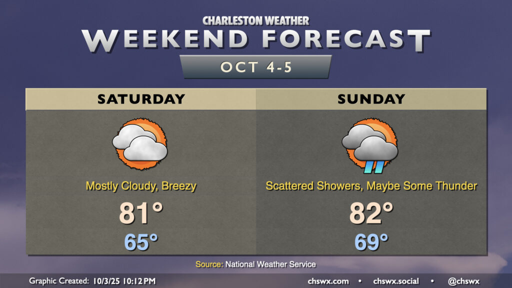
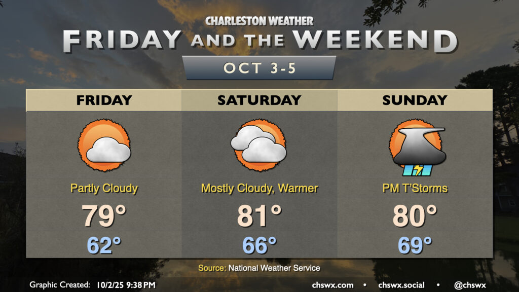
A decent weekend of weather awaits. While Saturday is the pick day of the weekend, if you are okay with dodging some showers, Sunday doesn’t look terrible, either. Generally speaking, we can expect highs in the low 80s each afternoon after lows in the mid-60s on Saturday and upper 60s to around 70° on Sunday. Breezy northeasterly to easterly winds will continue with high pressure still wedged southward across the area, though that high will begin to give way on Sunday and send rain chances up a little bit as a result. Can’t rule out some thunder, either, though that looks relatively unlikely.
We will need to watch times of high tide for minor to moderate coastal flooding as we approach the full moon next week. The continued onshore flow will help to drive water levels higher on top of already high astronomical tides, which should reach heights that will close some roads downtown. Be alert for possible Coastal Flood Advisories from the National Weather Service.
Temperatures will continue to be generally seasonable if not slightly cooler than normal for Friday and the weekend as high pressure continues to wedge southward into the area, though we will see an uptick in moisture and, eventually, rain chances heading into Sunday.
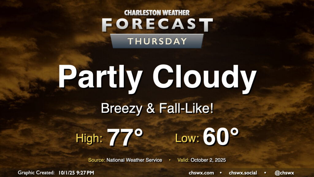
Thursday will give us a really nice taste of fall as cool high pressure wedges southward into the area. We’ll start the day with temperatures around 60°, warming to just the mid-70s under partly cloudy to mostly sunny skies. The northeasterly breeze will still be somewhat elevated, which may contribute to some minor tidal flooding around the 4:45 PM high tide. Otherwise, it’ll be an enjoyable day to get outside and touch some grass.