Jared Smith founded @chswx on Twitter in 2008 as an experiment in disseminating weather data through social media. In the ensuing decade-and-a-half, @chswx has provided live coverage of tropical cyclones, tornadoes, severe weather, and even a couple bouts of winter weather to the good people of Charleston, SC.
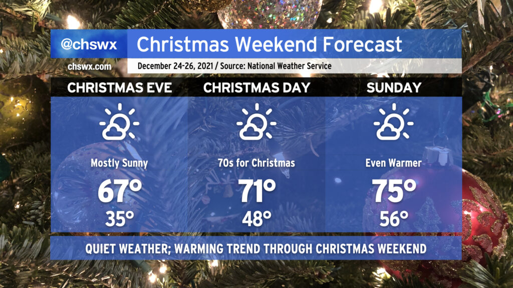
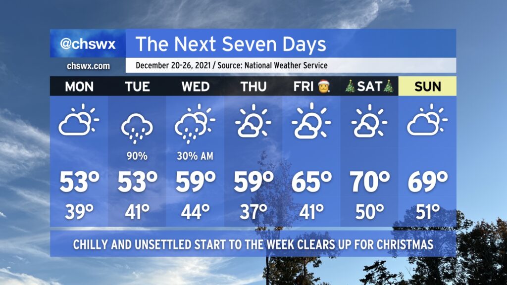
We head into Christmas weekend with mostly quiet weather on tap as high pressure remains in command. After another chilly start Friday morning, we will warm into the upper 60s for the afternoon, some 10°+ warmer than what many spots experienced today.
No impediments to sleigh aviation are expected overnight Friday into Christmas morning, which is good news all around. Temperatures will bottom out about 10° warmer on Christmas morning than we will see on Friday in the upper 40s to perhaps low 50s near the coast. Highs in the low 70s will be common on Christmas Day as our warming trend continues, and we turn even warmer on Sunday as highs top out in the mid-70s after starting the day with lows that will run closer to normal highs for this point in the year.
Overall, though, no weather worries for this holiday weekend. Enjoy, be safe, and if you’re celebrating, have a very merry Christmas!
A reinforcing cold front will drop through the area tonight, bringing us mostly clear skies overnight and another round of cool air that should help temperatures drop to near freezing in the metro area, and likely right at freezing inland. (We’ll stay a little warmer at the coast.) Make sure pets and plants are in a warm, protected place tonight.
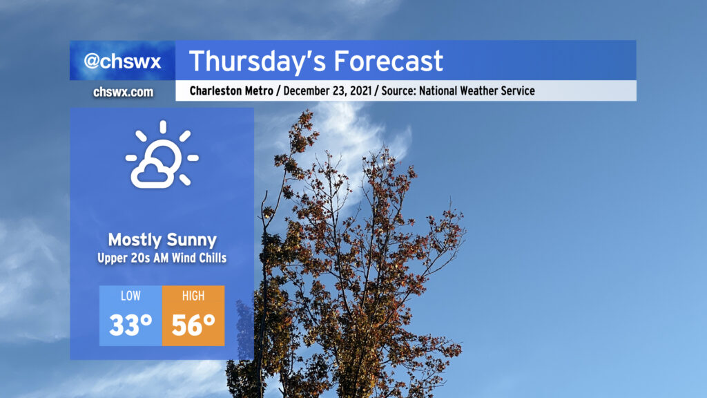
After Thursday, temperatures will warm back into the 60s for Friday and the low 70s for Christmas. We’ll keep fair weather in the forecast through early next week with continued warmer-than-normal temperatures as we approach the end of 2021.
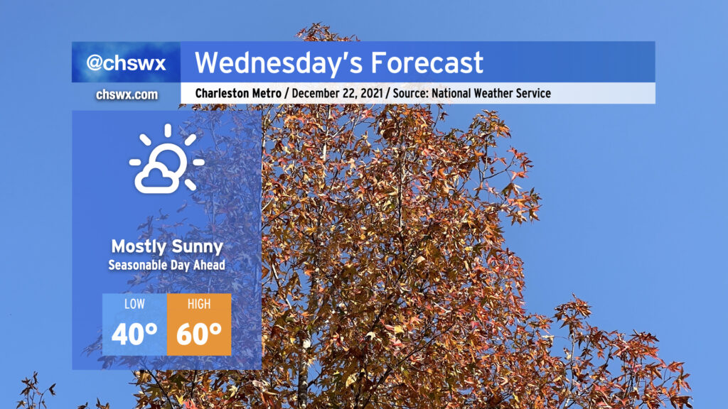
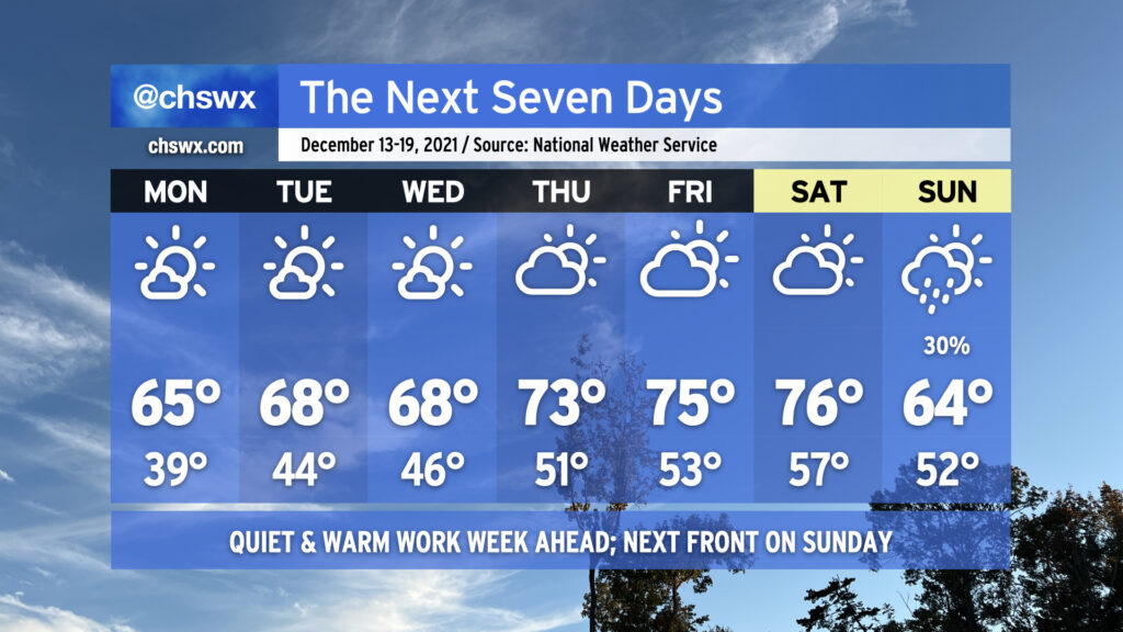
For as cruddy as Tuesday was, Wednesday looks significantly nicer. We’ll keep a late-December feel to the air with highs only getting to about 60° in the afternoon under mostly sunny skies as high pressure builds in from the west. This will begin another rain-free stretch for our area into early next week. High pressure moves to our north and shifts winds around to the northeast for Thursday, keeping us in the 50s despite almost full sunshine. After high pressure moves offshore Friday, we’ll warm up into the 70s for a few days starting on Christmas Day. All in all, looking good for any last-minute gift acquisition.
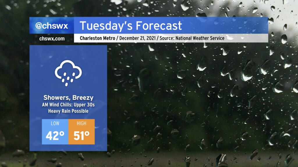
Get ready for an unsettled and chilly Tuesday with rain and breezy northeast winds for much of the day. Rain could start as early as 1-2am, but will peak during the day with up to 1-1.5” possible in spots as low pressure moves northeastward parallel to the coast.
Chilly high pressure will remain wedged into the area through tomorrow, and the interaction between it and the low pressure system will help kick up northeasterly winds, especially at the coast. We could even see some minor salt water flooding with the 9:02am high tide as the wind could push the tidal anomaly close to 7’.
Elsewhere, this wind will make temperatures feel even cooler than they already will be, with wind chills in the 30s possible well into mid-morning. Winds notwithstanding, the forecast high of 51° may very well be optimistic especially given rain falling into the wedge, helping to reinforce the cold air dam across the area.
The good news is that our weather improves beginning Wednesday, and we’ll be on our way to a warming trend with much more sunshine heading into and beyond Christmas.
After a cold front came through and chilled us way out today, we will stay in this chilly pattern for a few more days ahead of a late-week warmup as high pressure wedges into the area. Monday looks to remain dry with peeks of sun amongst the clouds; chilly northeasterly winds will keep highs suppressed in the low 50s. Low 50s may be very optimistic for Tuesday’s highs given the potential for strengthening northeasterly winds and expected rainfall around a low pressure system throughout the day helping to reinforce the cool wedge.
Said storm system departs Wednesday, allowing us to dry out and warm up a little bit with highs near 60° in the afternoon. Even fewer clouds look to be an issue for Thursday as temperatures once again approach 60°.
By Friday, we will be heading into a warming trend that’ll put us in the upper 60s to low 70s for Christmas Day with continued sunny skies. Certainly no concerns for sleigh aviation overnight Friday into Christmas morning on Saturday, which is always welcome news.
Aside from the storm system on Tuesday, we’ll need to watch morning high tides this week for the potential for coastal flooding given the recent full moon and strong northeasterly winds. A major coastal flooding event is not expected, but minor salt water flooding could cause a few roads to take on water. We’ll especially need to watch Tuesday in case heavy rain coincides with high tide. Fortunately, as the pressure gradient near the coast relaxes, so will the coastal flooding threat.
Record high temperatures will be possible Friday and Saturday as deep southerly flow pumps a lot of warm air into the area ahead of a cold front currently timed to get through here on Sunday.
We’ll start Friday with some patches of fog in the area giving way to a mix of clouds & sun. A sprinkle or two can’t totally be ruled out, either. The forecast high of 78° would tie the record high set in 1971, and a low of 59° would tie the record high minimum temperature set in 2012. We’ll certainly be on record watch throughout the day!
Saturday may also approach record warmth despite a little more cloud cover. The record high for December 18 is 80°, set in 2008. Once again, we may start the day with some patches of fog.
By Sunday, though, a cold front will be getting through the area, capping temperatures to around 70° with a scattering of showers becoming most likely from the late morning to early afternoon. Departing low pressure may kick up the winds a little bit, and could contribute to a threat of coastal flooding as we get into Monday. Thereafter, the next risk of rain arrives Tuesday as a coastal storm potentially scrapes the area. We’ve got plenty of weekend before we have to worry about that, though.
Dry weather continues as we close out the last full work week of 2021, with a warming trend into the mid-70s to boot as high pressure remains in control with ridging aloft hanging on for a few more days. We’ll see an increase in cloud cover as moisture begins to work back into the area in the upper levels, but rain looks to hold off until a front arrives on Sunday. Otherwise, not too much to write home about in the near term. We’ll be keeping an eye on the potential for a storm system to bring some additional rain to the area early next week as a Gulf low spins up and moves eastward. Beyond that, model agreement is still far apart on the specifics, so we’ll just have to watch how trends evolve over the next few days. For now, though, enjoy the relatively quiet weather!
High pressure at the surface and aloft will make for a quiet and increasingly warm work week across the Lowcountry. We’ll start Monday on a chilly note as lows should dip into the 30s across much of the area away from the immediate coast. Highs will top out in the mid-60s under mostly sunny skies. We turn a little warmer on Tuesday and Wednesday, starting out with mid-40s and ending in the upper 60s. As high pressure slips offshore, we’ll start to see even more of a warming trend establish itself to close out the week, with highs in the 70s Thursday through Saturday. Our next front and rain chance looks to arrive Sunday, with showers possible and highs topping out in the mid-60s. Other than that, though, there are no weather worries to speak of other than the potential for drought to continue to expand across parts of the Southeast.
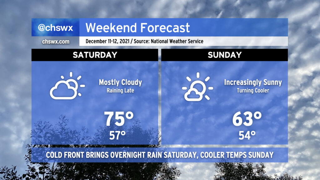
A warm front will continue to lift north across the area tonight, eroding a wedge of high pressure and setting us up for an unseasonably warm Saturday. We may start with some patches of fog during what will be a very mild morning, with lows only bottoming out around the mid to perhaps upper 50s. (The normal high for December 11 is 63°!) We’ll keep a mix of clouds and sun around as breezy southwest winds help pump in warmer air ahead of an advancing cold front. This will allow highs to top out in the mid-70s, 10°+ above normal.
Late Saturday into early Sunday morning, the aforementioned cold front will move through the area, bringing with it a weakening line of showers. It doesn’t look like we’re getting much in the way of rain out of this, so there are no real concerns as the line crosses the area. It should be out of here by daybreak Sunday (exact timing TBD), bringing a cooler airmass along with it. Highs will be right on the line for normal for December 12 on Sunday as clouds scour out, bringing us a sunny finish to the weekend.
Whatever rain we get overnight Saturday/early Sunday looks to be the only precipitation we’ll see for the next several days as our very La Niña-esque cool season rolls on. Enjoy the weekend!
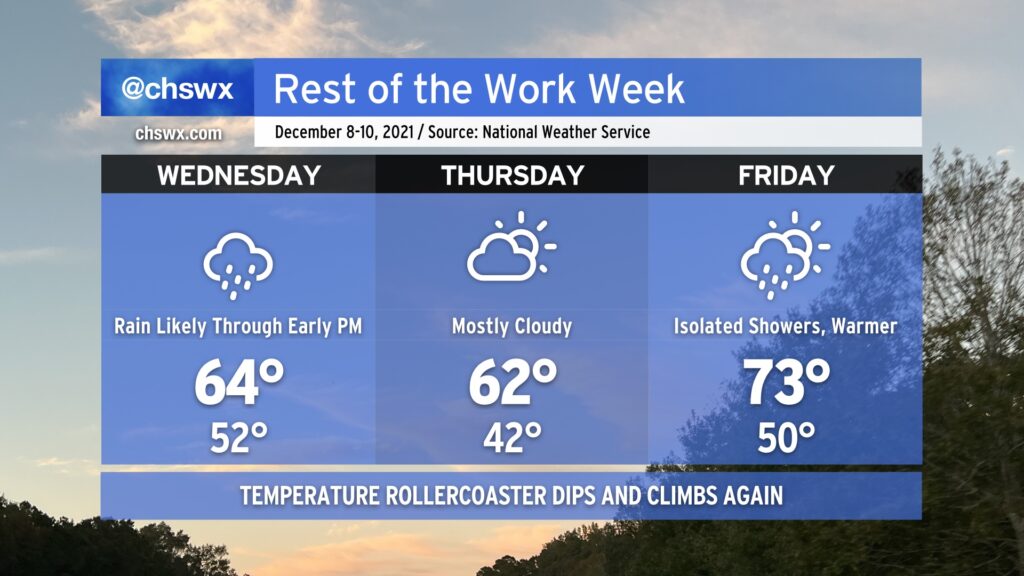
The first measurable rain in quite some time is expected heading into Wednesday through early afternoon as a cold front swings through. Don’t be surprised if you hear a little thunder, too, but no severe weather is expected. The rain will keep high temperatures pinned into the mid-60s. We could see up to an inch in some spots, which would be awfully helpful with the ongoing abnormally dry conditions and even some moderate drought in parts of the area.
We’ll dry out Thursday as high pressure builds back in, but we’ll stay cool with highs topping out in the low 60s. That cool spell won’t last long, though, as we shoot right back into the low 70s for Friday with showers a possibility in the afternoon.