Jared Smith founded @chswx on Twitter in 2008 as an experiment in disseminating weather data through social media. In the ensuing decade-and-a-half, @chswx has provided live coverage of tropical cyclones, tornadoes, severe weather, and even a couple bouts of winter weather to the good people of Charleston, SC.
A Freeze Warning is in effect overnight as a killing freeze is likely going to end the growing season across the Lowcountry. While places near bodies of water such as Lake Moultrie and coastal areas should remain above freezing, the vast majority of us look to experience at least some duration of freezing temperatures, with the longest-duration freeze well inland. Protect plants, pets, pipes, and people tonight!
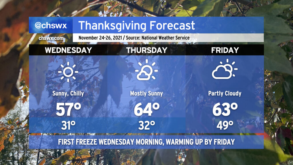
Temperatures will warm only to the mid-50s on Wednesday — perhaps a degree or two warmer than we saw today — but still well below normal for this point in November. We’ll dip back toward and likely below freezing in many spots again on Thanksgiving morning before high pressure slips offshore and return flow develops, helping temperatures to warm into the mid-60s with mostly sunny skies for much of the day. Friday morning will be considerably warmer ahead of a cold front that’ll swing through during the day. Said front will enhance cloud cover and help keep highs back into the low-to-mid 60s once again, a few clicks below normal but certainly not to the degree we experienced today and will experience again on Wednesday.
Travel safely (if you’re headed anywhere) and have a wonderful Thanksgiving holiday!
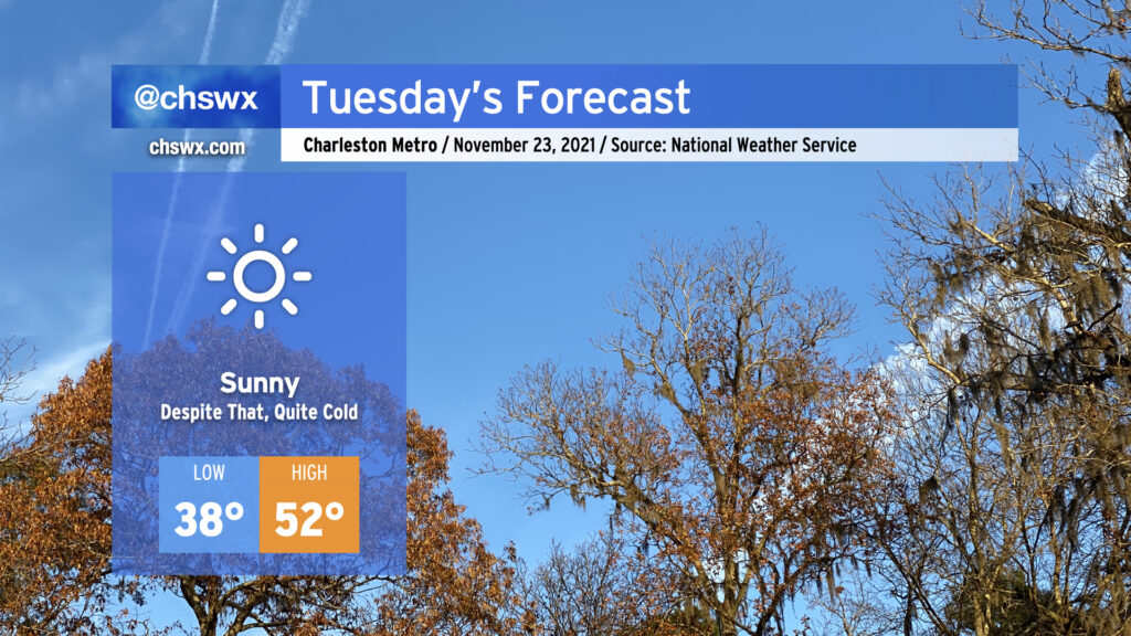
Sweater alert for Tuesday! We’ll start the day a little breezy and much cooler as a polar airmass takes residence in our neck of the woods. Air temperatures should bottom out in the mid to upper 30s away from the locally warmer coastline, but factor in the wind and it’ll feel closer to 30-32°. We’ll see predominantly sunny conditions throughout the day with just a few passing clouds at times in the afternoon; despite this, temperatures look to go no higher than the low 50s. Make sure your pets have a warm place to be tonight.
As we get into Tuesday night and Wednesday morning, winds will come down and allow radiational cooling to develop, which should be enough to get us our first freeze of the year in many spots (with widespread frost elsewhere). Lows look to bottom out from the mid-30s away from the immediate coast to possibly some upper 20s well inland. (Areas around Lake Moultrie should stay a touch warmer thanks to the influence from the warmer waters.) You’ll definitely want to make sure pets and plants have a warm place to be.
After one more frosty morning on Thanksgiving, temperatures will moderate back into the 60s in the afternoon, where we’ll stay for a couple days before a reinforcing shot of cooler air arrives in time for the weekend.
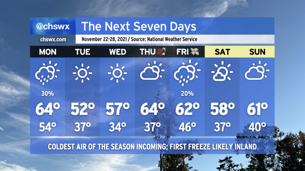
Today’s high of 73° could quite possibly be the last 70s we experience for the rest of November as a prolonged spell of below-normal temperatures is in the cards for the upcoming week. We start the abbreviated work week on a somewhat showery note as a cold front approaches the area during the day Monday. Rain chances tend to diminish as the front gets closer to the coast, but a few of you could see a few hundredths of an inch of rain during the day. The front gets through later Monday, and by Monday evening, cold air will rush into the area from the north as high pressure builds in.
We’ll start Tuesday in the mid-30s away from the locally cooler coastline, and could flirt with freezing conditions in some pockets well inland. Factor in the breezy north wind, and it’ll feel closer to the upper 20s in the morning. Highs will struggle to the low 50s in the afternoon with that persistent north wind continuing to make it feel a little cooler.
Calming winds and clear skies will provide excellent conditions for radiational cooling overnight Tuesday into Wednesday, and it appears likely that much of the area away from the coast will see its first freeze of the season with frost developing in other locations. Be ready to cover or bring in sensitive vegetation and make sure your pets have a warm place to be! Highs on Wednesday will run a little warmer than Tuesday, but still don’t look to crack 60°.
After another chilly start on Thanksgiving morning, temperatures will warm nicely into the mid-60s under partly cloudy skies. We could see a few showers on Black Friday as another cold front approaches the area with a reinforcing round of cooler air for the weekend, which looks to remain rain-free as of right now.
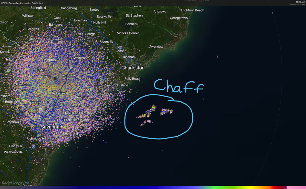
On Friday, Twitter lit up with reports of a boom that was felt in James Island and West Ashley. (I felt it too, which is unusual since I am typically oblivious to such things.)
Whenever I get reports like this, the first place I go is to USGS’s earthquakes map. Typically, when the jolt is strong enough for us to feel and it was seismic, there’s going to be something here pretty quickly. On this day, there was nothing on USGS.
The other type of jolt we feel most often around here are sonic booms, which occur as the result of trailing shockwaves from supersonic aircraft. Since the Concorde has been retired, that leaves military aircraft conducting exercises as the prime source of said booms. And sometimes, we can use weather radar to see some byproducts of these exercises, called chaff. This was the case on Friday morning with a chaff release very near the time of the sonic boom, giving increased confidence in our inference of the source of the boom.
It’s worth noting that not every sonic boom will be accompanied by a chaff release. However, when the shaking and then the chaff release happen within a reasonable amount of time from each other, it lends quite a bit of confidence in the sonic boom being the source of the shaking rather than anything seismic. This method is not foolproof, though.
A cold front will approach the area tonight, bringing with it periods of cloud cover that will occasionally obscure the view of the partial lunar eclipse (beginning around 2:30am, peaking at 4am, and ending around 5:30am). However, given that much of this cloud cover will be higher-based, it could make for some rather dramatic photography even though the moon won’t be completely clear. Something to think about as you consider your plans tonight!
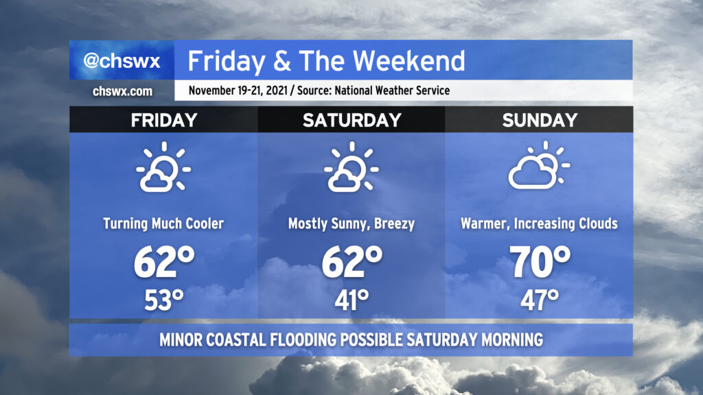
Said cold front moves through the area around daybreak Friday, and brings with it much cooler and drier air — expect highs to only top out in the low 60s despite mostly sunny skies. We’ll have more of the same on Saturday, with high pressure wedging southward a bit and kicking up northeasterly winds to yield wind chills in the low 30s in the morning before warming back to just the low 60s once more. High pressure will slip offshore quickly, though, and by Sunday we’ll feel warmer temperatures in the upper 60s to around 70° as return flow from the southwest increases ahead of another quite potent cold front that’ll swing through to kick off the abbreviated Thanksgiving work week. How potent, you ask? It may very well be enough to bring the season’s first freeze to inland locations. Highs could struggle to the low 50s next Tuesday if current forecasts pan out. Stay tuned!
There will be an outside shot at some minor coastal flooding Saturday morning given the winds shifting around to the northeast and the full moon helping to elevate astronomical tides somewhat. Right now, the forecast falls just short of the 7′ mean lower low water level that marks the coastal flooding threshold, but we’ll keep an eye on it. Thankfully, this will not be anywhere in the ballpark of the major flooding event we experienced a couple weekends ago, and the threat for coastal flooding will be relatively short-lived as winds promptly go offshore on Monday after frontal passage.
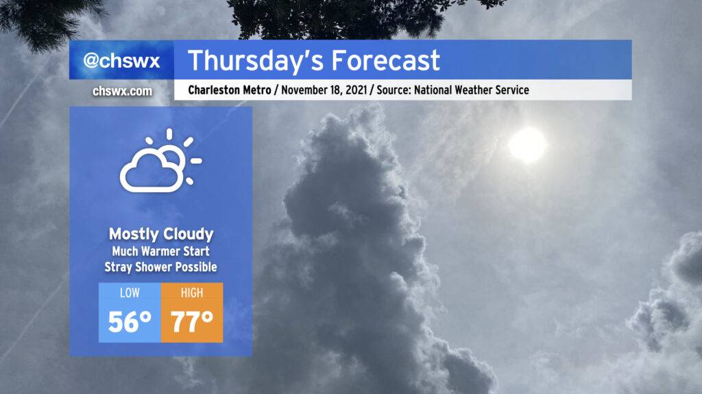
We’ve got one more mild day coming up for Thursday ahead of a cold front which will chill us out quite nicely on Friday and Saturday. Temperatures look to start about 10-13° warmer Thursday morning than they did on Wednesday, bottoming out in the mid-50s. There could be some patchy fog in the morning, so be alert on the commute for visibility drops. We’ll warm to the mid-to-upper 70s in the afternoon despite mostly cloudy skies — thank a little compressional heating and southwesterly winds ahead of the front for that. Moisture looks scant but a shower or two can’t totally be ruled out for a few of you; the NWS forecast has 10% probability of precipitation so if there is any measurable rain, it’s likely going to be very limited in scope.
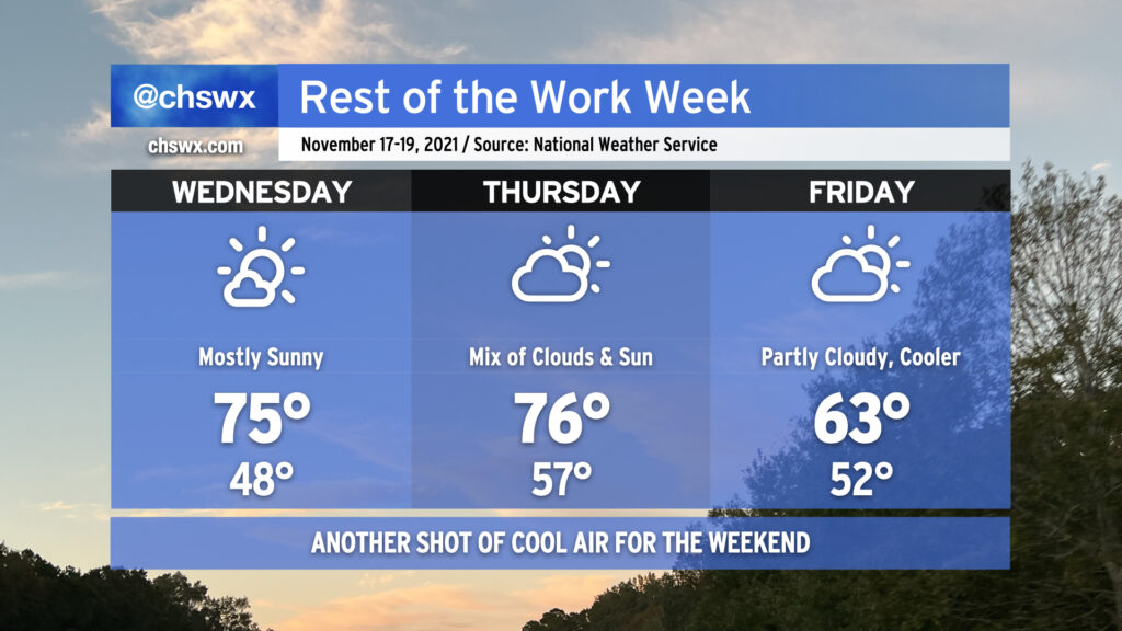
After the front gets through, we have a couple days in the low-to-mid 60s coming up for Friday and Saturday before warming back to the low 70s on Sunday. Keep sweaters on standby for the first part of the weekend!
After topping out at 72° today away from the cooler coastline, we’re back into the 70s for a couple more days before a cold front swings through for Friday, allowing high pressure to wedge into the area for the weekend. We’ll actually see a few clouds on Wednesday before an increase in cloud cover Thursday in response to the cold front approaching the area. There’s a tiny chance that we may see a shower or two, but the relative dearth of moisture should keep the vast majority of us rain-free. Cool high pressure builds back into the area on Friday, keeping high temperatures well into sweater weather territory in the low 60s in the afternoon. Overall, not a bad way to close out the last work week before Thanksgiving.
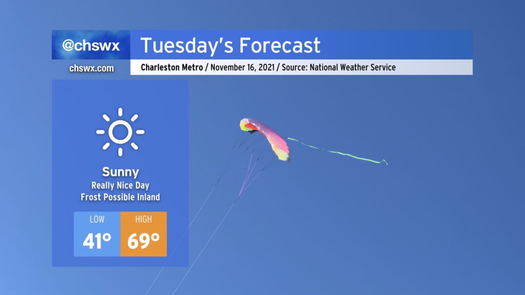
Tuesday is looking really, really nice with high pressure firmly in control of our weather. A dry atmosphere and plenty of sinking air will keep skies clear, and the airmass will modify just a touch to yield highs in the upper 60s to around 70° in the afternoon.
We may deal with some frost formation in the morning. A Frost Advisory is in effect for inland Berkeley and Dorchester counties. Cover up or bring in sensitive plants tonight into Tuesday morning. Other than that, though, no major weather concerns at all.
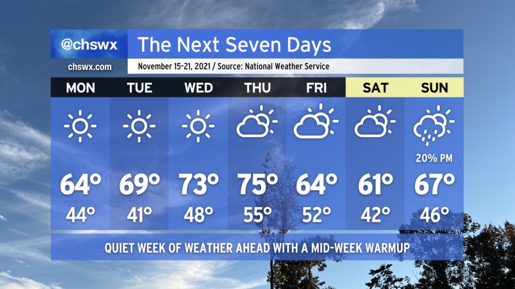
We’ve got a quiet weather week ahead thanks to high pressure and dry air, especially in the first part of the week. Monday gets us off to a cool start, with lows in the mid-40s in the metro only warming to around 64-65° in the afternoon despite full, uninterrupted sunshine. We keep mostly sunny skies in play through Wednesday as high pressure slips offshore, allowing temperatures to warm up into the low 70s by mid-week. A reinforcing shot of cool air arrives Friday with a dry cold front, knocking temperatures back into the 60s for the weekend. A shower or two could pop on Sunday as high pressure wedges southwestward across the area and a coastal trough develops, but it’s certainly not enough to cancel any plans. Enjoy it — it’s hard to believe that we’re just a little over a week out from Thanksgiving at this point!
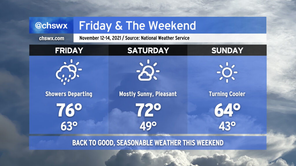
We’re back to nice weather this weekend as a series of dry cold fronts move through, reinforcing progressively cooler and drier air as time goes on. Any leftover showers should be departing with the front Friday morning, and despite frontal passage, we should still warm into the mid-70s but with lower dewpoints spreading into the area. Winds out of the west and northwest could have a little downslope component to them, which will aid in warming us a few degrees above normal for the afternoon.
Saturday looks excellent, with mostly sunny skies and temperatures around or just a hair above normal ahead of another front that looks to get through the area later in the evening. This front brings in another shot of cooler and drier air for Sunday, which certainly could prompt a sweater weather watch with highs in the mid-60s despite full sunshine. Overall, I would say this weekend’s weather will dramatically outclass the mess that was last weekend.
While we reached minor flood stage once again in the harbor early this afternoon — eight consecutive days of coastal flooding, for those of you counting at home — the risk for additional coastal flooding is extremely low going into Friday and virtually nonexistent heading into the weekend. (And thank goodness for that.)