Jared Smith founded @chswx on Twitter in 2008 as an experiment in disseminating weather data through social media. In the ensuing decade-and-a-half, @chswx has provided live coverage of tropical cyclones, tornadoes, severe weather, and even a couple bouts of winter weather to the good people of Charleston, SC.
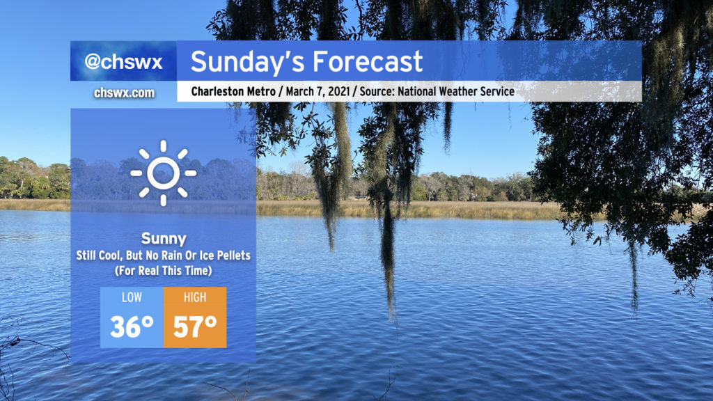
It was a weird Saturday. (More on that in a minute.) Fortunately, Sunday will restore order to the forecast as clouds dissipate overnight in response to high pressure building back into the area. Despite full, unencumbered sunshine, we’ll stay quite chilly tomorrow, with the high of 57° coming in well under the normal of 68° for this point in March. Frost and even a light freeze will be possible overnight Sunday into Monday, too, so be ready to protect plants and pets.
But yes, no surprise rain or ice pellets. For real this time. And thankfully (for our psyches, anyway), we look predominantly dry well into next week and perhaps beyond.
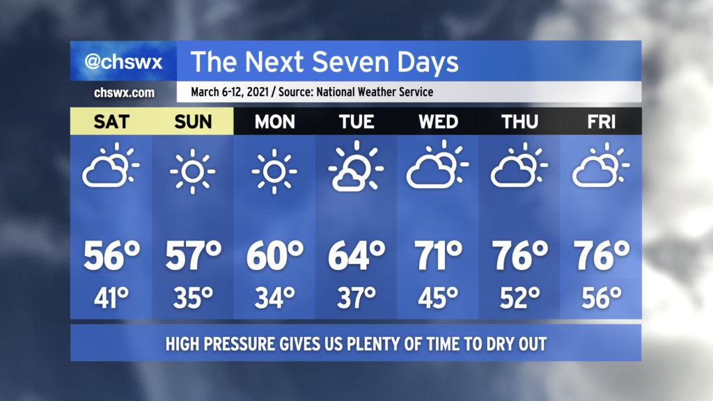
I don’t remember the last time the seven-day forecast was so calm. High pressure remains in control, which means little to no rain chances and steadily warming temperatures into the 70s by the end of next week. It’s a worthy reprieve from what’s been a soggy start to 2021 so far.
Saturday will be a bit on the cloudy and cool side, with highs topping out in the mid-50s with peeks of sun becoming more frequent in the afternoon. Sunday is my pick day of the weekend; despite temperatures remaining well below normal, there will be plenty of sunshine, and the March sun angle will hit a little differently than, say, January.
From there, a warming trend will commence, and by the end of next week, temperatures look to be running a few degrees above normal in the mid-70s.
The only weather concern of note will be the potential for frost and freeze conditions each morning starting Sunday through Tuesday. If you’ve planted, be ready to protect that sensitive vegetation and make sure your pets have a warm spot to be.
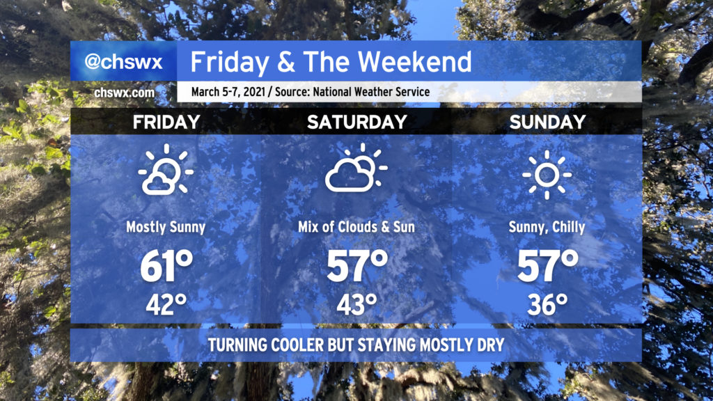
After a very turbulent stretch lasting over a month, it looks like we finally will be getting an extended period of mostly quiet weather. That began with today’s Severely Nice Weather Alert Day, which featured cobalt blue skies and highs topping out around 70-71° across the area.
Overnight, a cold front will backdoor in from the north, switching winds northeasterly and keeping temperatures cooler for Friday. Expect mostly sunny skies throughout the day with clouds increasing late as some upper-level energy ripples through the area. A shower or two can’t be totally ruled out overnight Friday into Saturday, but the chances are super-low right now.
We’ll start Saturday with a fair bit of cloud cover, but do expect the sun to be peeking through with increasing frequency as the day goes on. Temperatures will remain rather chilly by early March standards, only topping out in the upper 50s.
Cloud cover will dissipate for Sunday as high pressure continues its reign over our weather. Despite full sunshine, temperatures will once again only rise to the upper 50s, well below normal (68°).
As we get into next week, there will be some frost and freeze potential, so be aware if you’ve started planting. Otherwise, though, it looks like an extended period of mostly quiet weather is in the offing — good news for this rain-weary populace.
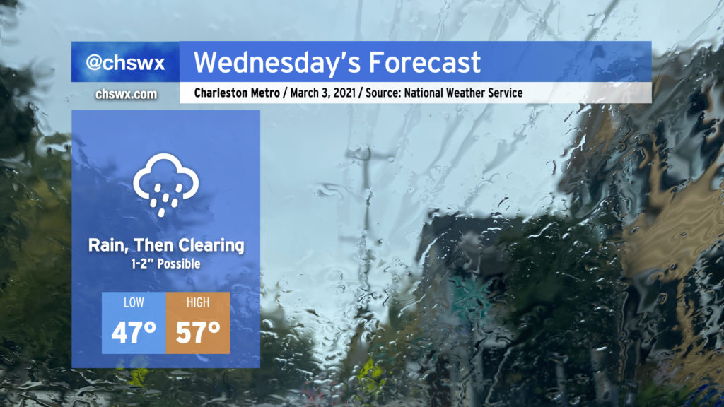
Expect a soaking rain to pick up overnight and last through early Wednesday afternoon. Rain totals should end up being around 1-2″ across much of the Tri-County with locally heavier amounts. If there’s a piece of good news in this, right now it appears that the heavier rain is going to miss our next two times of high tide (10:33 PM Tuesday, 10:49 AM Wednesday). Salt water flooding remains a concern around times of high tide, though, with a Coastal Flood Advisory until midnight as the 10:33 PM high tide will approach 7′ in the harbor. If rain does pick up around that time, there could be more trouble on area roads, so be aware of that possibility through tomorrow.
Low pressure will depart the area Wednesday afternoon, which will shut the rain off and allow skies to begin to clear out. Depending on the timing of the clearing, we should see temperatures rise to the mid-to-upper 50s in the afternoon, setting up a rather nice Thursday with clear skies and highs in the mid-60s.
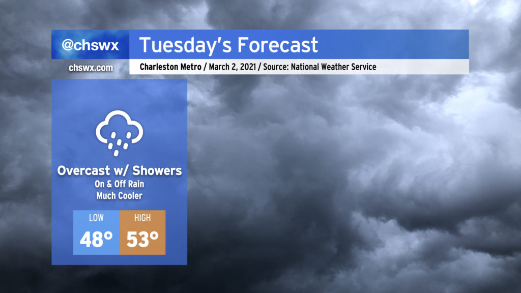
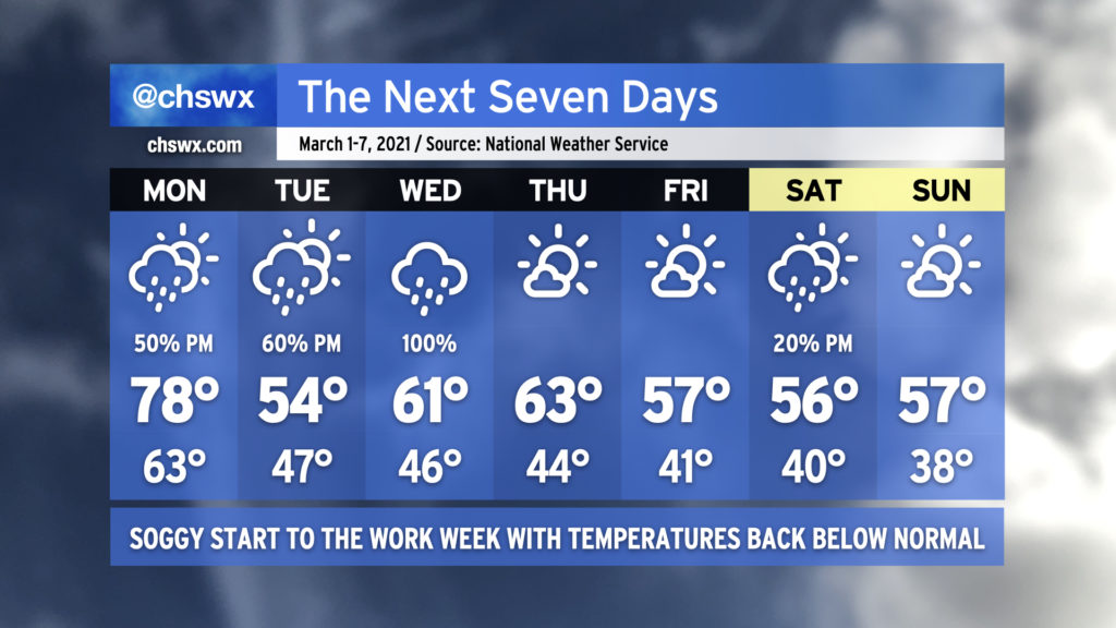
Stop me if you’ve heard this one before: We’re looking at a mostly cloudy day with occasional showers for Tuesday. Alas, March throws it back to mid-February tomorrow as temperatures only top out in the low 50s in the afternoon as cold air damming develops in the wake of this evening’s frontal passage. It won’t rain all day, but you’ll want to keep the gear close by in case you find yourselves in some showers. We’ll stay in the muck through Wednesday, with clearing developing on Thursday, but temperatures will remain well below normal for the rest of the week.
We begin meteorological spring with one more day in the 70s and increasing rain chances ahead of a cold front. The front will push southward across the area late Monday, leaving us significantly cooler for Tuesday and beyond. (I hope you’ve not put your sweaters away yet!)
The cold front will stall somewhere near the Gulf Coast, and low pressure will spin up and traverse it. Rain chances will come up ahead of this low pressure system later Tuesday, with widespread showers expected on Wednesday. Once low pressure departs, we should get a couple dry days in before a coastal trough possibly generates a few showers in the area on Saturday afternoon. High pressure is projected to usher this trough away from the area for Sunday.
I suspect the temperature shift back to below normal is going to be a bit of a jolt, especially after closing February with a weekend featuring highs in the 80s each day. Normal highs for the first week of March are around 66-67°, and it just doesn’t look like we’re going to get there this week.
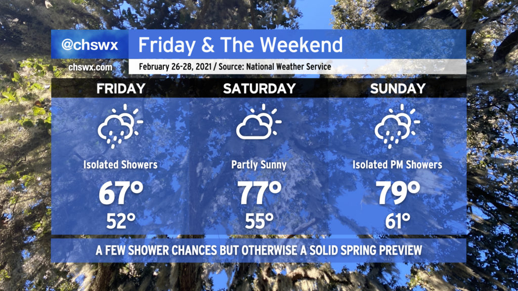
We’ll cool off some on Friday as a backdoor cold front stalls out across the area. We could see quite a spread in temperatures across a short distance; while the forecast for the Charleston metro area is in the mid-to-upper 60s, it could be much cooler north of the front in northern Berkeley County. There will be a chance of a shower or two in the afternoon, but nothing too out-of-band (and definitely nowhere near the recent rains).
By Saturday, that stalled front lifts north across the area as a warm front, and we return to the mid-to-upper 70s across the area. Saturday’s the pick day with dry weather expected and scattered clouds. Sunday may feature a few showers with temperatures approaching 80° in the afternoon.
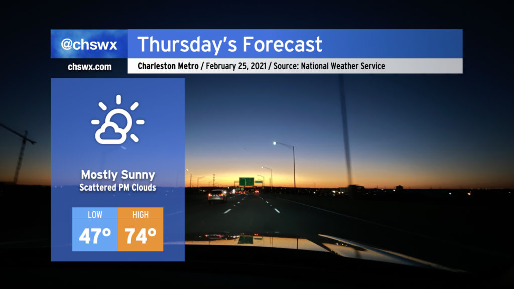
We’ll continue our nice weather winning streak into Thursday as temperatures will once again get into the mid-70s under mostly sunny skies. We’ll begin to see some clouds re-enter our skies tomorrow with a little more moisture moving in as a backdoor cold front moves across the Mid-Atlantic during the day, but no rain is expected. Overall, expect another pleasant day across the area.
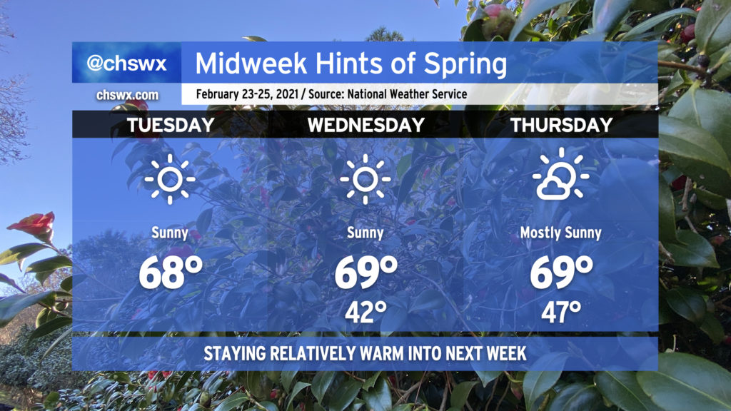
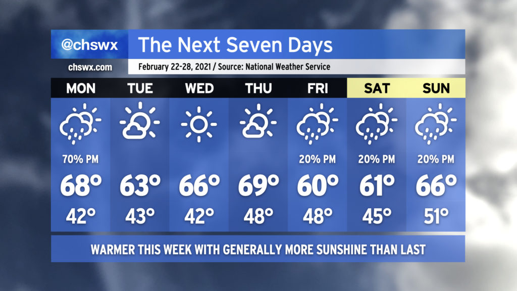
We’re about to embark on what arguably will be the nicest stretch of weather so far this month. Temperatures will top out near 70° each day, with mostly sunny skies prevailing as high pressure remains in control for a few days. And while slight rain chances return to the picture Friday, the cold does not: expect above-average temperatures to continue as we roll into the beginning of March. I feel like we’ve earned this. Enjoy!
Rain chances will make a brief return to start the week, but without the ridiculous tap of moisture that characterized the last few rainstorms. The recent deluge has led to river flooding in spots on the Edisto as well as on the Santee at Jamestown, with homes being threatened in Ridgeville. Overall, though, expect a quieter week of weather with warmer temperatures than we’ve been used to.
As mentioned before, Monday starts ahead of a cold front with scattered showers coming onshore for a fair bit of the day. However, the best chance of showers will be in the afternoon and evening hours as the front passes. Temperatures will rise into the upper 60s and could even crack 70° in a few spots.
Tuesday through Thursday look really nice, with ample sunshine and progressively warmer temperatures, again potentially touching 70° on Thursday.
Our next rain chance arrives Friday afternoon in the wake of another front. Isolated showers will be possible each afternoon through the weekend, but right now we should not see any washouts. Temperatures will remain near or slightly above normal.
This is the last week of meteorological winter; meteorological spring begins on March 1st. (Meteorologists and climatologists use March 1 to mark the start of spring as it is a consistent point for record-keeping. The vernal equinox, which ushers in the more traditionally accepted definition of spring, is on March 20.)