2021 to get off to a stormy start
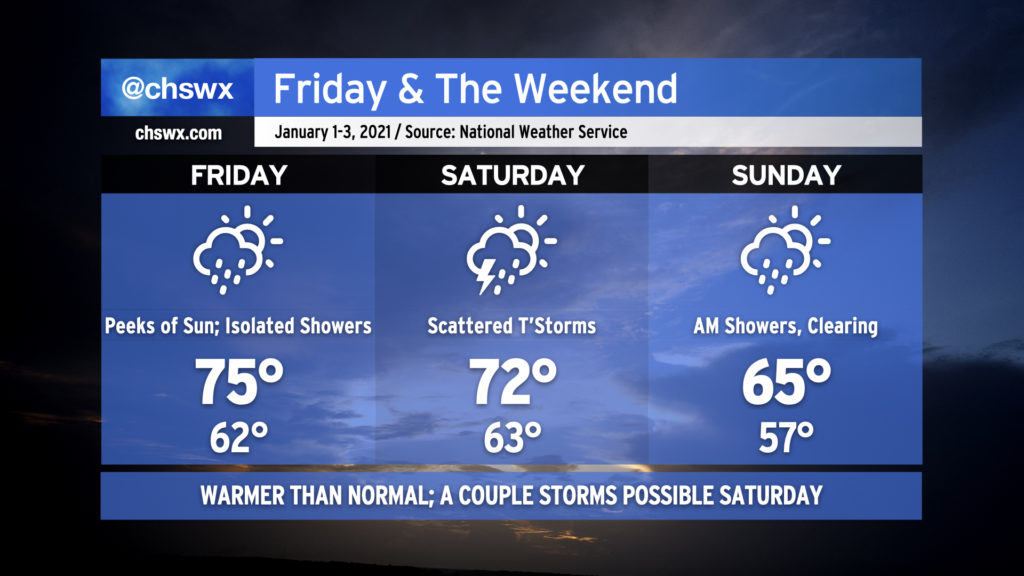
We’re going to get 2021 off to a bit of a stormy start as a cold front affects our weather Friday and into much of the weekend before clearing the area Sunday afternoon.
Read more »We’re going to get 2021 off to a bit of a stormy start as a cold front affects our weather Friday and into much of the weekend before clearing the area Sunday afternoon.
Read more »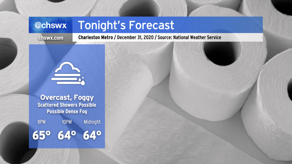
It’ll be a warm but overcast night across the area as we flush 2020 and try again in 2021. Temperatures will hold in the mid-60s as the clock turns midnight, owing to the muggy airmass in place. Said muggy airmass will allow fog to develop later this evening as well; some patches of it may become dense, and NWS notes in its discussion that a Dense Fog Advisory could be required.
Watch out for a few scattered showers coming in from off the ocean this evening as well, but the bulk of the activity looks to remain northwest of here as rain continues to fall into the remnants of the cold air damming regime. Depending on where the front ultimately ends up, we could see that enhanced rain risk come a little closer to 17-A, but we’ll keep an eye on it.
Overall, it’s not the worst weather to end 2020 with, especially considering how this year has gone. I wish you all a very Happy New Year!
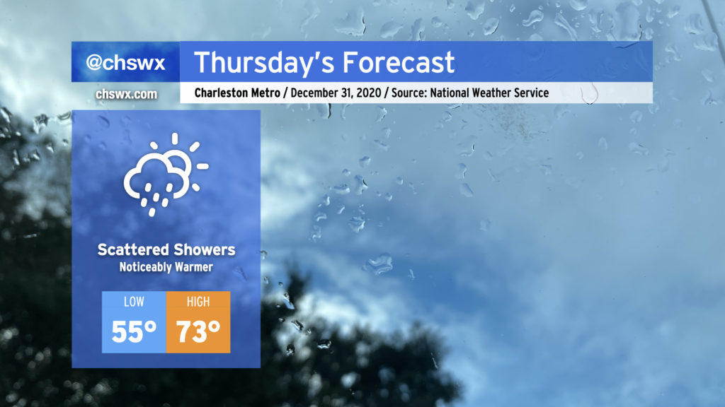
We’ll say goodbye to 2020 with quite a few choice words, warm temperatures, and perhaps a few showers mixed in at times. Showers will be possible at any point during the day Thursday, including up to midnight, so keep rain gear close if you are out and about.
Temperatures will turn noticeably warmer, with highs recovering into the 70s as we enter the warm sector ahead of our next storm system, which will hang around for a few days before clearing the area Sunday.
Read more »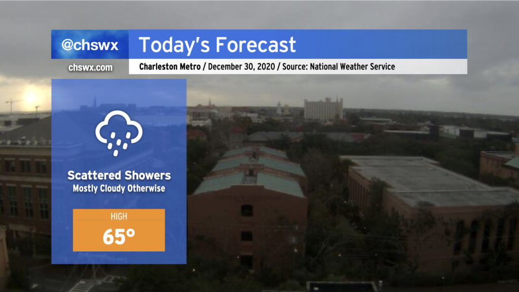
High pressure wedged in from the northeast combined with moisture overrunning a nearby coastal trough will keep clouds and scattered showers in the forecast today. This trough will eventually lift inland later today into tonight, swinging winds back around to the southeast and perhaps warming things up a touch. Generally speaking, plan for highs in the low to mid-60s across the area, and keep rain gear nearby. Rainfall amounts should generally remain light.
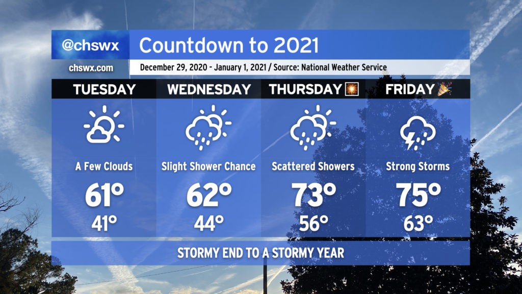
2020 looks to hand off to 2021 in the fashion we would expect from this year — a bit on the warm and stormy side — as a cold front approaches the area from the west.
The last few days of the year will get progressively warmer, with 70s back in the picture for New Year’s Eve. Rain chances also return beginning Wednesday, with a shower or two possible as a coastal trough moves inland in response to high pressure to the northeast breaking down and moving out. Rain chances improve for Thursday along with a noticeable jump in temperatures (70s!) as warm and moist air overspreads the area ahead of our next storm system.
Overall, if you’ve got things to do outdoors, Tuesday’s your best day to for-sure avoid rainfall. As for New Year’s Eve, I’m not expecting a washout for fireworks displays as of now, but the devil is in the details. Stay tuned.
Read more »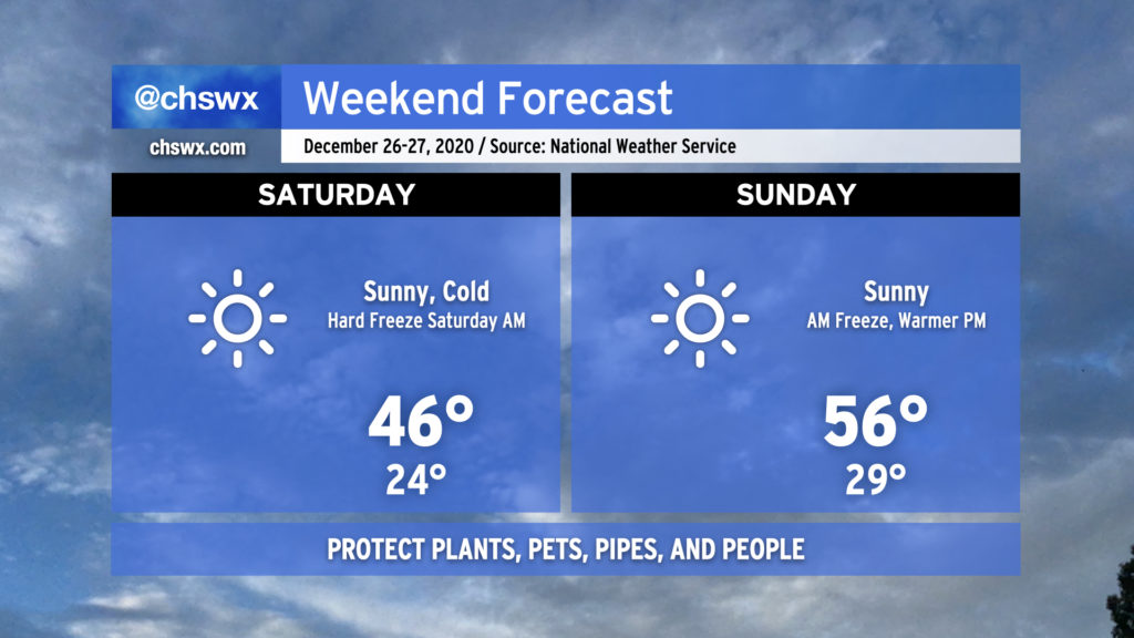
Get ready for a hard freeze tonight as temperatures plummet into the low-to-mid-20s pretty much everywhere inland of the immediate coast, where temperatures will still likely reach freezing. While winds will die down a little, there will still be enough to send wind chills into the upper teens for Saturday morning. Protect plants, pets, pipes, and people tonight.
Saturday will be another day where temperatures struggle into the mid-40s despite full sunshine. After another freeze Sunday morning, temperatures will begin to moderate, topping out in the mid-50s in the afternoon with plenty of sunshine to continue.
Read more »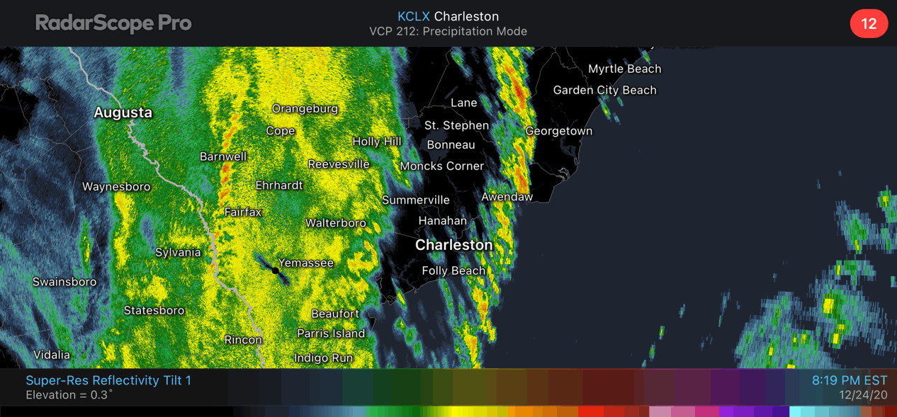
The primary squall line has moved out of the area, with more rain moving back in behind it as the cold front approaches. Said front is moving through the Midlands now and is approaching I-95.
Strong wind gusts can be expected as the front passes through, then the bottom falls out of the thermometer as cold air rushes into the area. We will start the day very near, if not below, freezing away from the coast. Things should dry out fast enough where ice won’t be a concern in much of the Tri-County, but it can’t be totally ruled out near I-95.
Tomorrow will warm only into the low 40s with strong cold advection continuing throughout the day.
A broken squall line is moving into the Tri-County now. This squall line will be capable of 50 MPH wind gusts with some pockets of stronger, damaging winds. Kinks along the edge of the line may produce brief tornadoes; a tornado warning was in effect earlier in Hampton and Colleton counties with some indication of debris as the tornado moved over Luray.
There is enough instability available for additional episodes of severe weather over the next hour or so. Once the initial squall line passes — and it’ll be fast as it’s moving to the east/northeast at 45-50 MPH — rain will fill into the area with continued gusty winds. Be ready for the potential for power outages — charge devices now and have flashlights on standby.
The cold front is moving into South Carolina now. As the front moves through, expect a sharp wind shift and an additional round of strong, gusty winds as precipitation ends. Cold air will quickly follow.
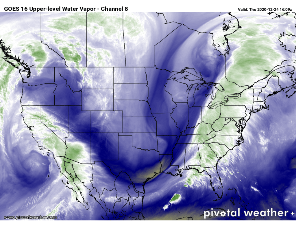
We in #chswx continue to monitor the risk for strong to severe thunderstorms this afternoon and evening as a strong cold front driven by a highly amplified upper-air pattern makes its way to the coast.
Read more »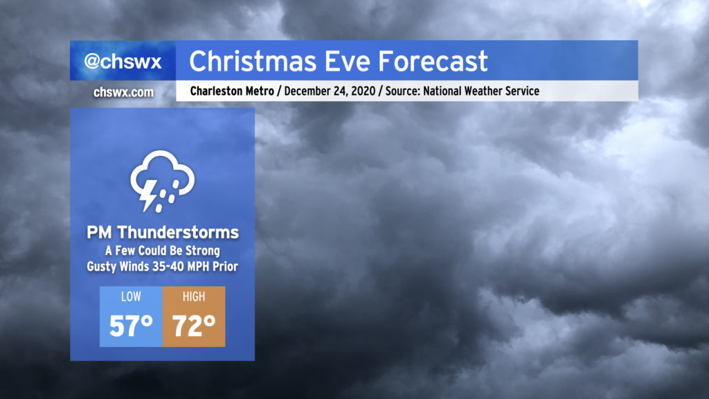
Details are coming into focus around what will be quite a strong storm for the Eastern Seaboard for Christmas Eve. Model guidance is in unanimous agreement for a strong band of showers and thunderstorms ahead of the cold front that could produce occasional damaging wind gusts during the afternoon and early evening hours. The good news is that this activity should get out of here by the time Santa is ready to make his rounds in the Lowcountry.
Read more »