Jared Smith founded @chswx on Twitter in 2008 as an experiment in disseminating weather data through social media. In the ensuing decade-and-a-half, @chswx has provided live coverage of tropical cyclones, tornadoes, severe weather, and even a couple bouts of winter weather to the good people of Charleston, SC.
Monday and Tuesday sure won’t feel like June in the wake of a cold front that came through earlier today. Cool high pressure will wedge into the area, and the resulting onshore flow will keep temperatures rather pleasant and cloud cover reasonably low to start the new work week. We’ll begin a warming trend on Wednesday with a return to the 90s by Thursday. Next rain chances arrive by this weekend.
Tropical Storm Bertha at landfall northeast of Charleston on Wednesday morning.
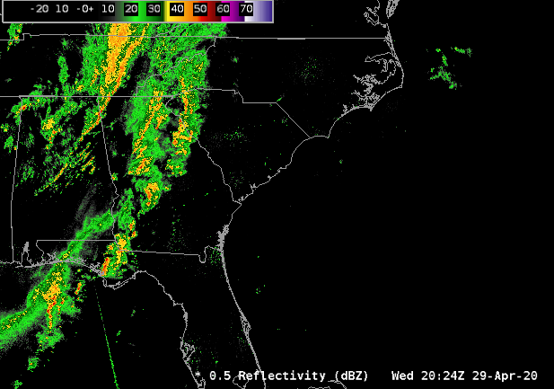
In case you missed it — and you’ll be forgiven if you did — we had our first landfalling tropical cyclone of the 2020 hurricane season on Wednesday. Tropical Storm Bertha, which was classified as such when it was 30 miles southeast of Charleston, came ashore around 9:30am with maximum sustained winds (primarily offshore) of 50 MPH. Bertha was not a major wind-maker on land, but dropped enough rain at low tide to cause flooding in downtown Charleston. Its heavy rain spread inland, adding to rain totals on what has been a soggy second half of the month already. Charleston Airport set a new rainfall record on Wednesday, as well; 2.08″ broke the record of 2″ set in 1977.
We’re getting a rainy start to our Tuesday as showers spread northward ahead of a low pressure system that is hugging the Florida coast. While some of these showers could be heavy at times, flooding is not expected to become an issue during the day on Tuesday. The worst weather is poised to arrive later tonight and into Wednesday as the center of the low makes its closest approach. Let’s get a look at what that means…
UPDATED at 6:30 PM: The National Weather Service in Charleston has confirmed a tornado on Johns Island yesterday. The tornado went a little over 3/4 of a mile along Chisholm Road, downing trees and power lines before dissipating over Church Creek. The storm survey team also found straight-line wind damage along Maybank Highway between Angel Oak Road and Oak Grove Road.
Some much-needed rain is in the forecast for much of the upcoming week as a cold front with an accompanying upper low moves through the area. Said upper low will then stall out over the Southeast into the end of the week, keeping thunderstorm chances around and temperatures a little below normal. As the upper low shifts away from the area toward Friday and the weekend, we’ll see rain chances decrease and temperatures approach the 90° mark. Overall, expect around an inch of rain before the week is over, with locally heavier amounts possible in thunderstorms — a healthy amount of rain, but not all at once, thankfully.
High pressure will be in firm control of our weather this week, keeping rain-free conditions and partly to mostly sunny skies in play. We’ll start the week with temperatures continuing to run below normal as one more front gets through the area early Monday. From Wednesday on, a warming trend will begin as high pressure sets up offshore, bringing warmer air in from the south and allowing temperatures to head up to the mid-80s by the weekend. A few scattered PM showers and storms will be possible Saturday and Sunday, but no washout is in store. Enjoy it (six feet away from others)!
850mb temperatures and 500mb heights from a RAP13 model projection in May, I swear.
A relatively mild winter has one last trick up its sleeve as an unusually chilly airmass has descended from the Arctic onto the eastern half of the country. This brought Central Park in New York City only its second May 9 snow on record (first was in 1977) and has helped send numerous low temperatures to record levels all the way into Alabama and Mississippi.
We’ll go from abnormally warm to abnormally cool in the course of these next seven days as a very late-season shot of Canadian air comes down the eastern half of the country in time for Mother’s Day. First, though, we continue with our more summer-like conditions to start the week. A cold front will sag south during the day on Monday, helping to drive temperatures back into the upper 80s out ahead of it with the potential for some showers and storms along it. The front will meander in the area for a couple days, and as upper-level disturbances traverse it, it is possible that we may see some showers and thunderstorms.
Another front swings through Wednesday, cooling us off back into the upper 70s, followed by a reinforcing shot of cooler, drier air for the weekend as an unusually cold airmass of Canadian (and perhaps Arctic) origin surges southward into the eastern half of the Lower 48, sending temperatures well below mid-May normals in the low 80s. While we won’t see any frost or freeze concerns, you won’t have to go too terribly far north to find some! In fact, it is conceivable that the current NWS highs might be generous if some of the ensemble members are to be believed. Regardless, though, Mother’s Day should look pretty good across the Lowcountry!
Showers and thunderstorms associated with a cold front will move through the area tonight, bringing with it some brief heavy rain and perhaps the risk for a damaging wind gust or two through early Thursday morning. This is not the high-end risk we have seen in a few times in the past few weeks — not by a long shot! — but you may want to have a flashlight at bedside just in case of a brief power outage overnight as some sporadic wind damage does appear possible.
We’ll broach 80° tomorrow despite increasing cloud cover as a cold front approaches the area from the west with our main rain chance this week. There is a small chance that showers could develop near the coast in the late afternoon hours, but the best rain chances arrive overnight into Thursday morning with a band of showers and thunderstorms. Fortunately, severe weather is looking rather unlikely, though a few strong wind gusts will be possible. Will have more on this rain threat tomorrow as timings become more apparent — stay tuned.