Jared Smith founded @chswx on Twitter in 2008 as an experiment in disseminating weather data through social media. In the ensuing decade-and-a-half, @chswx has provided live coverage of tropical cyclones, tornadoes, severe weather, and even a couple bouts of winter weather to the good people of Charleston, SC.
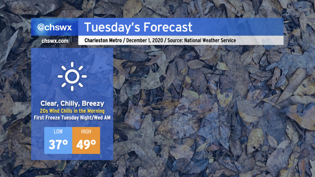
We in the weather community have been talking about this cold snap for a while, and it is finally here. Tuesday promises to be a very chilly day — the coolest since mid-February — with highs struggling to reach 50° despite full sunshine. A persistent westerly wind will keep temperatures feeling even colder, too, with wind chills in the upper 20s expected in the morning. Make sure your loved ones, two and four-legged, have a warm place to be tonight (and for the next couple nights).
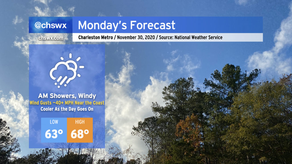
We’ll get this week off to a rainy and windy start as the storm system which rained on us for a fair bit of today moves through the area on Monday, ushering in the coldest air of the season in its wake.
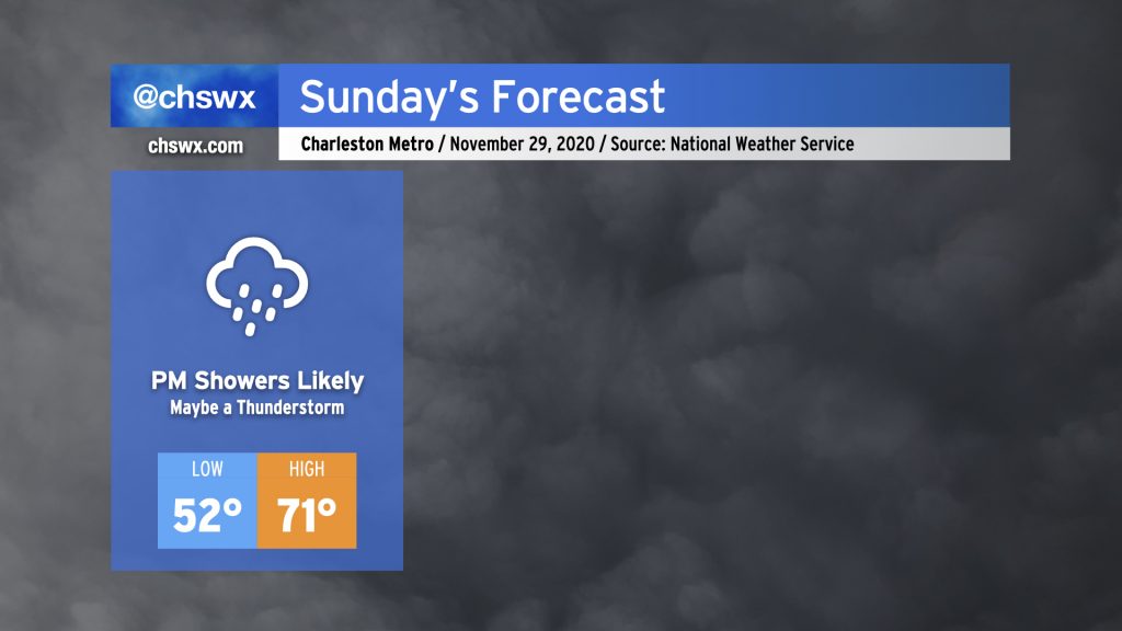
Sunday will start out dry and mostly cloudy, but will turn more rainy as a warm front lifts north across the area during the afternoon and evening. This rainfall is associated with a storm system that will move across the Gulf Coast states tomorrow and then more northeastward into the Mid-Atlantic Sunday night into Monday, ushering in a legit winter chill behind it — just in time to start meteorological winter on Tuesday.
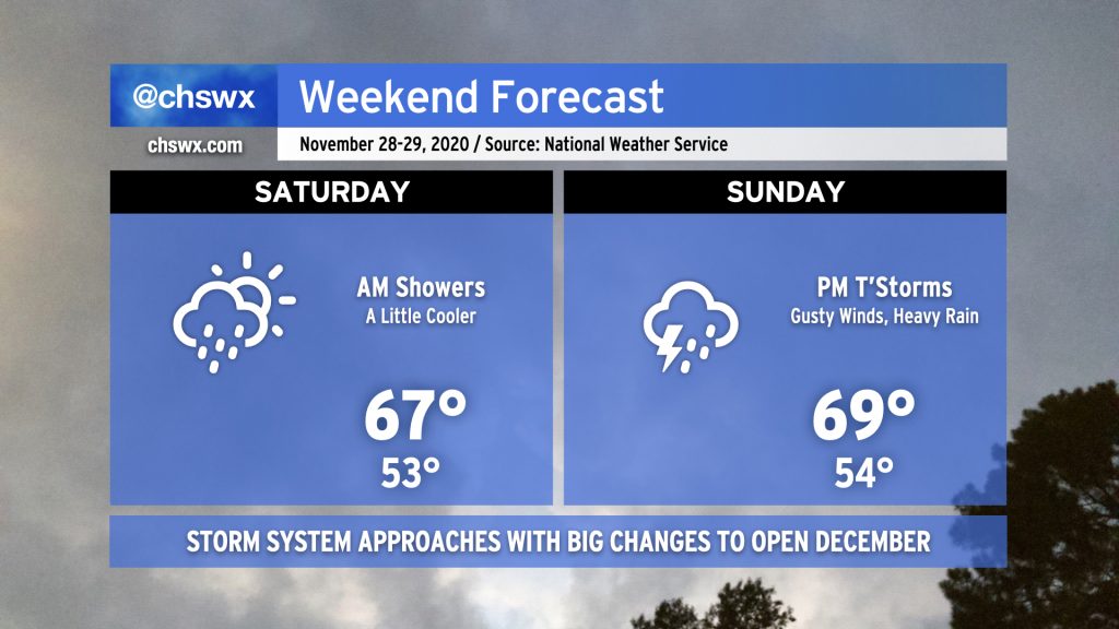
While it’d be unfair to characterize the weekend as a washout, we do face periods of unsettled weather as a frontal boundary remains stalled to our south in Georgia and a potent storm system approaches the area from the west.
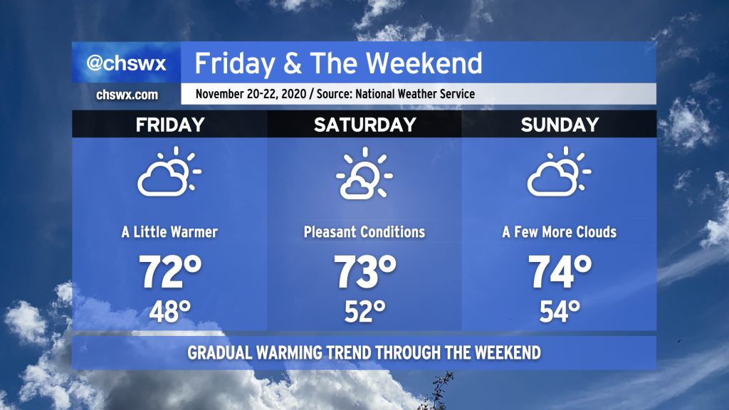
Saturday morning, expect light rain to move across the area as a wave of low pressure along the stalled front moves from west to east with a little upper-level support to boot. It’s not likely that we’ll see much more than a tenth or two of an inch of rain across the Lowcountry from this round of rain, and it should conclude by early afternoon. We should get at least a few peeks of sun before Saturday’s all said and done, and the evening will remain dry. Temperatures will run a little cooler than previous days, only topping out in the upper 60s.
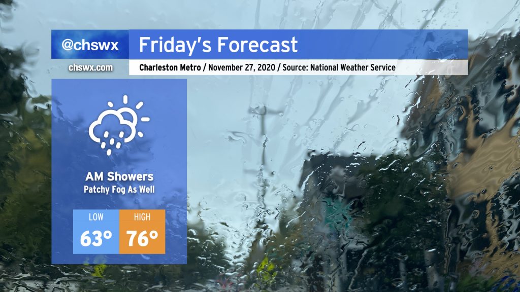
We’ll start the Friday after Thanksgiving with some showers as a cold front slowly trudges through the area. Once this front is through, rain chances will decrease and we should have a fairly nice afternoon, with temperatures still running well above normal in the mid-70s — though not quite getting to 82° like we did today.
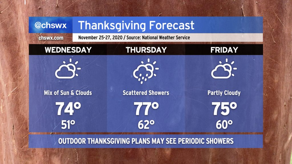
After a pretty quiet weather day with temperatures only topping out in the mid-60s, we will see a warming trend commence beginning Wednesday. Cloud cover will also increase as a storm system approaches the area for Thanksgiving. There will be a risk for isolated to scattered showers for Thanksgiving Day, but the warmth will be a little more noticeable with highs topping out in the upper 70s. A weak front will then clear the area, knocking temperatures down a little for Friday and bringing back a mix of sun and clouds. Overall, not too bad, but you will want to be ready to cover up any outdoor Thanksgiving activities just in case.
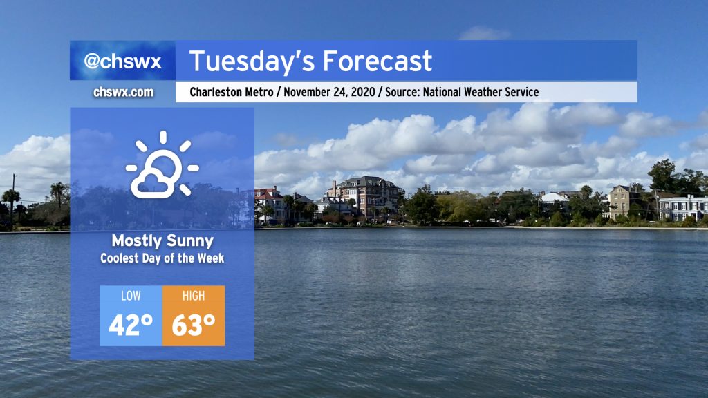
Cool high pressure will be in control of Tuesday’s weather, with highs topping out in the low to mid-60s across the area under mostly sunny skies. A breeze out of the east will keep it feeling a little more brisk during the day as well. Overall, not too shabby with temperatures running a touch below normal.
Clouds will be on the increase Tuesday evening into Wednesday as our next storm system approaches the area, first bringing a warmup and then possibly some Thanksgiving rain.
Aside from Monday evening into Tuesday, Thanksgiving week will shape up a bit on the warm side, with a few showers for Thanksgiving Day possible.
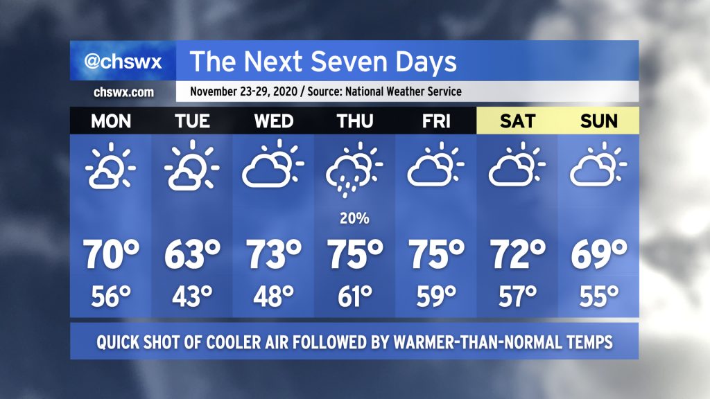
Overall, the pattern will be pretty progressive this week. We’ll start the week with a cold front swinging through during the day Monday. This will knock temperatures back into the low 40s by Tuesday morning, with highs only reaching the mid-60s during the day. High pressure quickly shifts eastward, though, allowing for temperatures to moderate (and clouds to increase) ahead of another front Wednesday. The next front looks to swing through Thursday into Friday, and this is where we may see a few showers develop. (Right now, chances are low.) Temperatures will then level off a little lower, with perhaps some rain chances toward the end of the weekend depending on the forward speed of another storm system.
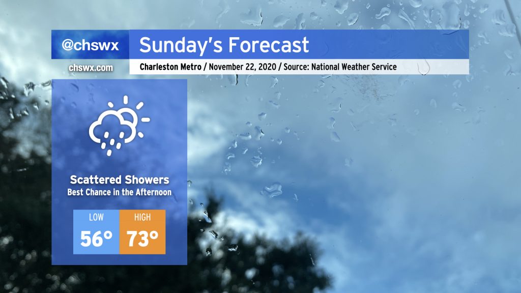
As high pressure to the northeast weakens and moves away, a trough of low pressure along the coast will move inland, and along with it will come a chance of showers for Sunday. The best risk for showers will occur in the afternoon. Not everyone will see rain and it won’t rain all day — just keep an eye to the sky and be ready to deploy the rain gear if you need to. Temperatures will remain mild (but not horribly so) for this time of year with highs topping out in the low 70s.
After a couple chilly days, the 70s return to the weather picture starting Friday and through the weekend. The warming trend will be very gradual, but expect Friday to start in the upper 40s, with low 50s for Saturday and perhaps mid-50s for Sunday. We’ll see a little more cloud cover than we have in previous days, but overall the weather should remain quite pleasant for the weekend before Thanksgiving.