Jared Smith founded @chswx on Twitter in 2008 as an experiment in disseminating weather data through social media. In the ensuing decade-and-a-half, @chswx has provided live coverage of tropical cyclones, tornadoes, severe weather, and even a couple bouts of winter weather to the good people of Charleston, SC.
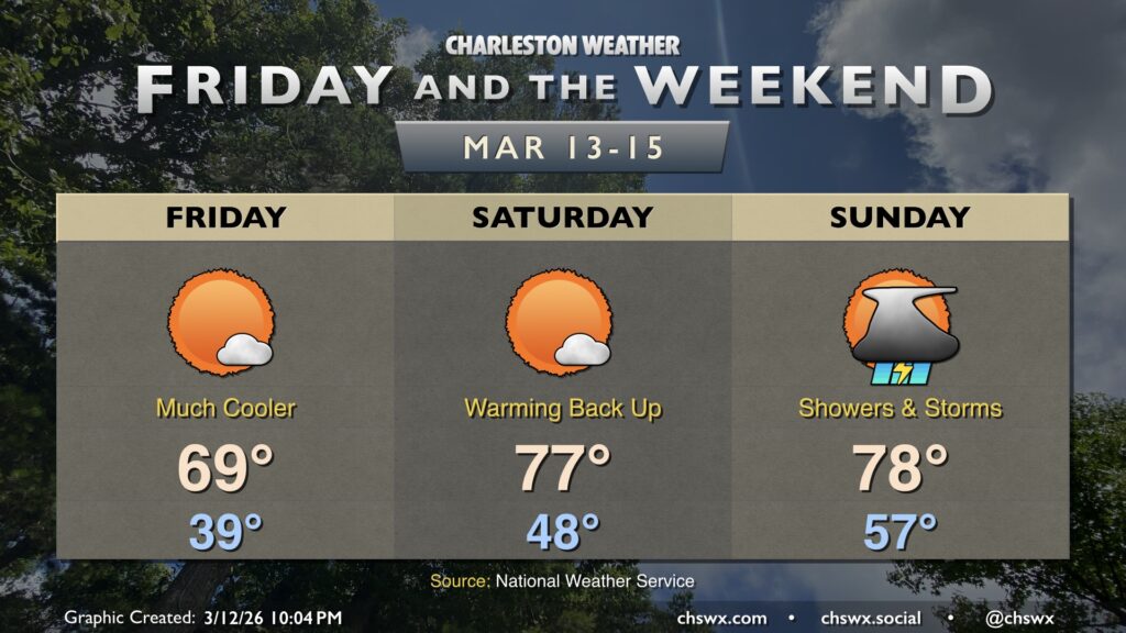
Friday will feel a lot different than much of the past week has, courtesy of a cold front that came through and put a chill back in the air Thursday afternoon and evening. Temperatures Friday start in the 30s across much of the metro away from the immediate coast, warming to the upper 60s to around 70° in the afternoon under mostly sunny skies. These high temperatures are much more in line with what we should normally see in mid-March.
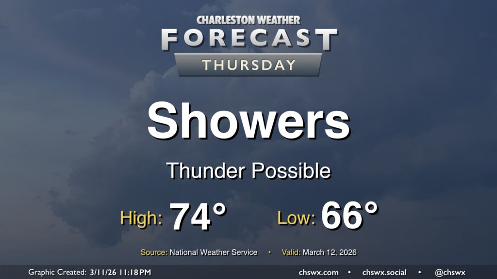
After a new daily record high of 89° was set at the airport on Wednesday, changes are forthcoming as we head into Thursday as a cold front approaches the area. We will start the day quite warm — record warm low temperatures are not out of the question — with lows in the mid-60s at coolest. Temperatures will then head into the mid-70s before a band of showers and thunderstorms approaches the area by mid-morning. Brief periods of heavy rain are possible, but storms will be moving quickly, so no concerns about too much rain in one location. Any rain we can get remains helpful as severe drought continues across the Lowcountry. There could be some thunder, too, and a few strong thunderstorm wind gusts can’t be totally ruled out as the line gets through.
The front will sweep the moisture and warm airmass offshore by evening, and temperatures will drop quickly into the 50s in its wake. If you are out and about Thursday evening, keeping a light jacket close by may not be the worst idea!
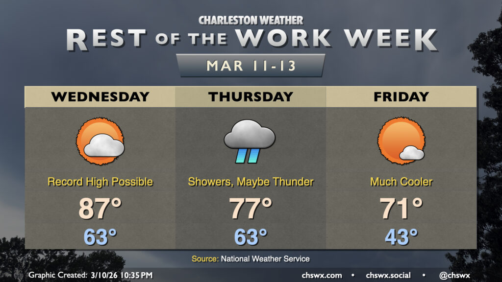
Another very warm day is on tap for Wednesday on the heels of the warmest day thus far in 2026. Wednesday’s forecast high of 87°, if it verifies, would break the daily record high for March 11 of 85° set in 2015. We’ll have plenty of sunshine for a good bit of the day, though cloud cover will tick up in the evening ahead of a cold front that will begin to restore a little order to a spring preview that’s gotten a bit out of hand.
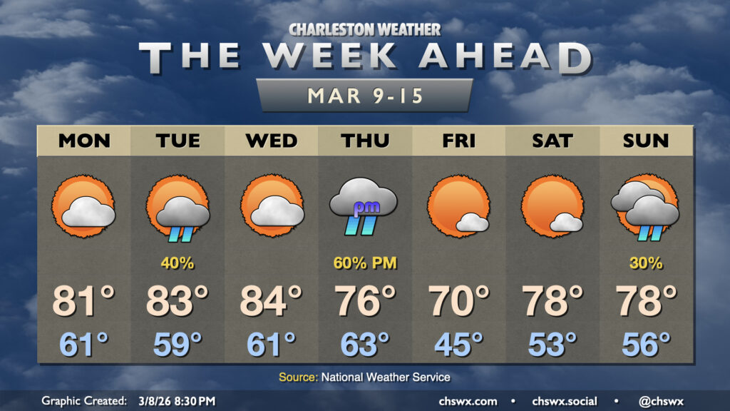
The stretch of abnormally warm, 80°+ days continues for the first half of the upcoming work week before a cold front knocks temperatures back a little bit as we head into the weekend.
Our stretch of early-March warmth continues for Friday and the weekend — and, realistically, well into next week — as stacked high pressure remains in place.
Generally quiet and rather warm weather continues for the rest of the work week. Wednesday morning will likely get off to a foggy start, with dense fog potentially reducing visibility to less than a quarter-mile at times. Use low beams and plenty of following distance in case you do encounter fog. Fog should erode by mid-morning, and we’ll head into the mid-70s under mostly sunny skies in the afternoon.
High pressure wedging down from the northeast overnight will set up a cool and mostly cloudy Monday across the Lowcountry — another dip on the temperature rollercoaster after an already up-and-down weekend. Temperatures start in the upper 40s with some fog possible (especially near the coast, where sea fog has been an issue), but the persistent northeast breeze and cloud cover courtesy of some moisture overrunning the wedge will keep temperatures pinned to the low 60s in the afternoon.
Showers have arrived in the Lowcountry and will be hanging around through much of Friday into early Saturday as a cold front lumbers through the area. We certainly could use the rain as severe drought continues over the Lowcountry, and 1-1.5″ of rain should fall in most spots through Saturday morning.
Lows on Friday will run on the warm side of normal; expect generally mid-50s across the area, while highs peak near normal in the mid-60s.
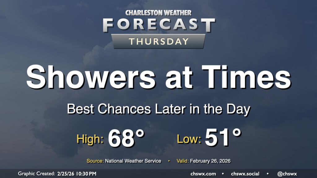
Showers return to the area on Thursday as energy aloft moves across the region ahead of a slow-moving cold front. The best chance for rain will arrive later in the day, and will stick with us into Friday. Temperatures Thursday start on a much more mild note — generally expect lows to fall to the low 50s in the morning, with highs peaking in the upper 60s in the afternoon.
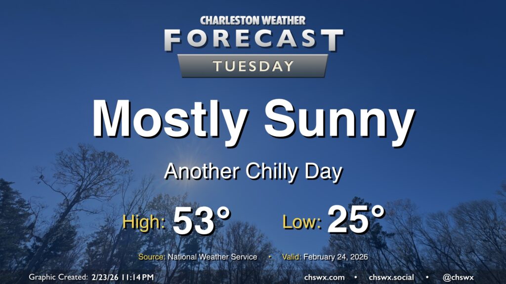
Our cold snap continues Tuesday as lows bottom out in the mid-20s in the morning. Winds will remain a touch elevated with the lingering pressure gradient between the high to our west and the nor’easter pulling away from New England, so wind chills will be a factor, perhaps briefly dipping into the teens (but not long enough for a Cold Weather Advisory, per NWS). Temperatures will run a few degrees warmer than they did on Monday, but that’s not saying much as Monday’s high only peaked around 48°. We can at least expect another day of mostly sunny skies with the cool and dry airmass still in place. Temperatures turn back up starting Wednesday as a cold front approaches the area; we should be in the 70s again by Thursday, and shower chances return for Friday.