Jared Smith founded @chswx on Twitter in 2008 as an experiment in disseminating weather data through social media. In the ensuing decade-and-a-half, @chswx has provided live coverage of tropical cyclones, tornadoes, severe weather, and even a couple bouts of winter weather to the good people of Charleston, SC.
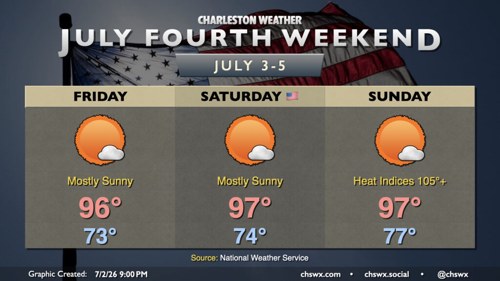
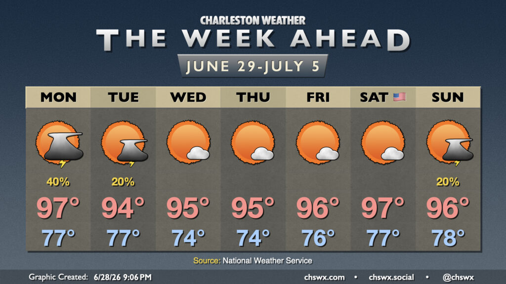
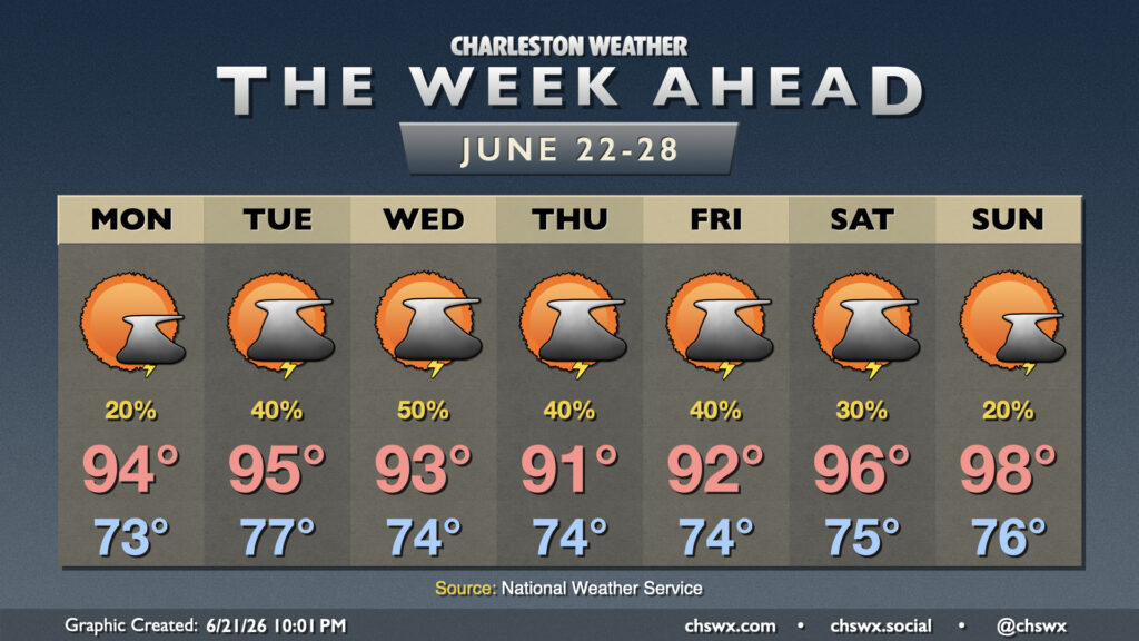
A hot and increasingly humid airmass will blanket the Lowcountry for the Fourth of July holiday weekend. Temperatures will run in the mid-90s each day, and with dewpoints climbing back into the 70s, heat indices will continue to escalate into the 100s, with the highest values each day being found in the Highway 17 corridor where the best overlap of dewpoints and air temperatures will be found. Heat indices will peak around 100-101° on Friday, 102-106° on Saturday, and should approach the Heat Advisory threshold of 108° on Sunday. Nights will impart increasingly less relief, too, with lows climbing into the upper 70s to around 80° by Sunday, warmest near the coast and in downtown Charleston. The warm nights will compound heat stress, especially for folks who don’t have adequate cooling, which is why it’s so important to take it easy during these hot stretches.
If you’re looking for thunderstorms to cool things off, I wouldn’t really count on those either. The atmosphere should stay capped Friday and Saturday, with a slightly better chance for a stray storm on Sunday but still low enough of a chance as to be technically unmentionable (~10%). If a storm can kick off, watch for frequent lightning and gusty winds. With that being said, the vast majority of us should get a rain-free holiday weekend in.
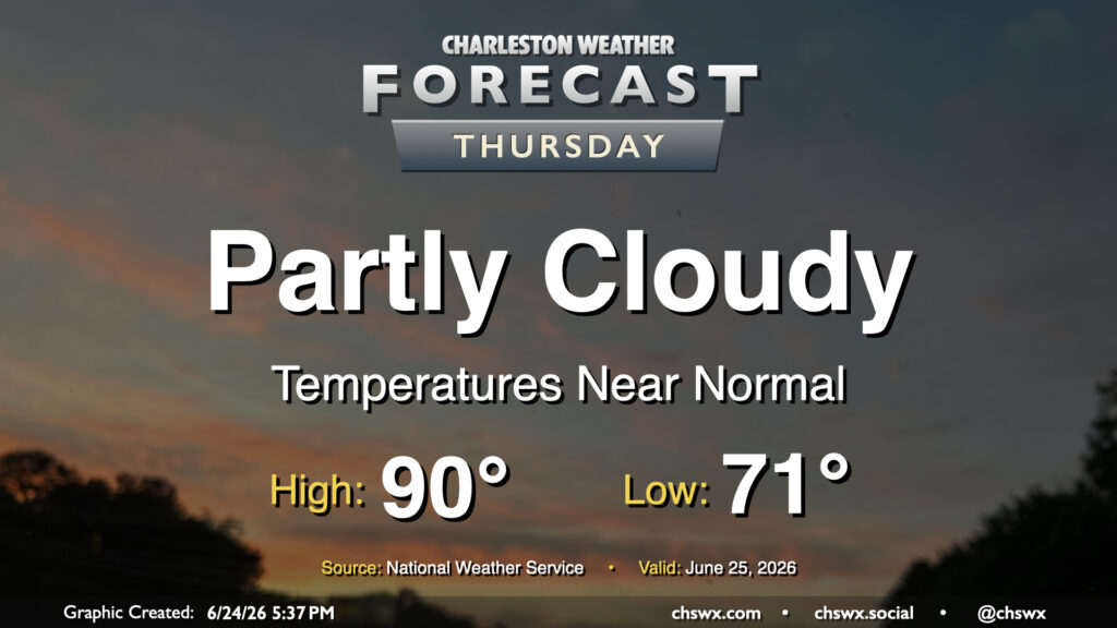
High pressure continues to dominate the weather pattern, which keeps things toasty and rain-free for Thursday. Fortunately, drier air will still be in place for one more day, which will allow for lows to drop to the low 70s in the morning. From there, we’ll warm to the mid-90s in the afternoon. Dewpoints will mix down to the mid-60s, keeping heat indices within a degree or two of the air temperature. It’ll still be plenty hot, but a drier heat will be appreciated.
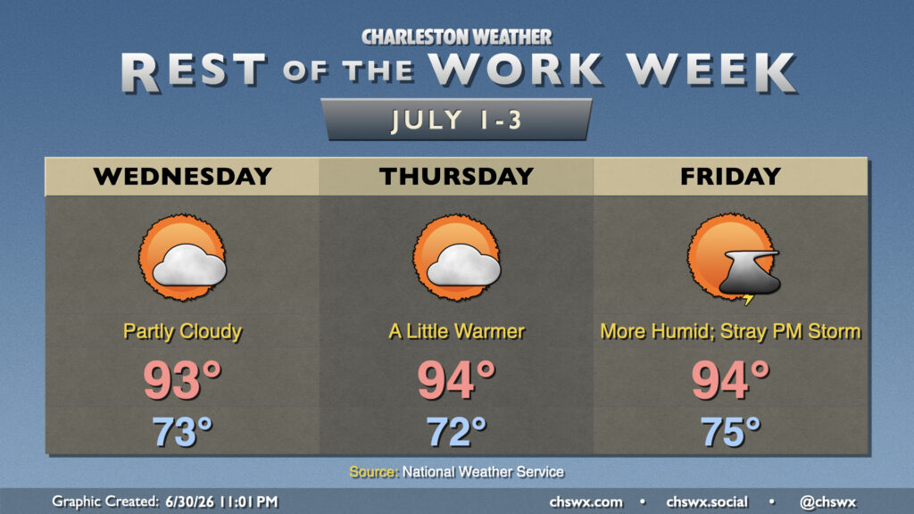
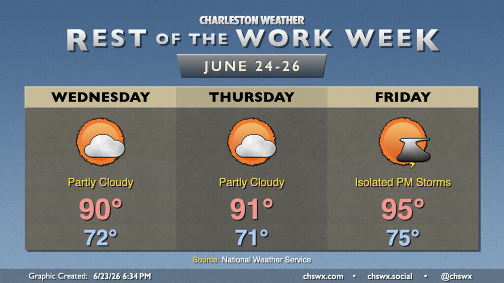
High pressure remains the primary weather driver at the surface and aloft for the rest of the work week, keeping temperatures toasty. Northeast flow over the next couple days, though, helps to bring in some drier air, which will keep heat indices from popping off too much. Wednesday starts in the low-to-mid-70s, with temperatures warming into the low to mid-90s in the afternoon under generally partly cloudy skies. The aforementioned stacked high pressure and influx of drier air will keep convection to a minimum.
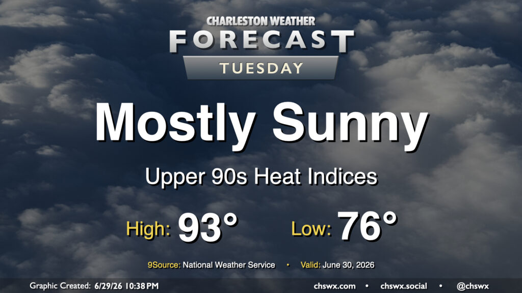
High pressure wedging southward into the Lowcountry and the resulting northeasterly flow will take a slight edge off the heat for Tuesday after another day in the mid-90s on Monday. It’ll still be a steamy start, though, and the low of 78° will get awfully close to the record warm low temperature of 79° set in 2024. We’ll warm into the low 90s in the afternoon, but dewpoints running in the low to mid-70s will drive the heat index into the upper 90s (standing in contrast to the mid-100s we’ve felt the past few days). High pressure ridging in aloft will put a lid on thunderstorm activity, though some of the convection-allowing models still try to squeeze out a few showers in the afternoon. Rain is highly unlikely, though, so don’t count on it.
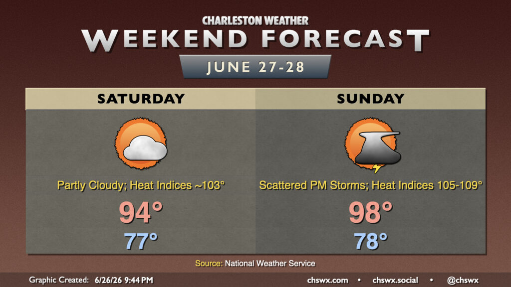
A hot weekend is ahead, especially on Sunday, as high pressure builds in aloft. A few of us could get some relief from a few thunderstorms, but that’s not a guarantee for everyone.
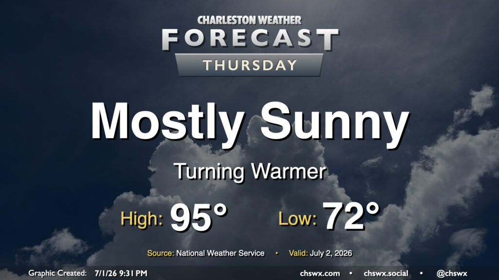
Another quiet day is on tap for Thursday with high pressure in control. Lows bottom out in the low 70s, warming to around 90° in the afternoon. Dry air (for this time of year, anyway) will hang on for one more day, though it will be a bit more humid than it was on Wednesday. High pressure and warm air aloft should keep a lid on thunderstorms for one more day as well.
Generally normal summer weather continues for the rest of the work week, with a bit of an uptick in temperature as we head into Friday and the weekend.
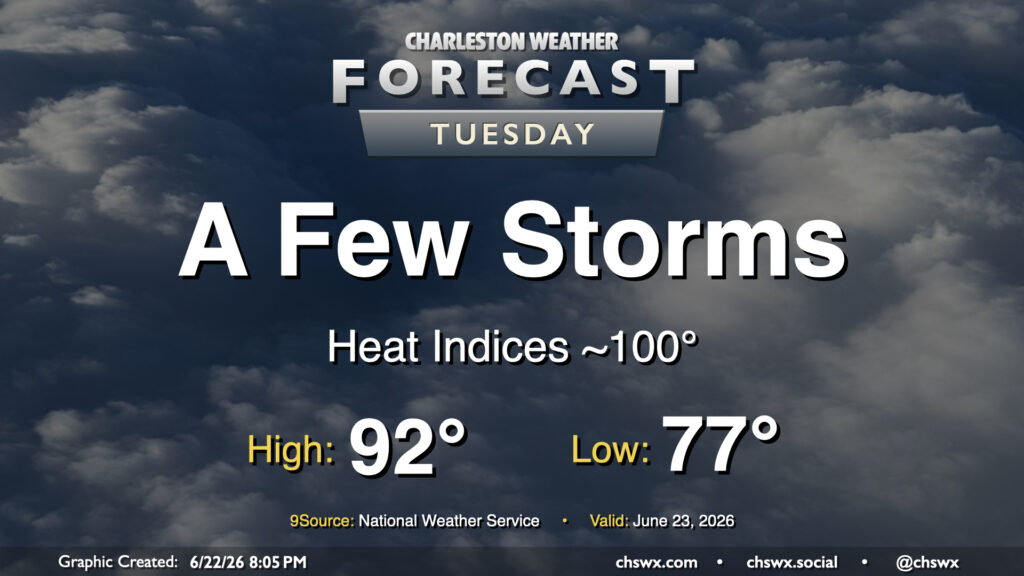
Standard summertime fare continues in the forecast for Tuesday with seasonably warm temperatures and a few afternoon thunderstorms. We’ll start the day on the warm side of normal ahead of a stalling cold front, with lows in the mid-to-upper 70s. The record warm low temperature at the airport for June 23 is 78°, set in 2024, and we may get close to that. From there, we’ll warm into the low 90s, but dewpoints in the low 70s will drive heat indices to around 100° at peak heating. We should see a few storms fire along and head of the seabreeze in the afternoon, though the convection-allowing models are rather sparse with coverage. If storms get going, there are some indications that a pocket of dry air in the mid-levels could help produce some gusty winds in addition to the usual heavy rain and lightning threat, so be alert for possible special weather statements or even warnings.