Weekend forecast: Unsettled end to our recent warm spell
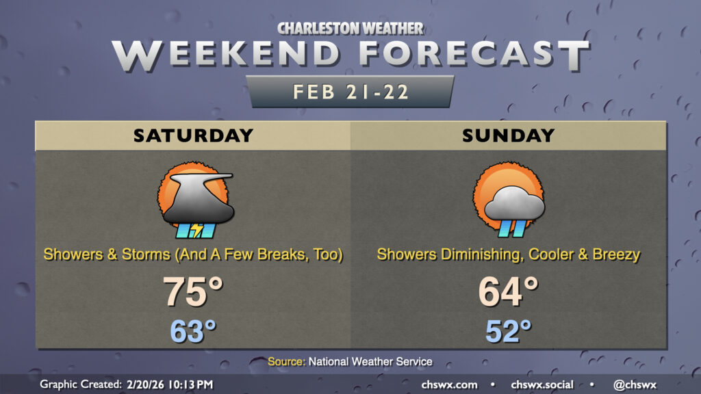
Our run of warm temperatures, which peaked Friday with a record-tying high of 82° at the airport, will be coming to an end this weekend as a storm system affects the area.
Read more »Our run of warm temperatures, which peaked Friday with a record-tying high of 82° at the airport, will be coming to an end this weekend as a storm system affects the area.
Read more »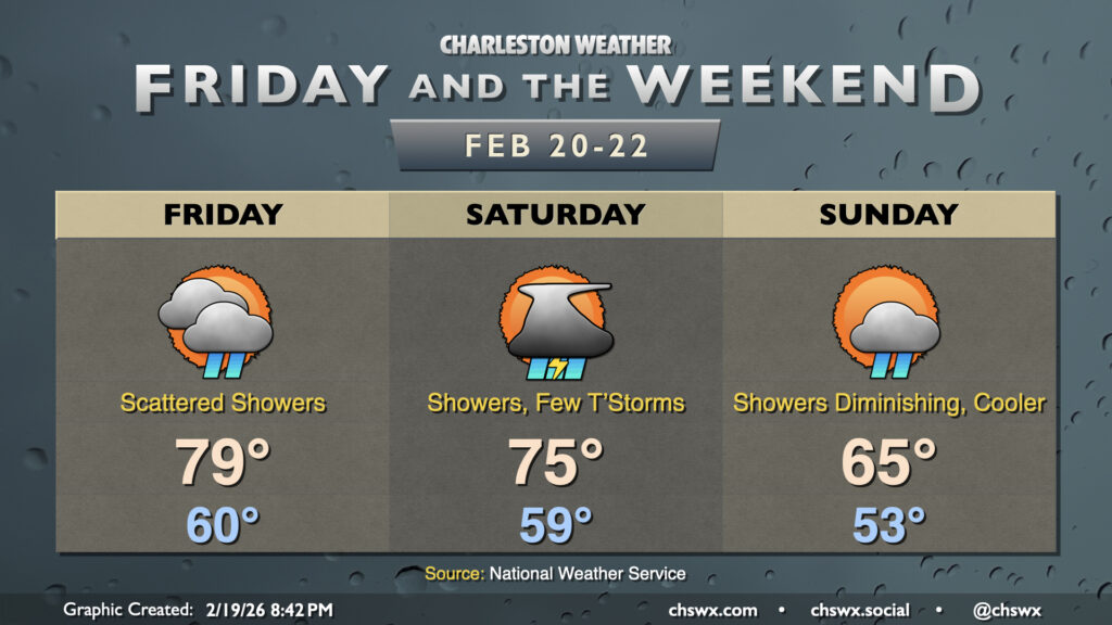
The warm spell peaks on Friday before a cold front affects the area over the weekend. The first 80° day of 2026 is not out of the question on Friday, though a scattering of showers will potentially put a damper on that possibility, especially heading into the afternoon. Like the past couple days, another breezy day looks to be on tap as well, with winds gusting 25-30 MPH at times as the heating of the day helps tap into somewhat stronger winds aloft. As for showers, they aren’t out of the question really at any point in the day, though coverage should increase a bit getting later into the afternoon as the cold front stalls out across the Upstate and Midlands. Not expecting too much in the way of rainfall amounts on Friday, though some brief downpours aren’t out of the question, especially inland from the coast where a little more instability may exist.
Read more »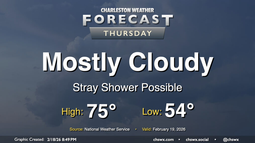
We’ll see more in the way of cloud cover and maybe even a few showers on Thursday, but that won’t stop temperatures from getting back to the mid-70s after a warm-for-February start in the mid-50s. Deep southwesterly flow will continue to pump warm and moist air into the area, and as temperatures warm into the 70s, this could spawn a few popup showers (not something we often say in February!) along with gusts around 20-25 MPH.
Read more »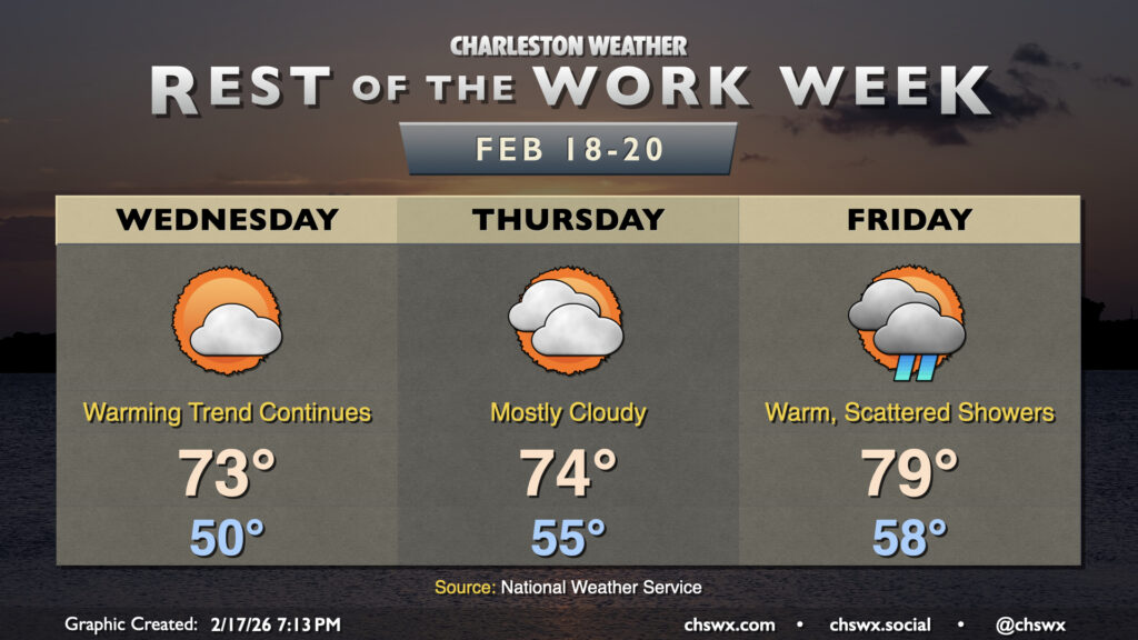
After a fairly warm day (away from the coast, anyway, where temperatures ran some 10°+ cooler), we’ll turn even warmer on Wednesday as high pressure slips offshore, pumping in warmer air from the south and southwest. Wednesday starts around 50° with perhaps a few patches of fog, and we’ll warm well into the low-to-mid-70s under a mix of sun and clouds. Winds will be a bit breezy out of the southwest, generally around 10-15 MPH during the afternoon as mixing from daytime heating taps into 25-30 MPH winds a few thousand feet off the deck.
Read more »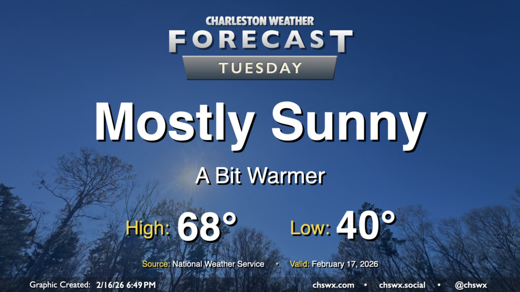
A warming trend kicks off Tuesday as high pressure moves overhead and eventually offshore. It’ll be quite a nice day after we start around 40° in the morning; temperatures will head well into the 60s by afternoon with plenty of sunshine to be had and comfortable relative humidity values. Winds won’t be quite as strong as they were on Monday, either, with speeds generally around 5 MPH. Winds will shift around to the southeast as high pressure slips into the Atlantic, a harbinger of warmer air to come.
Read more »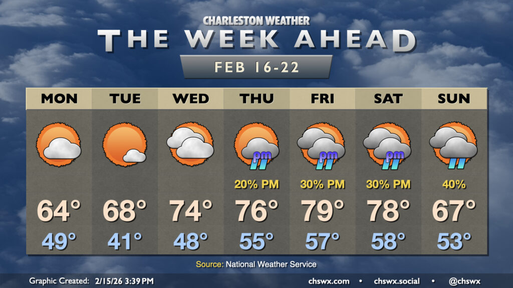
After some much-needed rain on Sunday, sunshine and warmth return for the new work week as high pressure remains the main weather driver for a few days before shower chances return to the picture later in the week.
Read more »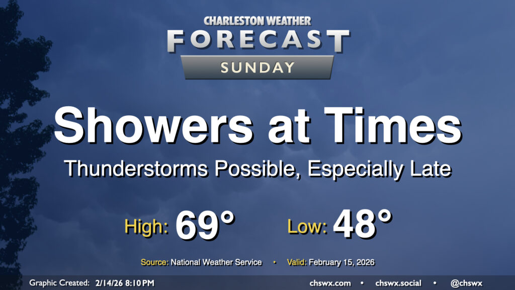
A storm system will affect the area on Sunday, bringing us some showers at times and maybe even a few thunderstorms as we get into the afternoon and evening hours. We need the rain as moderate drought continues to envelop the area, and a half-inch to even an inch of rain will be possible. While that won’t put an end to the drought by any stretch, it will certainly help.
Read more »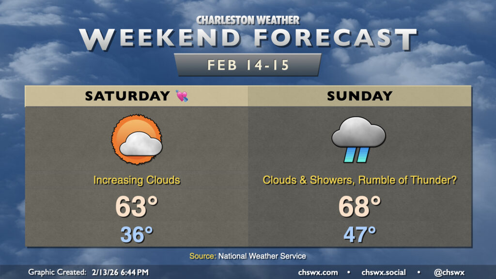
While Valentine’s Day looks lovely, Sunday will decidedly not live up to its name as a storm system affects the area. From there, quite a warming trend develops, especially for the second half of next week.
Read more »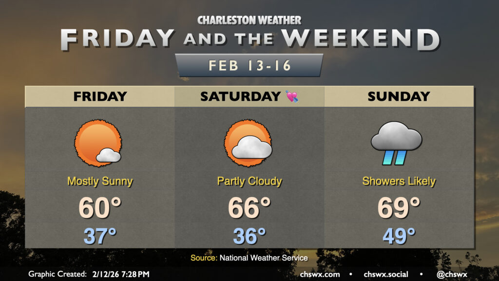
Another quiet and generally seasonably pleasant day is head on Friday. We get off to a bit of a chilly start as lows fall to the mid-to-upper 30s in the morning. A northeasterly breeze will make it feel closer to freezing to start the day, but temperatures will warm to around 60° in the afternoon under predominantly sunny skies. This is a few degrees below mid-February norms, but nothing too outrageous.
Read more »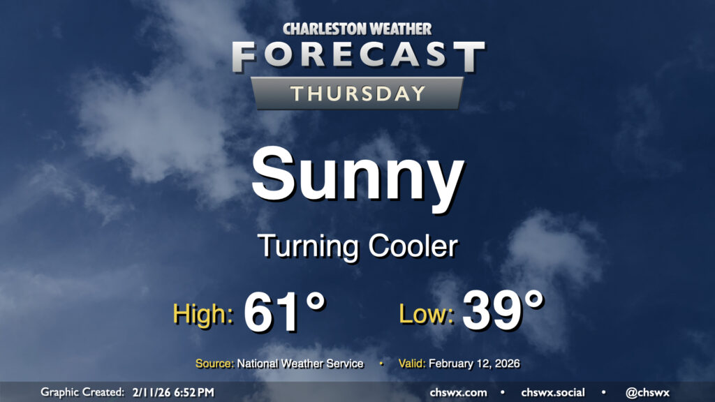
After a front gets through overnight, we’ll turn cooler for Thursday as temperatures head ever-so-slightly below normal. We’ll start Thursday in the upper 30s to around 40°, warming to the low 60s in the afternoon under predominantly sunny skies. While not quite the 70s, it’ll still be a solid mid-February day in the Lowcountry.
Read more »