Jared Smith founded @chswx on Twitter in 2008 as an experiment in disseminating weather data through social media. In the ensuing decade-and-a-half, @chswx has provided live coverage of tropical cyclones, tornadoes, severe weather, and even a couple bouts of winter weather to the good people of Charleston, SC.
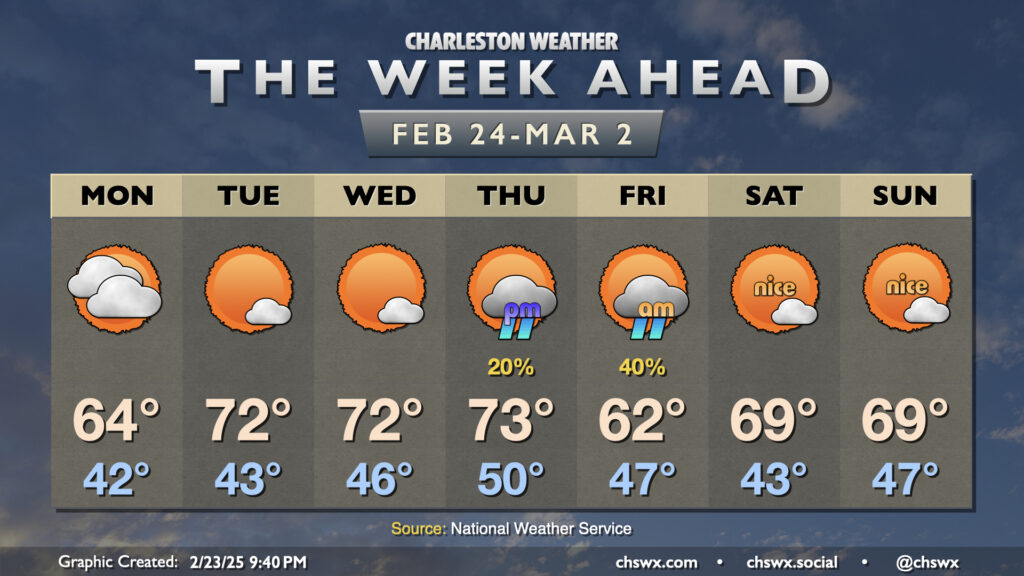
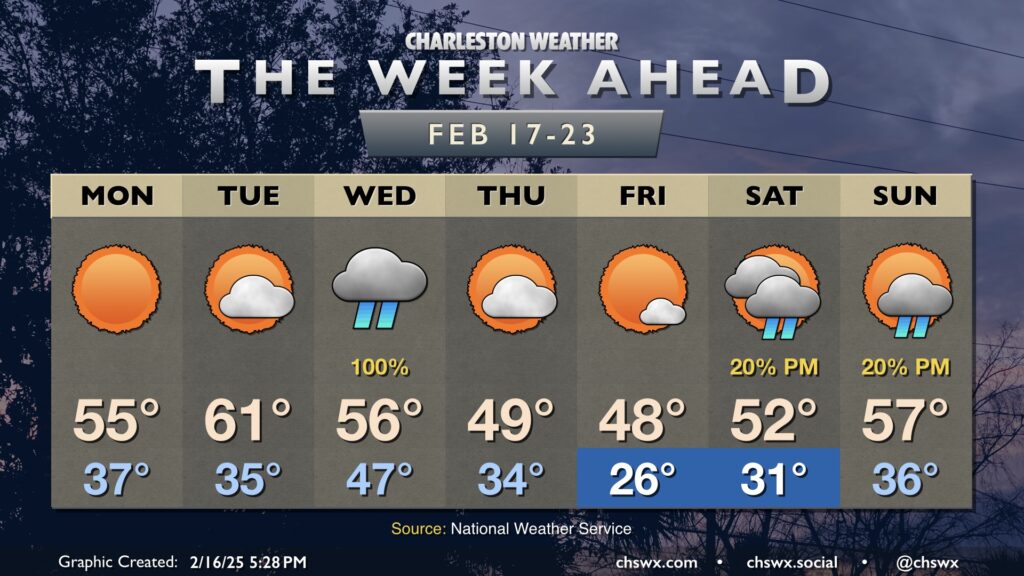
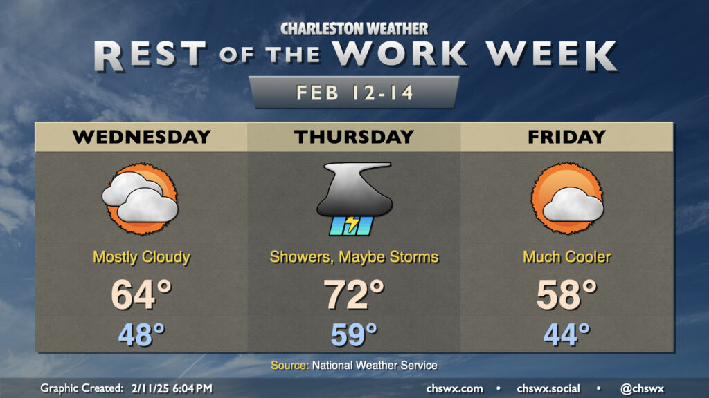
Climatological winter, which runs from December 1 to February 28 (or 29th, depending on the year) will end on a very spring-like note this week as temperatures head back above normal starting mid-week and beyond (with the exception of Friday, when a front comes by with a minor shot of cooler air).
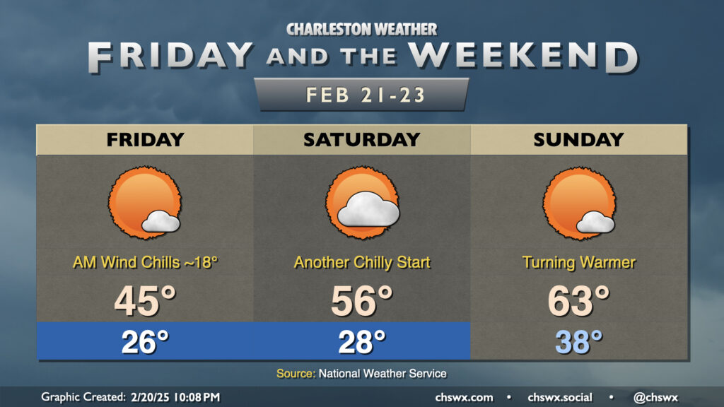
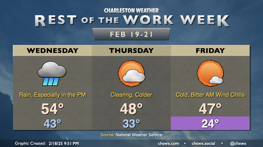
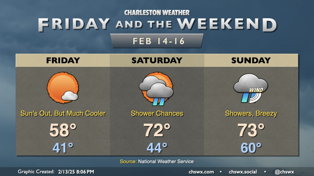
After a chilly and dreary Thursday where temperatures barely got up to the low 40s, we’ll at least see the sun on Friday. Still, though, it’s going to be very chilly, with lows in the mid-20s and wind chills in the mid-to-upper teens to start the day, warming only to the mid-40s in the afternoon despite that additional sunshine. In fact, we’re in line to break the daily cold high temperature record of 47° set on February 21, 2020 as highs are set to peak just in the mid-40s.
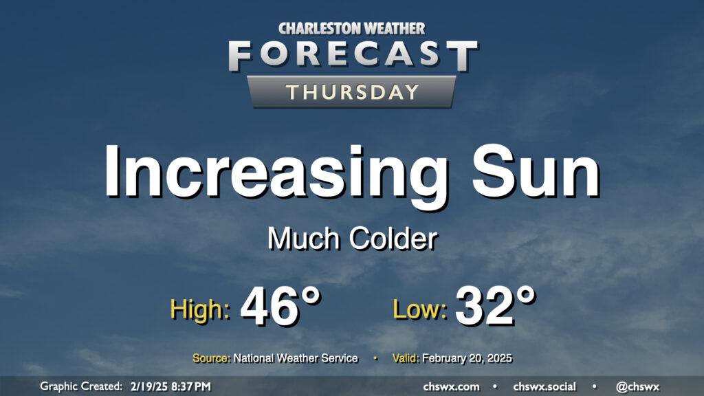
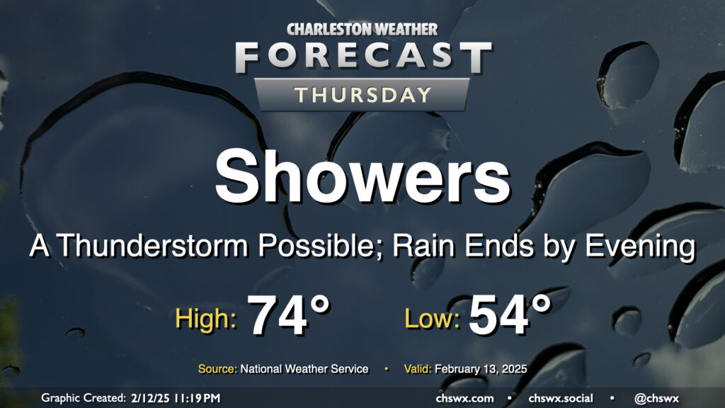
Clouds will thin out throughout the day Thursday as colder and drier air pours into the area from the northwest. We’ll start the day around freezing, warming to just the mid-40s in the afternoon despite the increasingly sunny skies. The last time we had a high temperature this cold was January 24, when the high was only 47° courtesy of 2″ of snow still on the ground from the 1/22 snowstorm. (The record cold high temperature of 39°, set in 2015, will remain intact, thankfully.)
Unsettled weather is expected on Wednesday as a potent storm system brings us a good bit of much-needed rain, particularly in the afternoon into the evening. Lows start in the mid-40s, warming just to the mid-50s in the afternoon owing to the rain-cooled state of play. If you have travels taking you northward into the Midlands and beyond, there’s a risk for some winter weather as well, especially getting into NC and VA where ice and snow will be the rule. There will be too much warm air in our neck of the woods for any winter weather, and I suspect that is probably okay with many of you!
The week ahead will be notable for the return of cooler-than-normal temperatures to the forecast, especially after a mid-week storm system moves by which will send morning lows below freezing for the first time since the mid-January snowstorm.
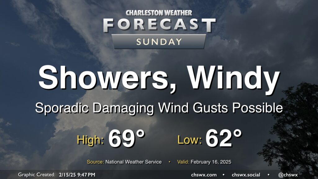
Sunday will be a very breezy day as a highly dynamic storm system moves across the eastern half of the continental United States. Showers and a few thunderstorms should set up in a line ahead of a cold front which will come through generally between 11am and 1pm, according to NWS. The line of showers and storms could produce damaging wind gusts to 60 MPH, which could prompt some Severe Thunderstorm Warnings for tree damage and possible power outages. Even outside of storms, gusts 40+ MPH will be possible, especially on bridges and overpasses. A Wind Advisory goes into effect overnight through about 5PM.
Rain will be offshore by evening, and winds will die down as the front clears the area. This will set up a much cooler week ahead, with a mid-week secondary front likely to send us back below freezing for the first time since the January snow later in the week.
A cold front that brought showers and a few thunderstorms to the Lowcountry — including a tornado warning for Hilton Head Island — is through the area, and we’ll start Friday on a much cooler note as a result. Expect lows in the low 40s Friday morning, warming only to the upper 50s in the afternoon despite much more sunshine.
A warm front will lift north of the area overnight, scouring out some dense fog and sending much warmer and more humid air into the area ahead of an approaching cold front. Within the warm sector, we’ll start in the mid-50s, warming to the mid-70s early on before a line of showers and maybe a few thunderstorms approaches the area, generally affecting the metro between 10am-4pm. Severe weather is unlikely this far north where instability is a bit more meager, but a rumble of thunder or two with a strong wind gust is still not totally out of the question. You won’t need the rain gear all day, though, as storms should be offshore by evening with the front following thereafter.
The temperature rollercoaster takes another upswing Wednesday and Thursday before dipping again Friday as a series of fronts affect the area.
Astute @chswx readers will note that Wednesday’s forecast high is about 10° cooler than the 74° that was advertised yesterday. High-resolution model guidance is strongly suggestive that the wedge front will take longer to move northward across the area as a warm front than previously thought. In fact, there’s some indications that it may stall out right across the Tri-County for a time, which certainly makes for a tricky temperature forecast. Right now, the going forecast is the mid-60s with mostly cloudy skies expected.
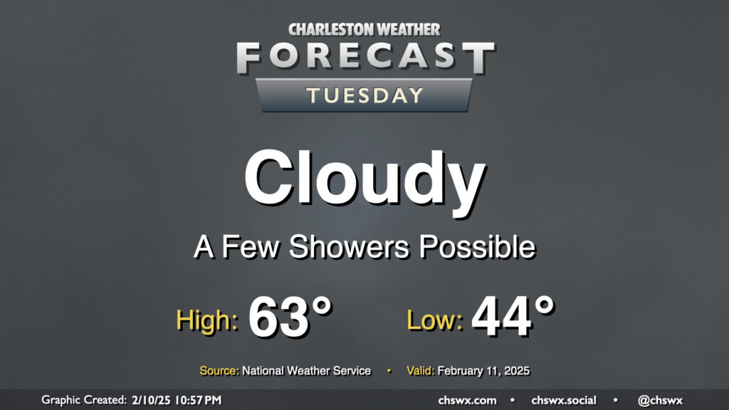
A wedge of cool high pressure hangs tough on Tuesday, bringing another gray and cool day to the area. Temperatures start in the mid-40s, warming to the low 60s in the afternoon — right around normal for this point in February. There’s going to be a risk for some showers from time to time, but an all-day rain isn’t expected.