Jared Smith founded @chswx on Twitter in 2008 as an experiment in disseminating weather data through social media. In the ensuing decade-and-a-half, @chswx has provided live coverage of tropical cyclones, tornadoes, severe weather, and even a couple bouts of winter weather to the good people of Charleston, SC.
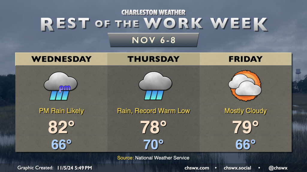
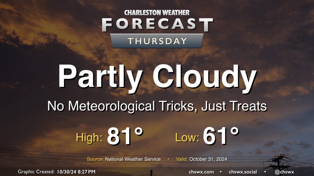
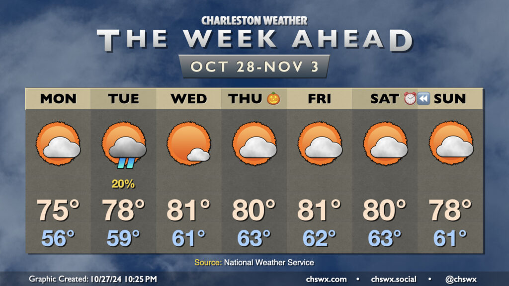
Many stations recorded a good bit of measurable rainfall yesterday, and it looks like we have another round of it coming Wednesday evening into Thursday courtesy of the interaction of Tropical Storm Rafael in the Gulf and a cold front. Meanwhile, the airmass remains awfully tropical for early November, and we should set a new record warm low temperature on Thursday as a result.
Wednesday will start out quiet and mild (mid-60s lows expected), but expect showers to increase across the area as we get into the afternoon and evening hours, including around the evening commute. Temperatures top out in the low 80s before rain overtakes the area. We could even hear some rumbles of thunder thanks to the spring-like dewpoints around 70-72°.
Rain continues on Thursday and should be around for much of the day. We start the day around 70° — which would be a record warm low for the date — and warm only to around the upper 70s given the cloud cover and ongoing rainfall. Many spots will end up with 1-2″ of rain before this is over, with even higher amounts possible west of 26. It’s much-needed rain, and given that it’s been so dry, the flooding risk is low (provided pockets of heavier rain don’t train over the same urban areas).
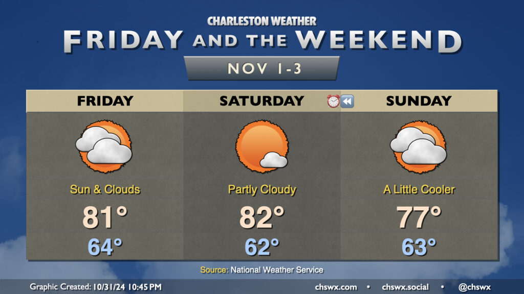
High pressure builds back in for Friday and into the weekend, giving us a chance to dry out. Warmer-than-normal temperatures will persist, with highs in the upper 70s to low 80s continuing each day well into next week.
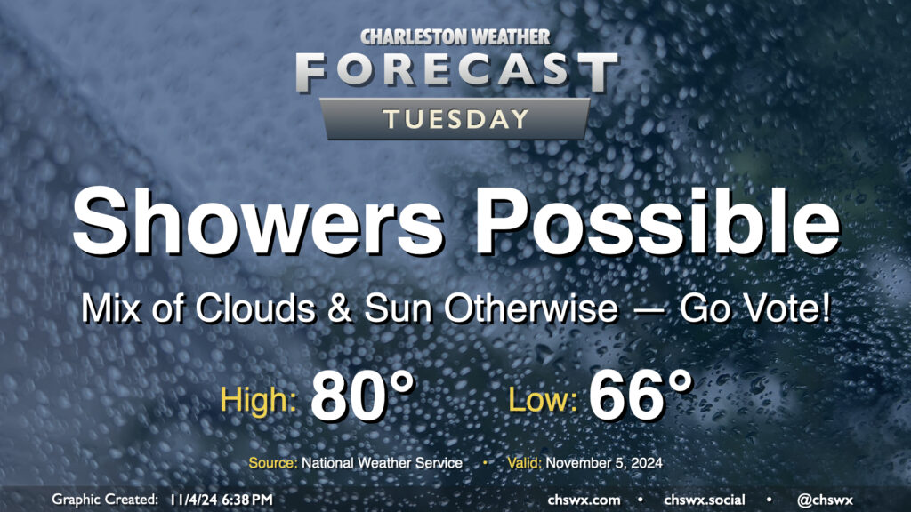
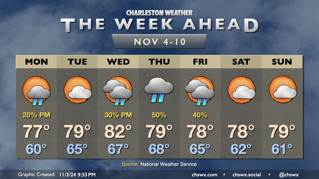
A few showers will be in the cards as we head to the polls for Election Day on Tuesday, but it won’t be a washout and should be minimally disruptive to voting. We start the day about 15° above normal with lows in the mid-60s, warming to 80° in the afternoon. We’ll see some peeks of sun from time to time as well. Go out and make your voice heard!
The main story of the upcoming week of weather will be the potential for some actually measurable rainfall especially as we get into midweek. Temperatures will remain above normal, though, in a blow to sweater weather fans across the Lowcountry.
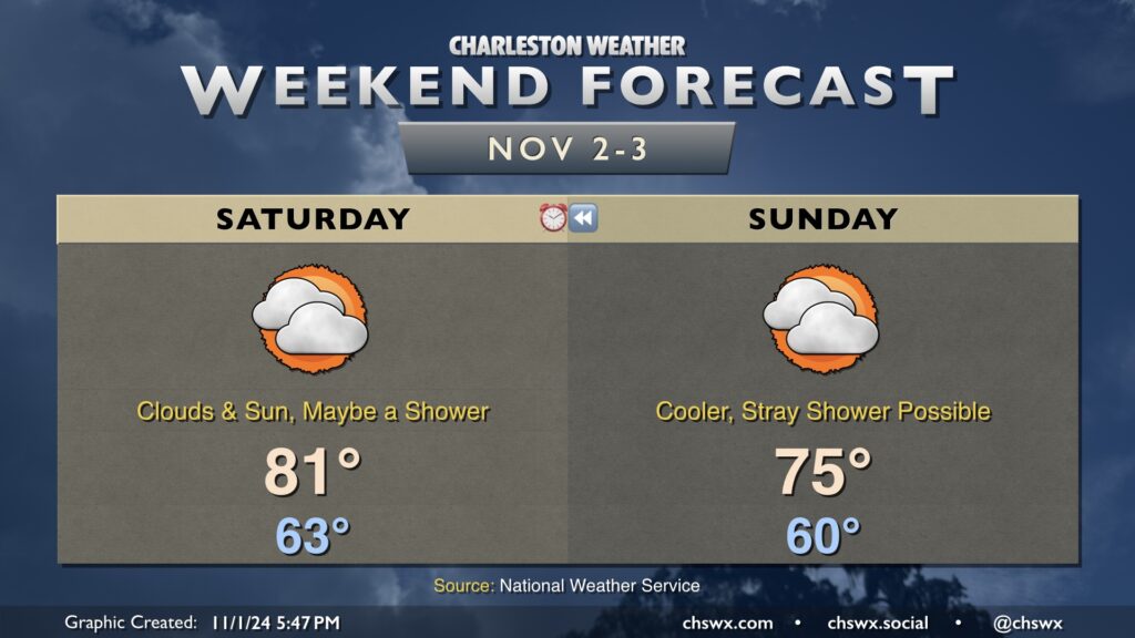
Unseasonable warmth continues on Saturday ahead of a front that will move south across the area late in the day. As has been the case the past few days, there will be a decent mix of cloud cover with sunshine at times as well. A stray shower can’t be totally discounted, but much of us should stay rain-free as the drought continues. Lows on Saturday start in the low 60s, warming to the low 80s in the afternoon.
Sunday runs a little cooler as high pressure wedges southward. We start the day around 60° and warm to the mid-70s in the afternoon — still above normal, but not quite as above-normal as we’ve seen temperatures go recently. A mix of clouds and sun continues to be expected, and a stray shower is still not totally out of the question. Measurable rainfall looks highly unlikely, though.
Finally, don’t forget: we fall back to Standard Time early Sunday morning. Take Saturday evening to move the manual clocks backwards, check the batteries in your smoke detector, and maybe give your NOAA Weather Radio a once-over, too.
Unseasonable warmth rolls right into November as temperatures for Friday and Saturday remain upwards of 8-10° above normal for the start of the final month of hurricane season before a front cools things off slightly for Sunday. Overall, expect highs in the 80s on Friday and Saturday after starts in the low to mid-60s. A mix of sun and clouds will continue across the area, with perhaps a bit more sunshine on Saturday before a backdoor front moves by on Sunday, cooling us off a few degrees and thickening cloud cover once more.
Measurable rainfall remains extraordinarily difficult to come by; a few spots have had some sprinkles from time to time, but that’s about it. In fact, October 2024 is going to go down as the second-driest October on record with only 0.03″ of rain measured at the airport on October 4, and only traces of rain on a few occasions since then. This is second only to October 2000, when only a trace of rain was recorded that month. Records at the North Charleston climate site at the airport go back to 1937. As you can imagine, drought is developing over the area, and this week’s Drought Monitor puts much of the Lowcountry into moderate drought, while the rest of the state (except for a sliver of Lancaster and York counties) is now into Abnormally Dry conditions. We could certainly use a bit of rain, and none seems likely through at least the middle of next week.
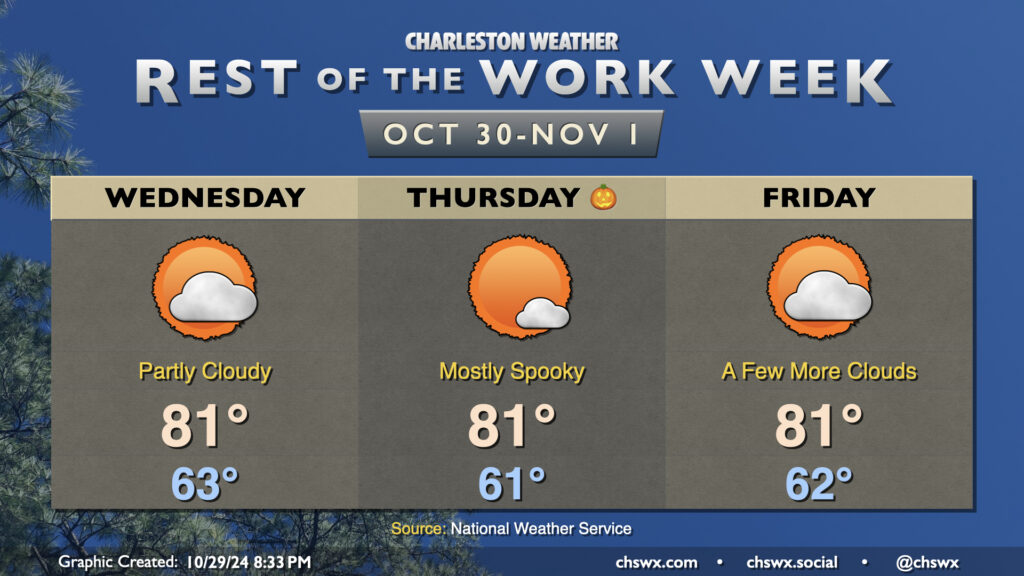
Expect quiet weather for Halloween this go-around as high pressure remains the dominant weather feature across the Lowcountry. It’ll be a mild one this year as temperatures start in the low 60s, warming to the low 80s in the afternoon under partly cloudy skies. The only concern may be if costumes run a little warm!
We’ll keep this going into the weekend. Maybe a shower Friday, but otherwise quiet weather continues with upper 70s to low 80s for highs each afternoon.
After a coastal trough pushed ashore with a trace of rain (or more in a few lucky spots), the weather turns quiet once again on Wednesday, with another stretch of dry weather expected well into next week. We start the day in the low 60s, with temperatures warming back to the low 80s in the afternoon under partly cloudy skies. We’ll copy, paste, and delete a few clouds for Halloween, starting once again in the low 60s and warming to the low 80s in the afternoon. A few more clouds kick up for Friday ahead of a weakening front, but otherwise, temperatures do the same ol’ thing — low 60s to start, low 80s in the afternoon.
A small cooldown arrives this weekend, but that’ll take temperatures down from the low 80s to the upper 70s — definitely not a return to more seasonable weather, much less any sweater weather. The Climate Prediction Center continues to favor warmer than normal weather over the next couple weeks, while above-normal precipitation is a possibility heading into the second week of November. Stay tuned on that, though.
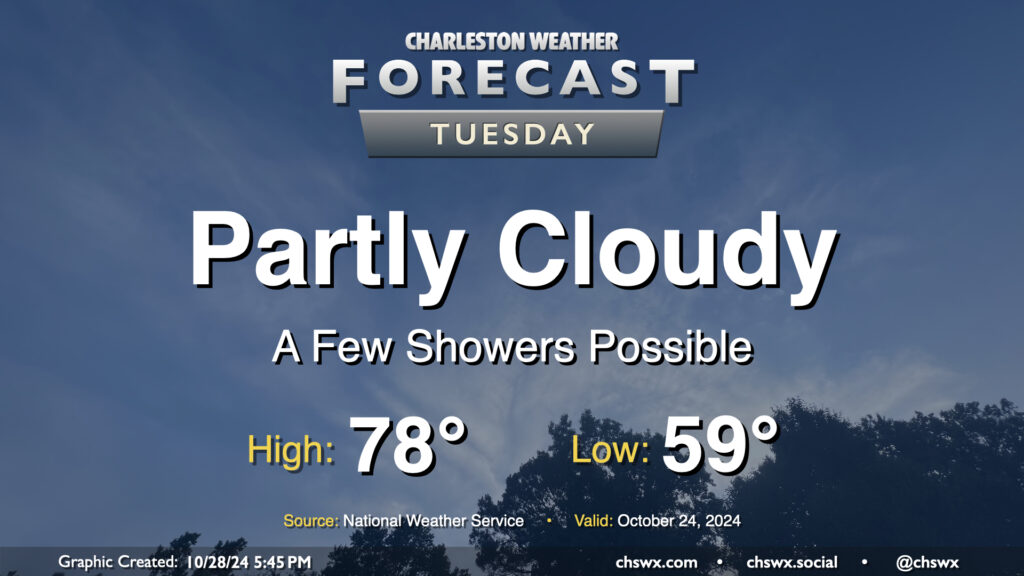
A surface trough will push inland Tuesday, and this could spread a few showers ashore throughout the day. Rain chances are pretty small, though, given the continued dry conditions, and any rain that does fall probably will not amount to a whole heck of a lot. Rain chances diminish by evening. Otherwise, expect partly cloudy skies. Temperatures will begin to trend back above normal, with upper 50s in the morning yielding to highs in the upper 70s in the afternoon.
A cool wedge of high pressure knocked temperatures down into the 60s on Sunday afternoon, but we should see temperatures begin to recover starting Monday, with above-normal temperatures favored for much of the upcoming week.
Cloud cover will scour out throughout the day Monday as ridging builds back in aloft. We’ll still be under the influence of the cool wedge of high pressure, which will keep highs right around the normal mark of 75° for late October after a mid-50s start.
Rain chances remain essentially nil this week, save for Tuesday, when a coastal trough could spread some light showers ashore. Much of us should stay dry, with measurable rainfall not looking like a great bet given the antecedent dry conditions. Highs on Tuesday head a few degrees above normal, back into the upper 70s after an upper 50s start.
The weather remains dry and much warmer than normal as we close October and start November. Expect highs in the 80s each afternoon starting Wednesday through at least Saturday with seasonably mild starts in the low 60s each morning as high pressure continues to be the primary weather feature. Skies will generally be partly cloudy each day. Suffice to say, we’ve got no weather concerns for trick-or-treaters this year. A front slips by over the weekend with a slight cooldown, but moisture appears to remain at a premium, keeping rain chances virtually nil.
Finally, we fall back to Standard Time this weekend. The morning daylight will be a little more in whack with sunrises before 7am until late November, but we’re back to “dark when we leave work” season once again. We’ll go from a 6:27 PM sunset on Saturday to a 5:26 PM sunset on Sunday. We continue to lose daylight until the winter solstice on December 21.
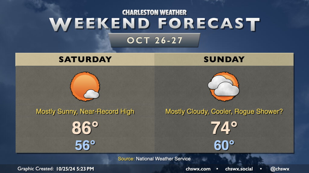
We’ll look to approach a record high on Saturday before a cold front swings through Sunday, cooling us off a bit and increasing cloud cover. (A shower or two may not be out of the question, either.)
High pressure at the surface and aloft hangs on for one more day on Saturday. We start the day in the mid-50s, but compressional heating ahead of the aforementioned front will help drive temperatures into the mid-80s. The record high of 87°, set in 1939, may be achievable at North Charleston, so we’ll keep an eye on this. A few clouds are possible, but sunshine should be the dominant feature once again.
Sunday will feature more clouds than we’ve seen in a while as the ridge moves out and a trough moves in overhead, driving a backdoor front through the region. We start around 60°, but only warm to 74° in the afternoon as winds shift northeasterly. Model guidance still does not totally rule out a shower or two across the Tri-County on Sunday, but most of us should expect the day to stay rain-free. Any rain that falls would be largely insignificant, too, perhaps in the hundredths of inches at best, so definitely not anything to get your hopes up over (if rain’s what you’re looking for, anyway).
Heading into next week, we stay cool for Monday but start to warm up again on Tuesday and beyond. Halloween will be on the warm side with lows in the low 60s warming to around 80° in the afternoon under mostly sunny skies. Alas, no sweater weather is in the foreseeable future as we head into November.