Jared Smith founded @chswx on Twitter in 2008 as an experiment in disseminating weather data through social media. In the ensuing decade-and-a-half, @chswx has provided live coverage of tropical cyclones, tornadoes, severe weather, and even a couple bouts of winter weather to the good people of Charleston, SC.
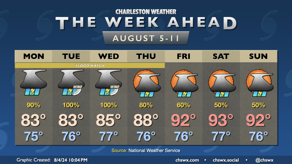
While Debby shuffles off to the northeast, our weather will remain unsettled as a trough persists aloft across the eastern half of the country. This will drive a surface front just close enough to stall out and keep elevated shower and thunderstorm chances in play each afternoon.
We returned to the 90s on Thursday and will head back there each afternoon for the foreseeable future. Lingering tropical moisture in the wake of Debby will help drive heat indices well into the 100s, perhaps flirting with advisory criteria despite low 90s air temperatures. Then, we should see showers and thunderstorms fire up each afternoon generally along and ahead of the seabreeze. Storm motions will generally be eastward, so some rain could spread to the coast.
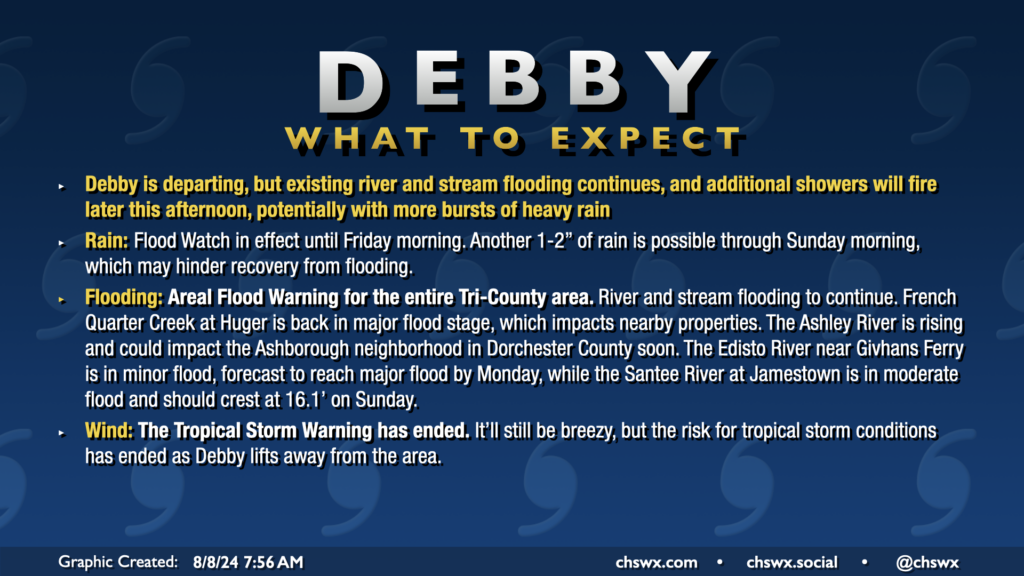
All Tropical Storm Warnings were dropped this morning as Debby, which made landfall around Bulls Bay at 2am, continues to lift north away from the area. The risk for flooding continues, especially near rivers, creeks, and streams. An Areal Flood Warning remains in effect across the entire Tri-County area through at least 2:45pm. Additional rain should develop courtesy of some wraparound moisture from Debby as we get into the heat of the day, which could inhibit recovery from flooding, so the warning continues. The Flood Watch continues until Friday morning as well.
Temperatures today will run in the upper 80s, closer to normal after a record cool high temperature of 80° on Wednesday. We’ve seen some peeks of sun and blue sky this morning and should hopefully see a bit more of that just for our spirits’ sake. The sun will make a more complete comeback for Friday and the weekend.
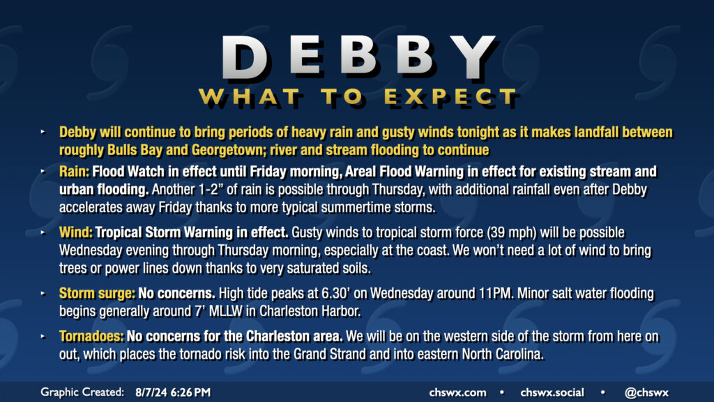
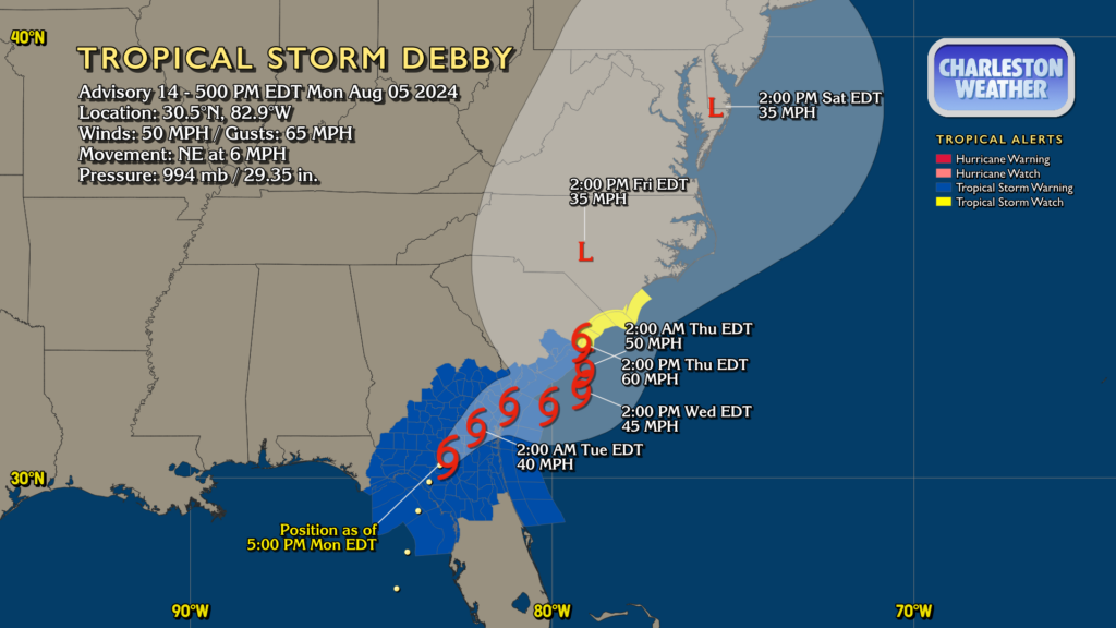
Tropical Storm Debby will make landfall on the South Carolina coast somewhere around Bulls Bay up to Georgetown (taking the cone literally, the margin for error is between Mt. Pleasant and Myrtle Beach) overnight as it turns northward in response to high pressure building back in from the east. This landfall likely won’t really come with much fanfare as Debby’s inner core was hollowed out by land interaction and dry air over the past day or so. The strongest winds, in fact, are well away from the center of the storm. Still, there’s a risk for tropical storm-force winds at the coast and within gusts in rain bands, so the Tropical Storm Warning continues. With such saturated soils, it won’t take too much in the way of wind to bring trees down, so we’ll want to stay a little vigilant about possible power outages.
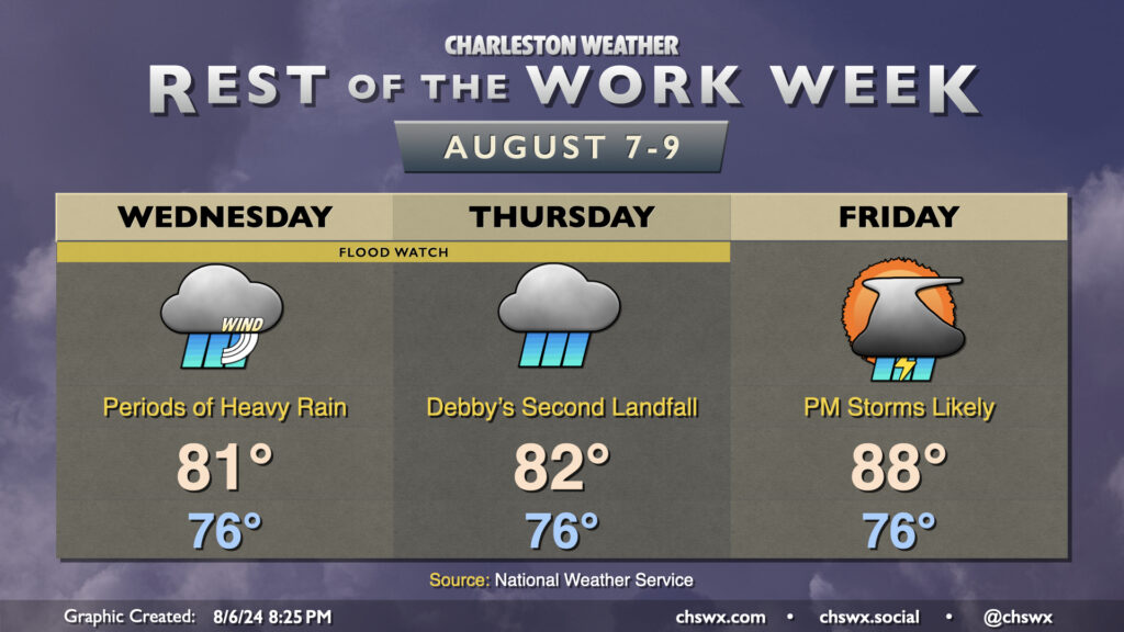
Showers with occasional downpours and some gusty winds to around 35 MPH have been commonplace throughout Wednesday and that should continue into the overnight through Thursday. Another inch-plus of rain should fall overnight through Thursday morning in the metro proper, with upwards of 2″ possible further inland (generally north and west of 17-A) where a fairly persistent rain band has been parked for a fair bit of the day.
We should see generally improving conditions on Thursday. Some spots may get another half-inch of rain or so as Debby begins to depart the area, and it’ll still be a little breezy, but overall, Debby’s effects will be winding down. Expect temperatures on Thursday to run a little warmer than they have in previous days, heading into the mid-to-upper 80s in the afternoon as the cloud shield begins to thin out.
Tropical Storm Debby will continue to figure prominently in the forecast as we head through the middle of the week with continued periods of heavy rain and gusty winds before a more standard summertime pattern once again starts to take hold Friday.
Debby made landfall this morning along the Big Bend of Florida as a Category 1 hurricane. It’s since fallen back to being a tropical storm with max winds now at 50 MPH, but its forward speed has been slowing as steering currents collapse around it. This is setting the stage for the well-advertised prolonged deluge and flash flood threat that will unfold particularly over the next couple days.
The weather story this week is Tropical Storm Debby. Some rain associated with the system has already tried to push ashore Sunday evening, and there’s a lot more where that comes from as we get into the first few days of the new work week. The forecast continues to call for Debby to stall out and meander over Georgia, causing excessive rainfall that could lead to widespread significant flooding across the Lowcountry over the next several days. We will also deal with the potential for tropical storm-force winds, storm surge, and tornadoes as well. The slow-moving nature of the storm increases the uncertainty about exact numbers for impacts as well as on timing, but we’ll do our best here within the limits of the science.
Tropical Storm Debby, newly christened as of 5PM, will march up the Florida coast on Sunday, strengthening as it goes over 90°+ degree water in the Gulf of Mexico. Here at home, moisture will begin to increase ahead of the storm, and that should lead to scattered to numerous showers and thunderstorms in the afternoon and evening hours. Expect balmy lows in the upper 70s to yield to highs in the upper 80s in the afternoon as the flow begins to turn more onshore and showers and thunderstorms become more numerous. A strong storm or two can’t be ruled out, as is normally the case this time of year.
So the disclaimer at the outset with this weekend’s forecast, especially for Sunday, is that a lot hinges on the eventual path, forward speed, and strength of what is, as of this writing, Potential Tropical Cyclone Four. You’ll want to keep closer tabs on forecast updates than you normally might as things are a little more fluid than normal due to the uncertainty.
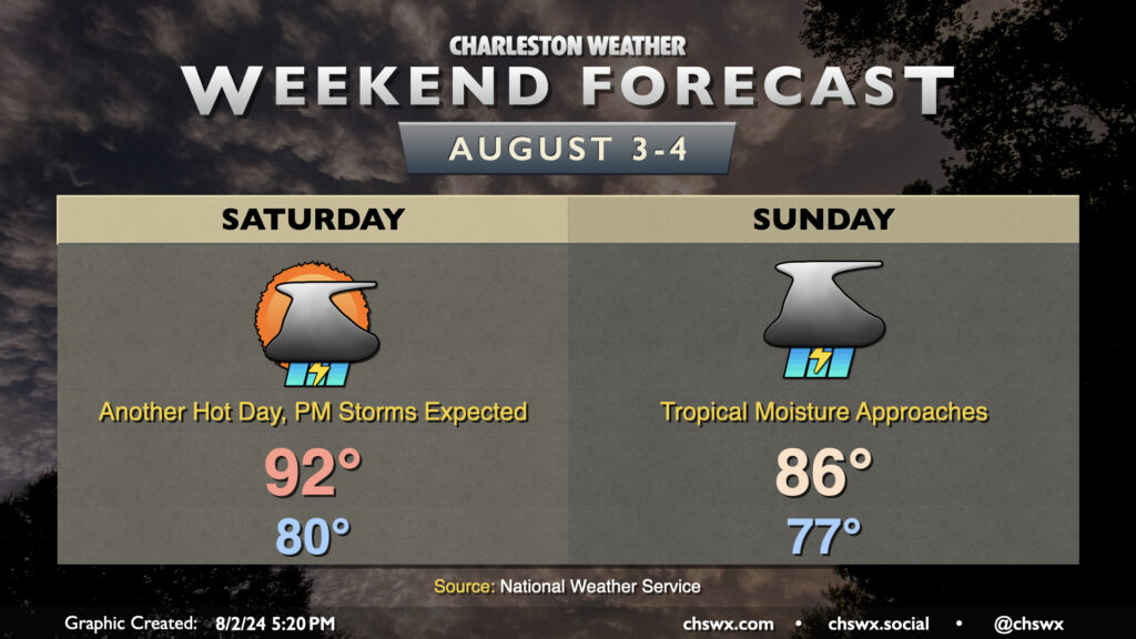
With that in mind, though, one thing that’s certain is that Saturday is going to be a hot and muggy day with ample storms in the afternoon. Temperatures don’t look to get below 80° across more of the metro area than we might like, warming to the low 90s in the afternoon. Dewpoints in the upper 70s will yield heat indices that peak around advisory criteria (108°) before showers and storms develop and cool things down.
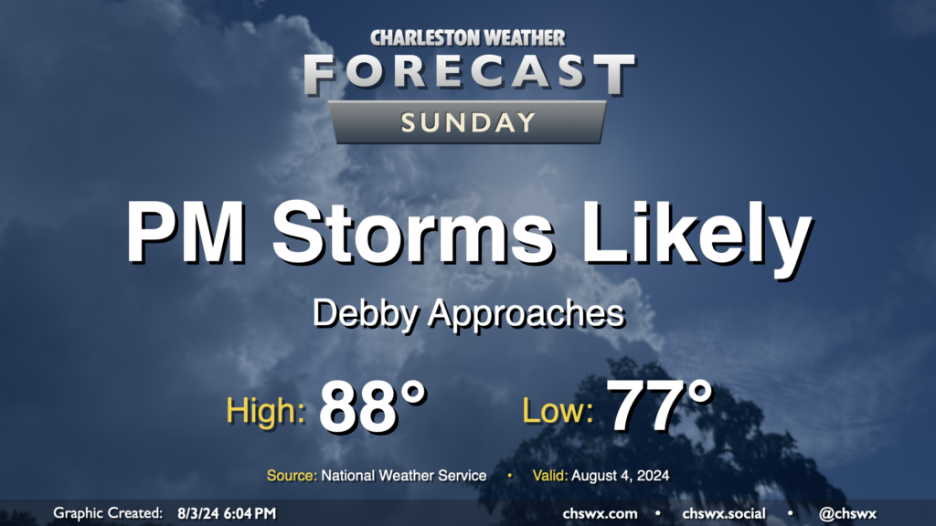
Sunday will start on the mild side once again, but showers and thunderstorms should — provided the current NHC track for Four holds — become fairly widespread across the area by Sunday afternoon as the surge of tropical moisture and a little daytime heating combine for some rather heavy downpours. The upside will be that highs will be suppressed to the mid-80s, but I’d expect it to be soggy enough to where we wouldn’t get to enjoy that all that much. An inch or two of rain will be possible Sunday, especially near the coast.
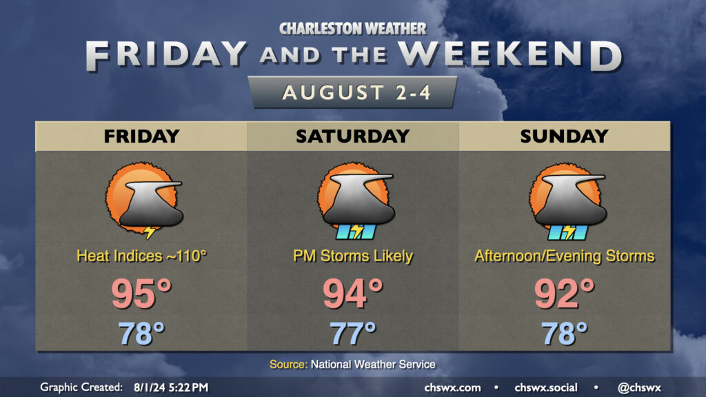
The weather stays hot and turns increasingly unsettled as we get into Friday and the weekend. Warmth peaks Friday; expect highs in the mid-90s to combine with dewpoints in the mid-to-upper 70s to yield heat indices approaching 110°. Another Heat Advisory, while having not yet been issued at publish time, certainly seems like a decent possibility for Friday, so keep that in mind if you have outdoor activities planned. Scattered showers and thunderstorms should provide some relief to a few of us, though slow-moving storms are certainly a possibility and could lead to some localized flooding. Strong wind gusts remain a concern as well.
Shower and storm chances increase heading into Saturday and especially on Sunday as a weakening front approaches the area and stalls out. Temperatures will start to trend downward a bit thanks to the increase in storm coverage and cloud cover, though Saturday continues to look quite toasty with peak heat indices around 105°. Storms should fire by mid-afternoon and could be somewhat numerous Saturday. Greater coverage is expected on Sunday as the front stalls nearby and moisture continues to increase. That’ll keep highs in the low 90s at most in the afternoon. While it won’t rain all day at any one location, slow-moving storms could produce localized flooding. Be ready to halt outdoor activities if a storm approaches.
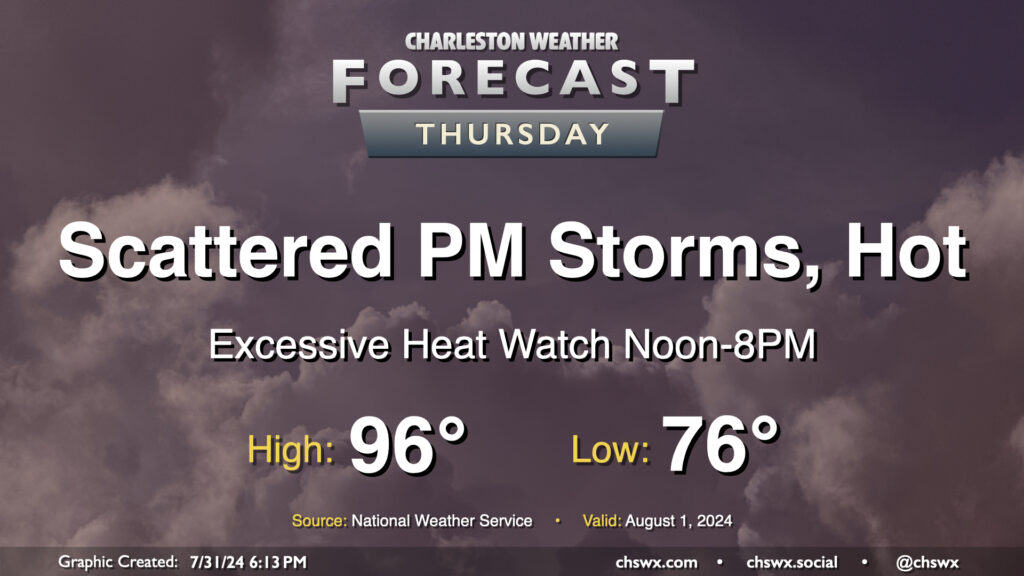
Heat will be the main weather story on Thursday as air temperatures reach into the mid-90s and dewpoints peak in the mid-70s, combining for heat indices that could approach 110-115° in the afternoon. This has prompted an Excessive Heat Watch from noon-8PM, when heat indices could be highest. If the forecast indicates heat indices approaching or exceeding 113°, this could be upgraded to an Excessive Heat Warning; otherwise, a Heat Advisory would likely be the move barring an unexpected cooler start (like we saw today, in fact!)
Showers and thunderstorms will be possible in the afternoon and evening hours as the seabreeze pushes inland. We could also see storms coming our way from the Midlands once again as well. Widespread severe weather is not expected, but you can never rule out a damaging wind gust or two this time of year.