Jared Smith founded @chswx on Twitter in 2008 as an experiment in disseminating weather data through social media. In the ensuing decade-and-a-half, @chswx has provided live coverage of tropical cyclones, tornadoes, severe weather, and even a couple bouts of winter weather to the good people of Charleston, SC.
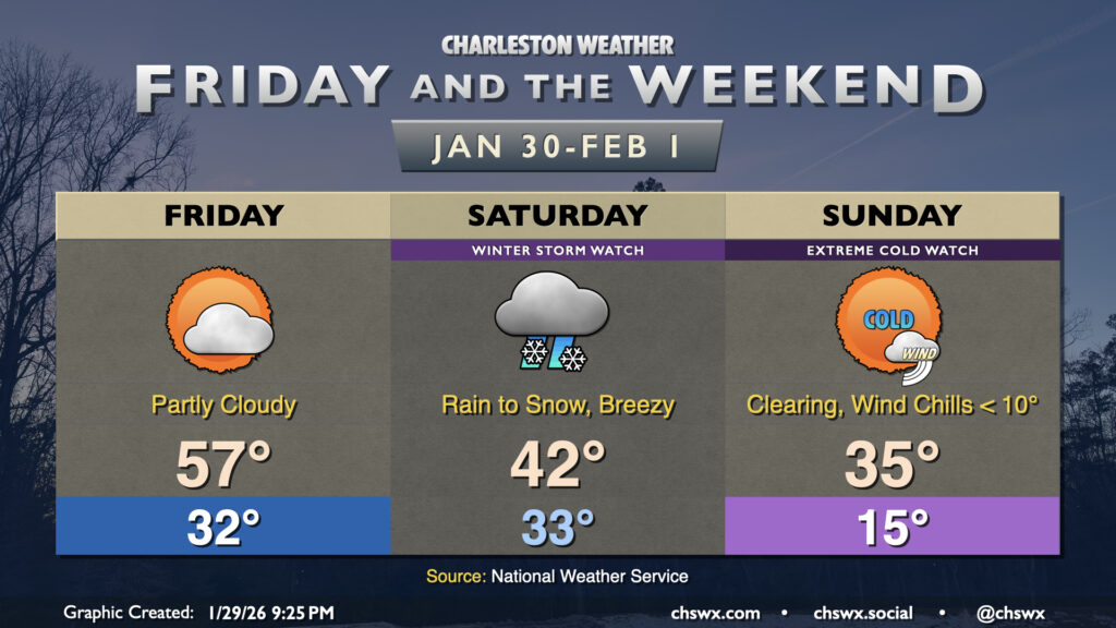
A cold and snowy weekend lies ahead as the storm we in the weather enterprise have been watching closely for the last several days in guidance looks to become a reality for a pretty solid winter weather event for this neck of the woods on Saturday followed by bitterly cold temperatures on Sunday. A Winter Storm Watch and Extreme Cold Watch have been issued by the National Weather Service for much of the weekend, so that’s how you know it’s getting real.
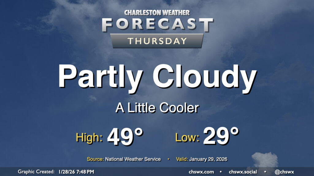
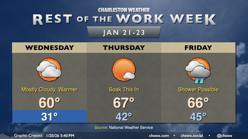
Another chilly day lies ahead for Thursday as a dry cold front slides southward across the area, reinforcing the cooler airmass that’s been in place for much of this past week so far. Temperatures will start in the upper 20s to around 30° for yet another subfreezing start this week. We’ll see some clouds at times, with greater cloud cover expected as we get into the evening, but otherwise there should be plenty of sunshine. Despite the sun, though, the reinforcing shot of cooler air keeps highs pinned to the upper 40s to around 50°.
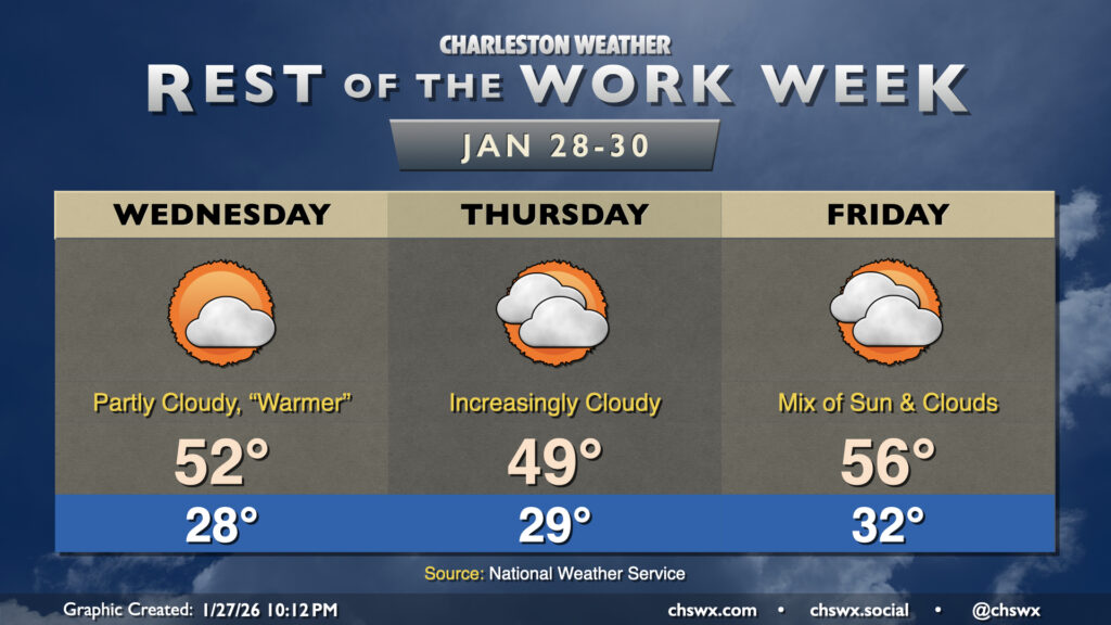
While it won’t be quite as chilly as Tuesday was, the rest of the week will continue to feature below-normal temperatures as Arctic air continues its residence across the area. Wednesday starts in the upper 20s, warming to the low 50s in the afternoon under a mix of sun and clouds. A dry front will sag south across the area Thursday, which will cool things off and cloud up the skies a little bit. Temperatures Thursday once again start in the upper 20s, warming to the upper 40s to about 50° in the afternoon. The cloud cover insulates us a bit overnight Thursday into Friday, with lows only dropping to the low 30s (and staying above freezing toward the coast). Highs Friday warm to the mid-50s as more onshore flow takes over.
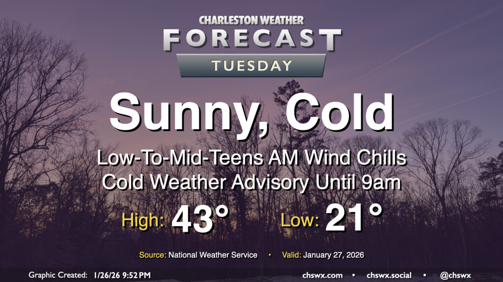
Tuesday will get off to a very cold start across the area as Arctic air continues to spill in, sending air temperatures to the low 20s and maybe even some upper teens further inland. Northerly winds around 5-10 MPH will make it feel closer to the low-to-mid-teens in the morning, prompting a Cold Weather Advisory that will run until 9am. Bundle up carefully and with plenty of layers for heading out to work or school as this is bitter cold for this part of the world. With cold air continuing to blow in, highs on Tuesday only peak in the low-to-mid-40s despite plenty of sunshine. This is well below normal for late January — climatological average high temperatures are around 61° at this point in the still-young year. Stay warm!
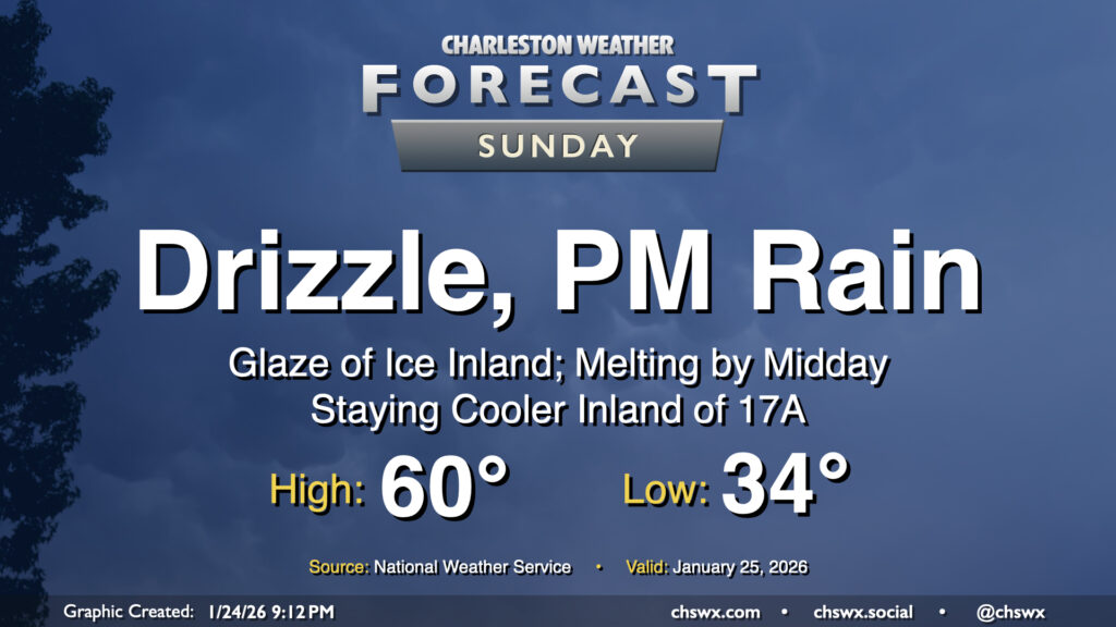
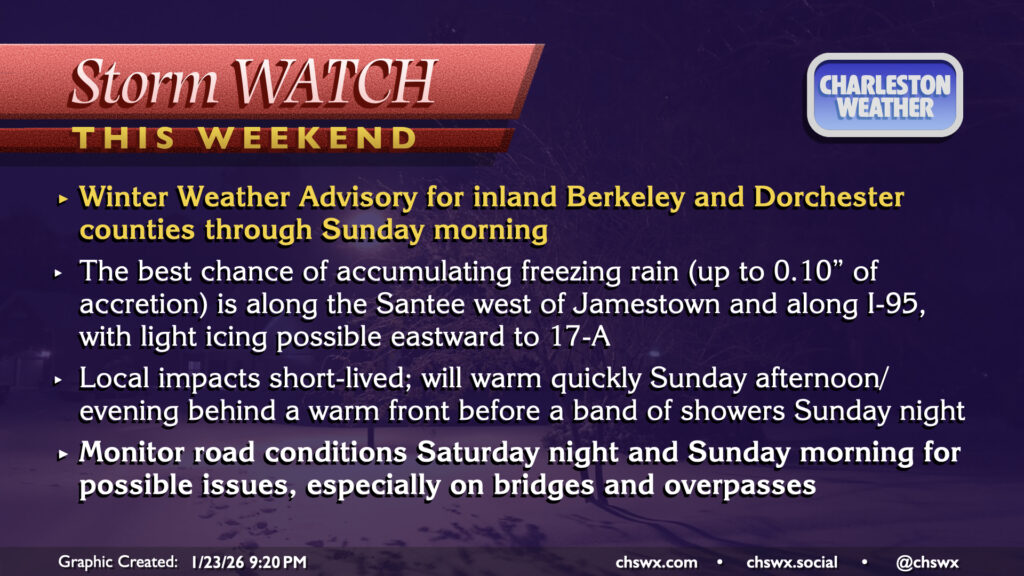
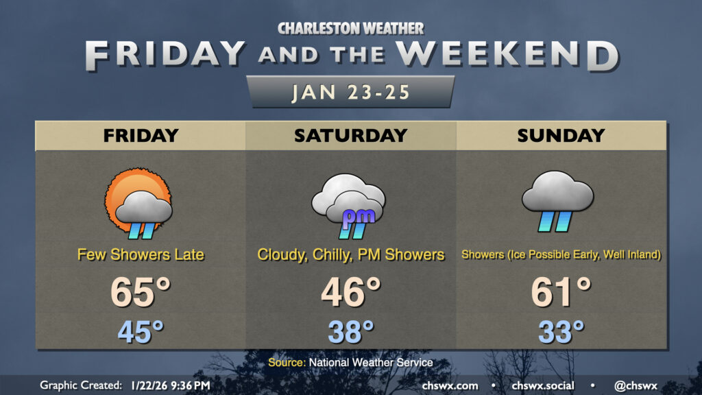
Cooler air will continue to overspread the area tonight, and warm air overrunning the shallow layer of cold air could help to generate some freezing rain or drizzle generally inland of 17-A overnight into tomorrow morning. Folks in inland Berkeley and Dorchester counties remain under a Winter Weather Advisory until 1PM Sunday for this threat. The main concerns will be a glaze of ice on elevated surfaces, perhaps including bridges and overpasses. It continues to appear that we should stay liquid in Charleston County, especially near the coast, so no Ravalanche redux is expected this go-around. As NWS put it in a briefing call this evening, this is a nuisance event rather than a more impactful event.
Any ice that does form will melt during the day as we should see temperatures creep above freezing across much of the area. A more pronounced warming is likely to take place as a warm front lifts northward across the area later Sunday, though it remains to be seen just how far north the warm front can erode the strong wedge of high pressure that’ll be in place. It’s possible that some of us further inland could be stuck in the 30s while we warm to near 60° near the coast in the afternoon and evening. From there. a band of showers and perhaps even a few thunderstorms will sweep through the area later Sunday evening into early Monday morning. Then, a cold front sweeps through the area by daybreak Monday, and sets the stage for a very cold final week of January.
A reasonably busy weekend of weather awaits in the Lowcountry as we deal with the south side of a massive and likely potent winter storm, the effects of which are starting to develop across Texas into the Midwest before spreading eastward during the day tomorrow into the Mid-South and eventually to the Eastern Seaboard.
For our part, a Winter Weather Advisory has been hoisted for inland Berkeley and Dorchester counties, with some freezing rain expected between Saturday night and Sunday morning. Elsewhere in the Charleston Tri-County area, we’ll deal with periods of cold rain as well as some windy conditions. Comparatively, though, this will be this storm on easy mode for a lot of us — some really treacherous conditions are likely to develop across the northern half of the state into NC. Read on to learn what’s most likely to happen in your neck of the woods.
After a high of 72° on Thursday, we’ll turn progressively cooler heading into the weekend as a large storm system affects much of the southern and Mid-Atlantic states over the next few days. Fortunately, the risk for accumulating ice continues to decrease into oblivion for much of the Charleston metro area.
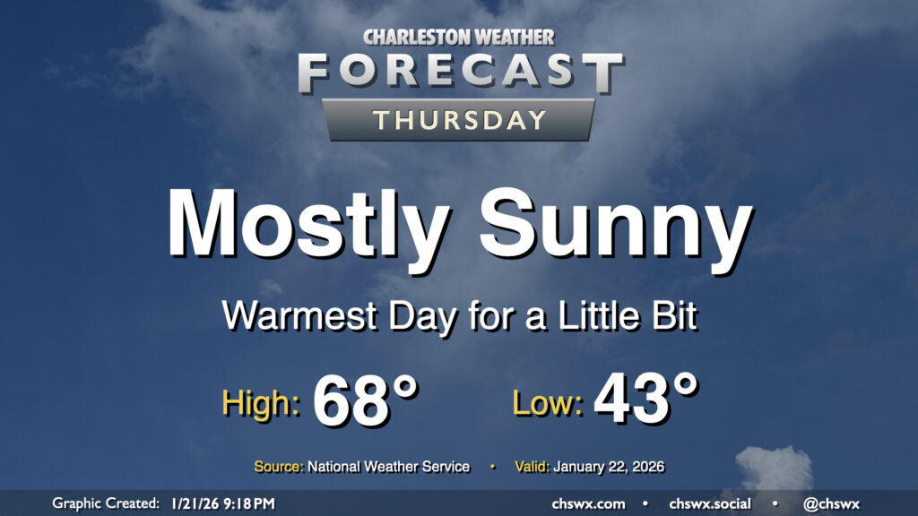
Thursday looks like the nicest day we’ll have for a little while before the well-advertised winter storm system impacts the South, followed by a round of Arctic air to kick off next week. Temperatures Wednesday start in the low to mid-40s — a marked increase from the low of 26° at the airport this morning — before warming to the upper 60s to perhaps even around 70° under mostly sunny skies. Enjoy this — as mentioned, things will start getting stormy and chilly by Saturday.
Temperatures will warm up for the second half of the week ahead of what is shaping up to be a rather messy weekend, with the risk for winter weather increasing especially away from the coast.