Jared Smith founded @chswx on Twitter in 2008 as an experiment in disseminating weather data through social media. In the ensuing decade-and-a-half, @chswx has provided live coverage of tropical cyclones, tornadoes, severe weather, and even a couple bouts of winter weather to the good people of Charleston, SC.
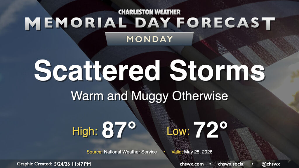
A few more showers and thunderstorms will be possible on Memorial Day, but overall it will be a fairly decent representation of summertime. We’ll start the day in the low 70s, warming to the mid-to-upper 80s in the afternoon. Showers and thunderstorms will be most likely in the morning, propagating inland during the day. Coverage will be less than Sunday, but you’ll still want to keep an ear out for thunder, which will be your signal to head indoors as at that point, you are at risk of getting struck by lightning. However, this is no reason to cancel any outdoor plans — just make sure you’ve got a good secondary, indoor plan.
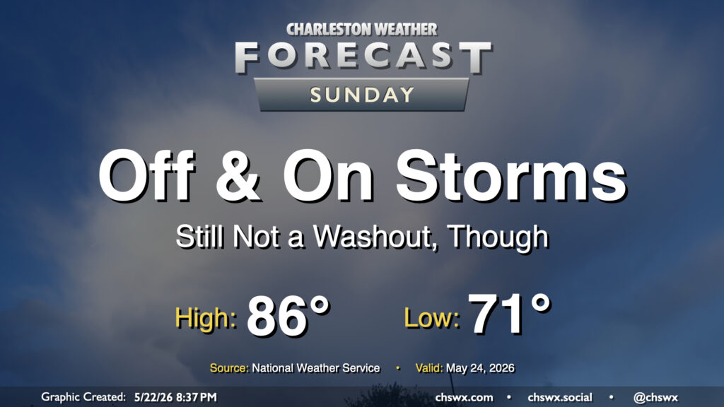
Showers and maybe a few thunderstorms will continue to be in play for the forecast as we get into the midpoint of the long Memorial Day weekend, though the greater activity will continue to be found along and west of the I-95 corridor. For Sunday, we can expect the bulk of our activity likely during the morning and early afternoon hours before the seabreeze pushes inland and takes most of the activity with it. However, showers will be possible throughout the day, so be ready to move outdoor plans inside just in case a shower or thunderstorm approaches.
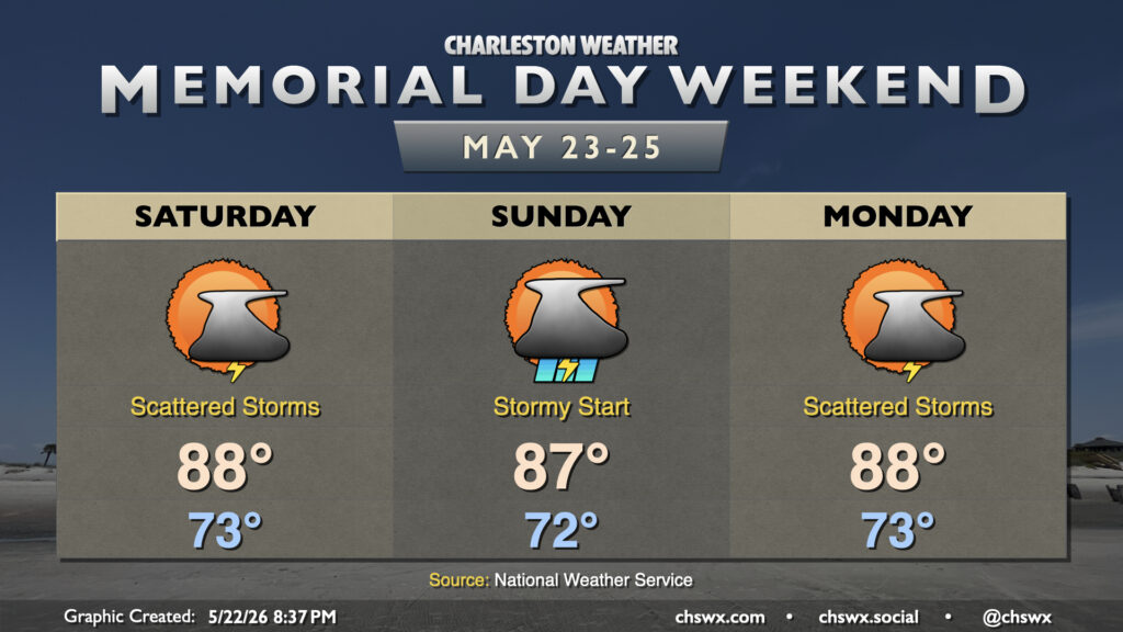
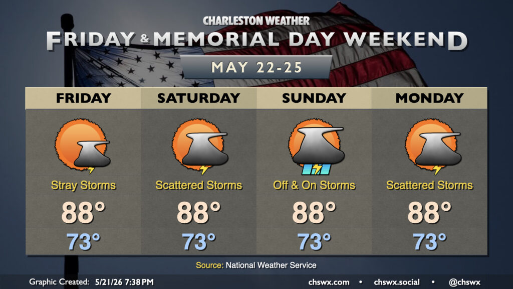
Shower and thunderstorm chances will accompany a warm and muggy Memorial Day weekend, but don’t expect a rainout, either. Temperatures will generally run in the upper 80s each day, but dewpoints around 70° will make it feel closer to 90-91° pretty much every afternoon.
It’s a very summer-like look to the forecast this Memorial Day Weekend as the Lowcountry sits on the fringes of Atlantic high pressure. The pattern is largely stagnant as evidenced by the copy & paste temperatures for the next few days: lows in the low to mid-70s, highs in the upper 80s to near 90°.
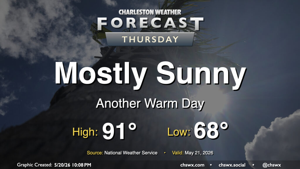
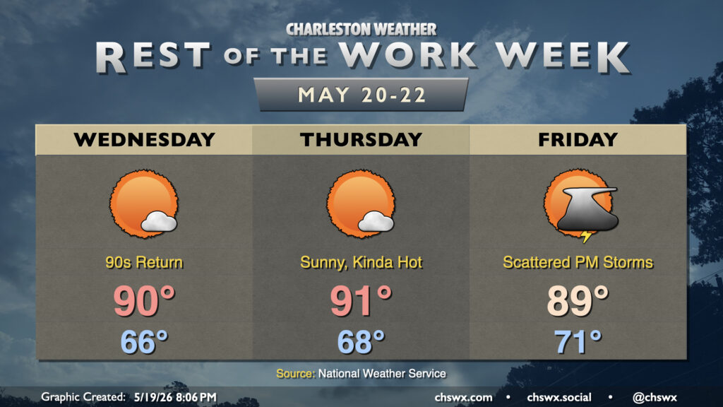
After another day in the upper 80s on Wednesday — just missing 90° by a couple degrees at the airport — we should turn even a little warmer for Thursday with plenty of sunshine to be had. It’ll be a bit of a balmy day in general as lows in the upper 60s warm to the low 90s in the afternoon. Mid-60s dewpoints will keep the heat index in check, though it may feel a tick or two warmer than the air temperature.
High pressure at the surface and aloft along with plenty of sunshine will help bring the 90s back to the Lowcountry over the next few days for the first time since mid-April. Dewpoints will not quite head back to those summertime 70s just yet, thankfully, so heat indices will remain in check, but it’ll still be plenty warm and a harbinger of things to come as we head toward June.
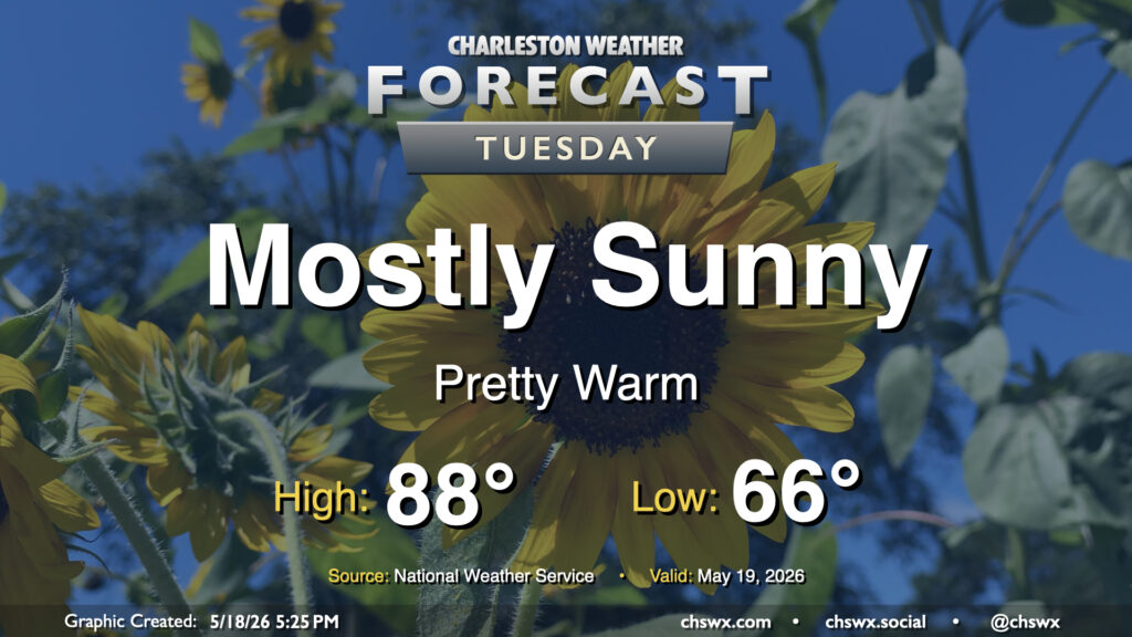
More sunshine is in the offing for Tuesday with high pressure in continued control of our weather. The air will have a bit of an early summer feel to it with lows bottoming out in the mid-60s, warming to the upper 80s and perhaps approaching 90° in the afternoon. Dewpoints will mix down to the mid-60s in the afternoon, so while it won’t be excruciatingly humid, there will definitely be a bit more heaviness to the air, so to speak.
The upcoming week will have an early-summer feel with high pressure remaining in control for the first part of the week before a front stalls out nearby, bringing some rain chances back into the picture heading into the weekend.
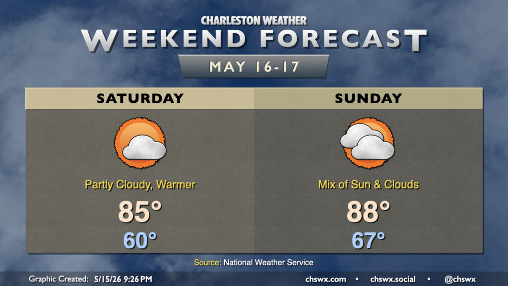
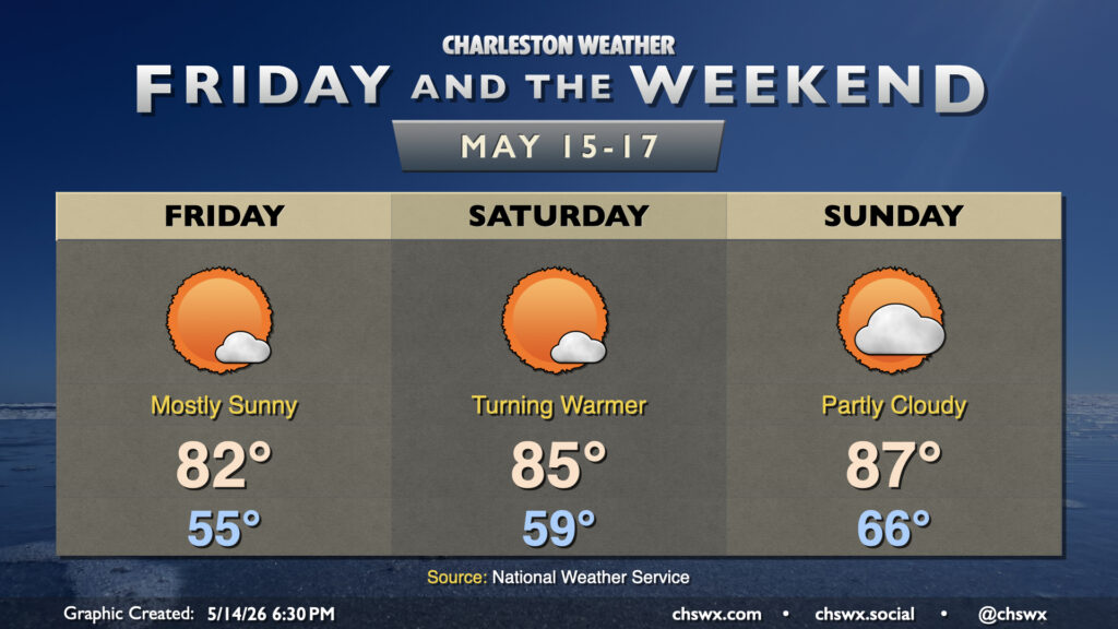
We’ll turn warmer over the weekend as high pressure aloft and at the surface remain the main weather features. With high pressure moving offshore, winds out of the south and southeast will bring warmer and somewhat more humid air into the area. This will contribute to a little more in the way of cloud cover, but despite that cloud cover, highs still peak in the mid-80s. Clouds thicken in the mid and upper levels on Sunday, but that doesn’t stop temperatures from running in the upper 80s in the afternoon. Shouldn’t see any rainfall, though, as the better moisture and rain chances will be well, well inland. Not excellent for the ongoing extreme to exceptional drought across parts the Lowcountry.
Generally quiet weather will continue for Friday and the weekend with high pressure in control. If you liked Thursday’s weather, we have more of that comfortable warmth in store for Friday. We’ll start the day a bit below normal — generally mid-50s — and warm to the low 80s in the afternoon.