Jared Smith founded @chswx on Twitter in 2008 as an experiment in disseminating weather data through social media. In the ensuing decade-and-a-half, @chswx has provided live coverage of tropical cyclones, tornadoes, severe weather, and even a couple bouts of winter weather to the good people of Charleston, SC.
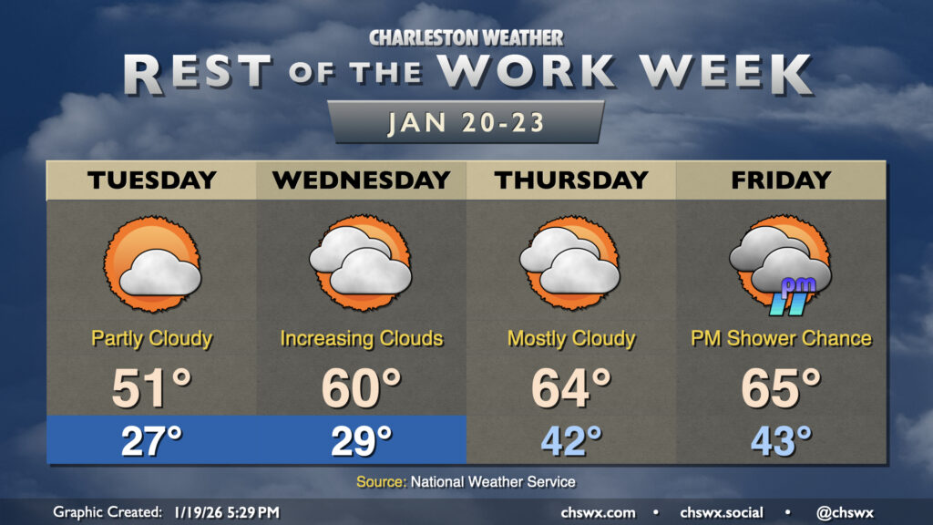
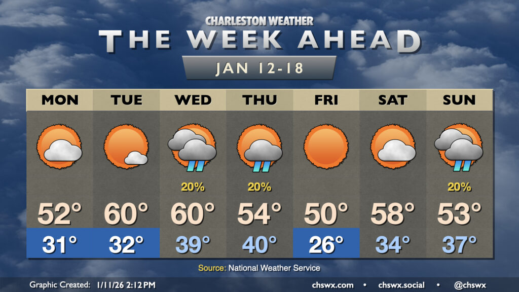
Chilly mornings will continue through Wednesday as another reinforcing shot of cool air moves in overnight Monday into Tuesday. We’ll start Tuesday back in the mid-to-upper 20s, but northwesterly winds around 5 MPH or so could make it feel closer to 20°, so be sure to layer appropriately heading out to work or school. Temperatures will only make it to the low 50s as the influx of cool air continues throughout the day. Expect a scattering of clouds, but still plenty of sunshine.
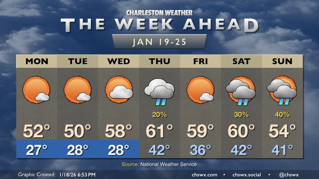
After some much-needed rain on Sunday, we get into a stretch of a few quiet but chilly days beginning on Monday. We’ll start Martin Luther King, Jr. Day in the mid-to-upper 20s across much of the metro away from the immediate coastline. There’s a slight chance for a little black ice in more sheltered and rural areas in the morning, but the vast majority of us will be okay as drier air with elevated winds should evaporate much, if not all, of today’s rain before things freeze. Temperatures will head into the low 50s with plenty of sunshine.
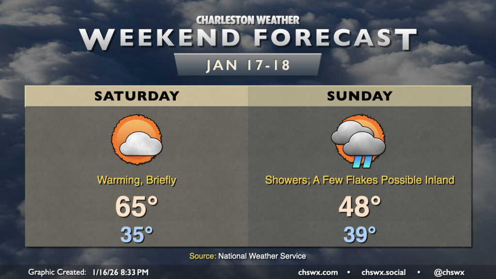
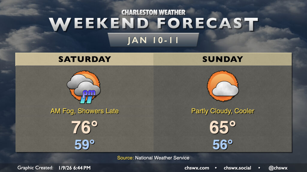
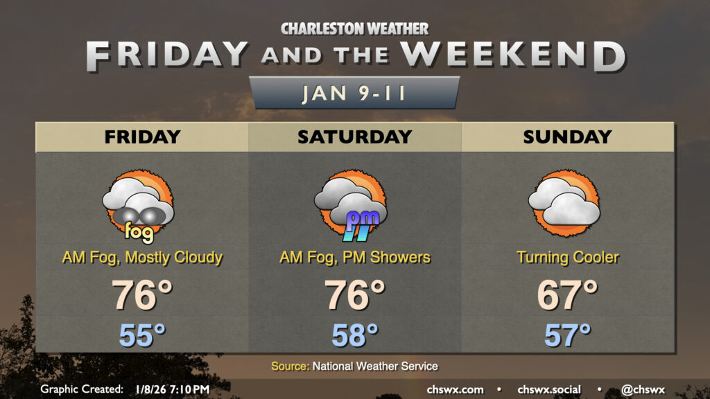
Topsy-turvy temperatures will feature prominently this weekend as a decently strong cold front comes through on Sunday. Ahead of that front, Saturday temperatures will warm from the mid-30s in the morning to the mid-60s in the afternoon as warmer air pumps in from the south and southwest. We’ll see clouds on the increase as the day goes on with the approaching front and a strong trough of low pressure that’ll help drive that front through and bring some much-needed rain for Sunday.
A lot has been made of the risk for winter weather on Sunday, but the ultimate outcome looks to be mostly rain for the Charleston metro area, with some flakes likely mixing in the further west toward I-95 you go. The front itself gets through early in the day, with the precipitation developing behind it as the trough of low pressure swings through. While it will stay mostly rain near the coast, a few flakes could mix in along and west of 17-A. However, accumulating snow, if snow falls at all, is not expected given surface temperatures in the upper 30s to mid-40s. Travel issues beyond the elevated risk of distracted driving at the sight of novelty snowflakes are not expected.
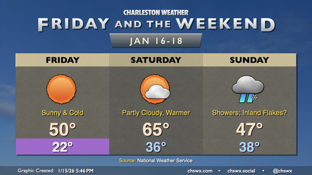
A very cold night is on tap tonight as high pressure settles in across the area, bringing winds down but also helping to create ideal radiational cooling conditions that will send lows to the low 20s across much of the metro by Friday morning, with 20s even reaching the beaches. Further inland, we could see temperatures dip into the upper teens. A Cold Weather Advisory is in effect for Berkeley and Dorchester counties where the most chilly conditions are expected. This’ll be pipe-busting cold so make sure you’ve got a faucet dripping, plants are covered, pets are inside and warm, and the vulnerable people in your life are accounted for and safe.
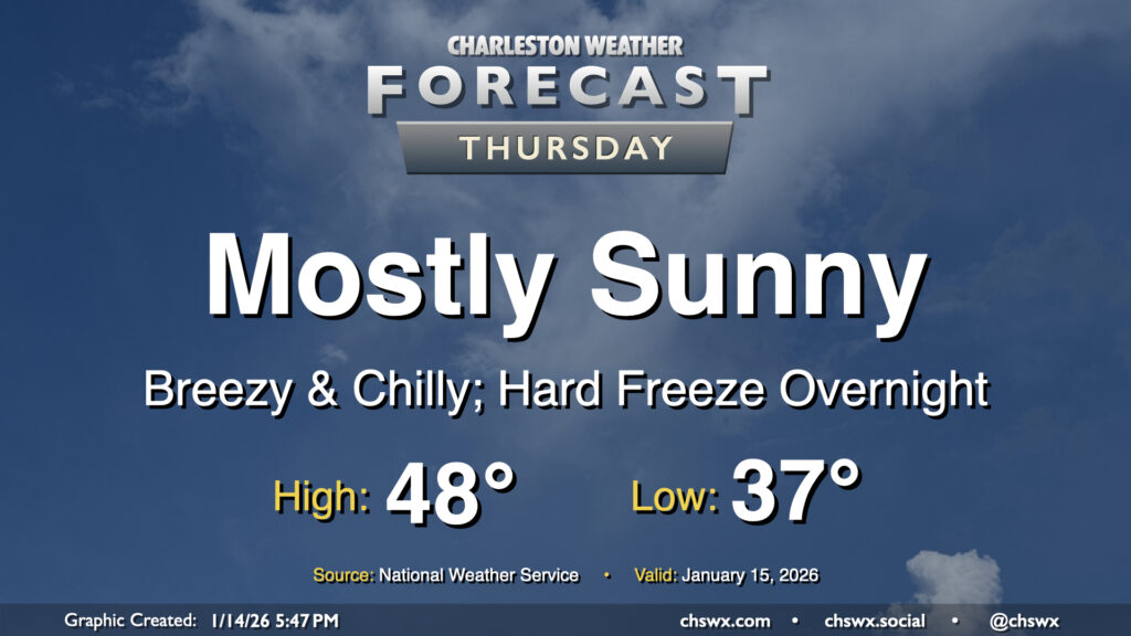
A cold front will come through early Thursday, ushering in another round of very cold and dry air to the area which may elevate fire danger during the day. We’ll start the day in the mid-to-upper 30s with a few clouds around. Those clouds will largely scour out as the drier air punches in, and it will punch in — expect winds around 10-15 MPH with higher gusts at times. The influx of cold air will limit highs to the upper 40s despite full sunshine, and with the wind, it’ll feel even cooler than that. This will lead to a hard freeze overnight Thursday into Friday morning, so you’ll want to make sure that pets, plants, pipes, and people are protected as temperatures plummet into the low 20s by Friday morning.
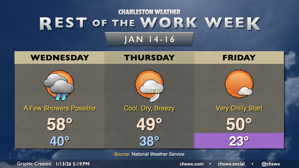
Another big cooldown is in store as we get beyond Hump Day and head into the second half of the work week. First, though, we’ll have a relatively seasonally-appropriate Wednesday, with highs topping out in the upper 50s to around 60° after a low around 40°. There will be a bit more in the way of cloud cover, with a chance for a few showers in the afternoon as low pressure moves northward out of the Bahamas, spreading a little moisture our way. Don’t expect much in the way of any meaningful rainfall, though, if you see any at all.
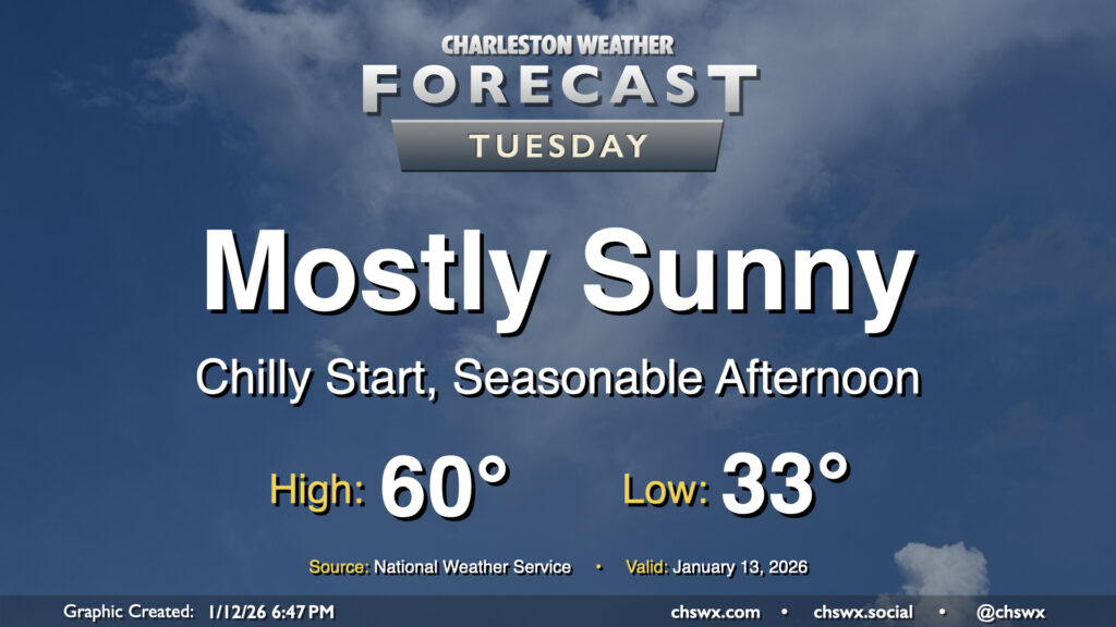
We’ll get off to another rather chilly start on Tuesday, with sheltered and rural locations headed below freezing and the metro getting awfully close (if not tipping below 32°F, too). At least the wind won’t be a factor — maybe a very light breeze, but that’s about it. Temperatures will then warm to around 60° in the afternoon, which if realized would be right on the nose for what climatology considers “normal” for January 13. Expect plenty of sunshine with just a few clouds.
This week will have a much different (and more seasonally-appropriate) feel than last week did as multiple shots of cold air are queued up for our neck of the woods.
After a record high on Friday, we’ve got one more warm day ahead before a cold front begins to make things feel a little more like January for Sunday and especially the start of the new work week.
Another round of fog is expected overnight into Friday morning as abnormally warm temperatures continue across the Lowcountry. Lows will fall into the mid-50s, reaching the dewpoint with relatively calm winds. Once again, be prepared for low visibility and delays due to fog as you commute Friday morning. Like Thursday, the fog should mix out by mid-morning, and from there, temperatures will head to the mid-to-upper 70s. We’ll challenge the record high of 78° set in 2012 with a mix of sun and clouds in the afternoon.