Jared Smith founded @chswx on Twitter in 2008 as an experiment in disseminating weather data through social media. In the ensuing decade-and-a-half, @chswx has provided live coverage of tropical cyclones, tornadoes, severe weather, and even a couple bouts of winter weather to the good people of Charleston, SC.
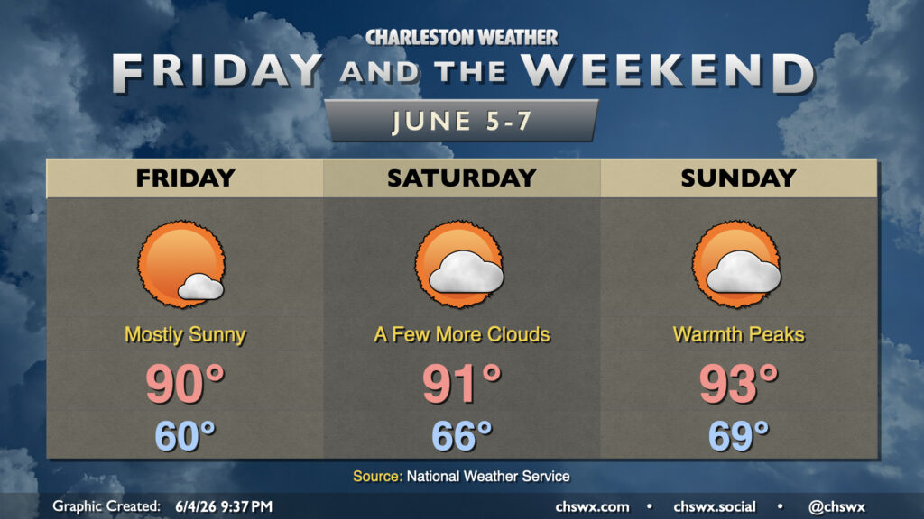
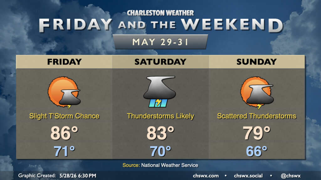
High pressure at the surface and aloft will remain the primary weather driver for Friday and the weekend, with a bit more in the way of heat returning to the area starting Friday. Temperatures Friday start around 60°, warming to around 90° in the afternoon under mostly sunny skies. Dewpoints will remain generally in the 50s before the seabreeze pushes in a little more humid air from the Atlantic later in the day, but even then, they’ll only run in the low 60s with cooling temperatures behind them. It will be one of those rare days where the heat index may actually run slightly cooler than the actual air temperature, in fact, as the relatively dry air will allow sweat to do its thing.
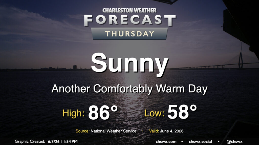
Another comfortably warm day lies ahead for Thursday as high pressure at the surface and aloft remain the dominant weather features. Temperatures will once again start well on the cool side of normal for this time of year, bottoming out in the upper 50s away from the coast. We’ll warm to the mid-80s in the afternoon, but low-50s dewpoints will help not to make it feel terribly uncomfortable.
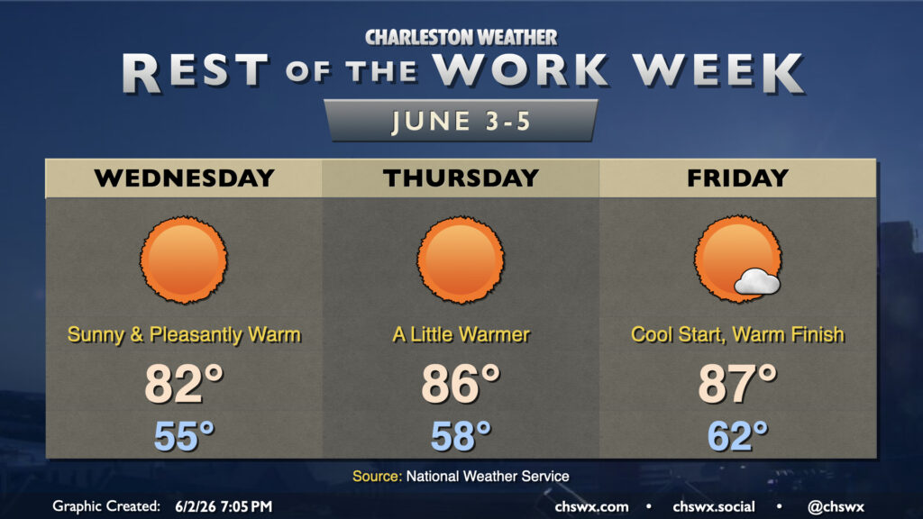
Rain is done for a few days as dry high pressure builds down into the area, bringing about comfortable warmth as we get down the home stretch of the work week. It won’t feel like June on Wednesday as temperatures bottom out into the mid-50s away from the locally warmer coastline. Expect highs to peak in the low 80s in the afternoon with nearly unfettered sunshine as deep dry air sets in. Savor the low humidity because we don’t have too many more days like this left for a while!
If the beach is in your plans, be aware of a high risk of rip currents during the day Wednesday due to the ongoing northeast flow. It’s best to stay out of the water on days like this
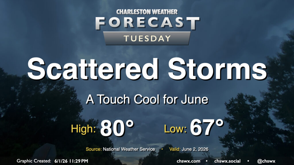
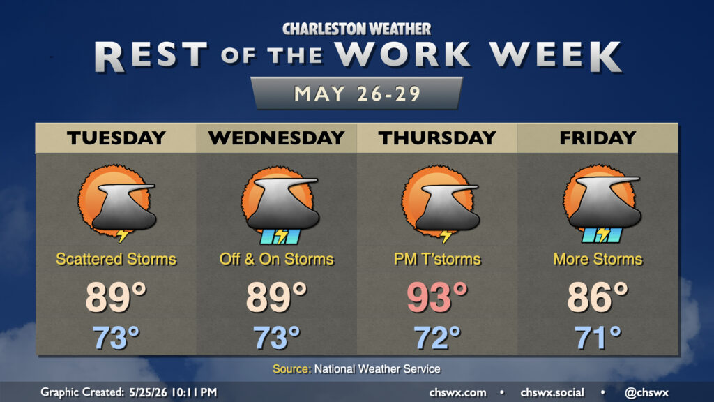
We should see another scattering of showers and thunderstorms on Tuesday in association with a cold front that will make for a rather nice second half of the work week. Temperatures will start in the mid-to-upper 60s, warming to just about 80° in the afternoon as the front pushes further southward and drier air begins to find its way in. Dewpoints should fall nicely late Tuesday into Wednesday, setting up a stretch of spring-like conditions through Friday.
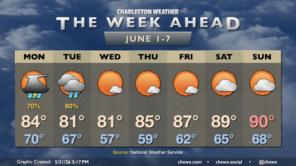
Meteorological summer begins on Monday, but it isn’t going to feel much like it for a few days with unsettled weather to start and cool high pressure for midweek before temperatures rebound toward 90° by the weekend.
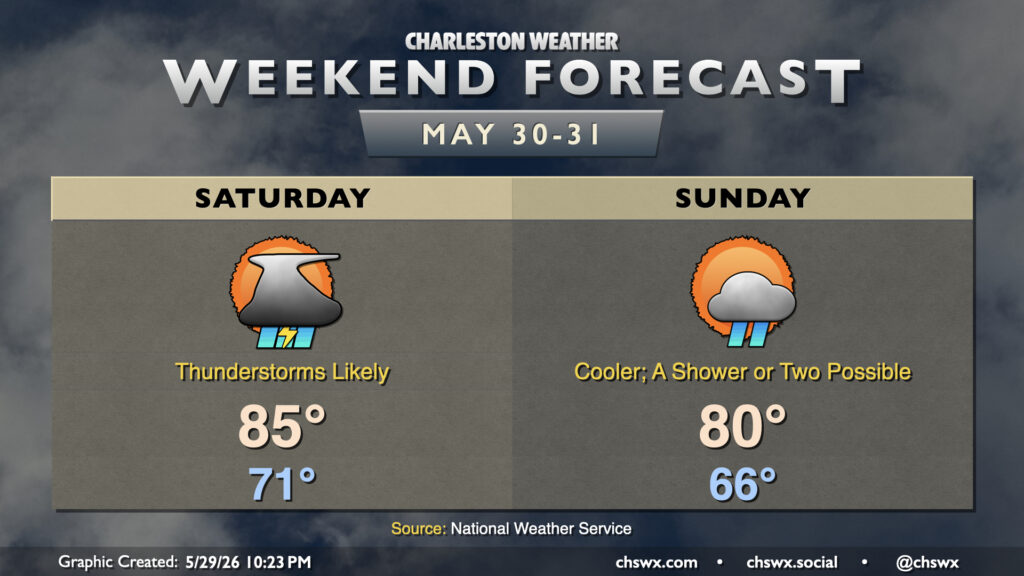
Rain spreads back into the Lowcountry on Saturday as a stationary front buckles back northward across the area. A bit of upper-level energy will also kick in some lift, and that’ll result in scattered to numerous showers and thunderstorms at times on Saturday. Right now it looks like the best chances will be found in the morning through early afternoon hours, but a shower or storm just can’t be ruled out during any part of the day. Temperatures will start in the low 70s, warming to the mid-80s in the afternoon at best.
A cold front pushing southward overnight will stall out to our southwest, pushing some drier air into the area in the meantime and cooling things off a few degrees compared to the past few days. Friday still starts in the low 70s, but still a few degrees cooler than Thursday. Temperatures will head to the mid-80s in the afternoon with a few showers or storms possible midday, but otherwise, expect a quieter weather day compared to Thursday’s rambunctious thunderstorms which brought some much-needed rain to the Highway 17 corridor and points east.
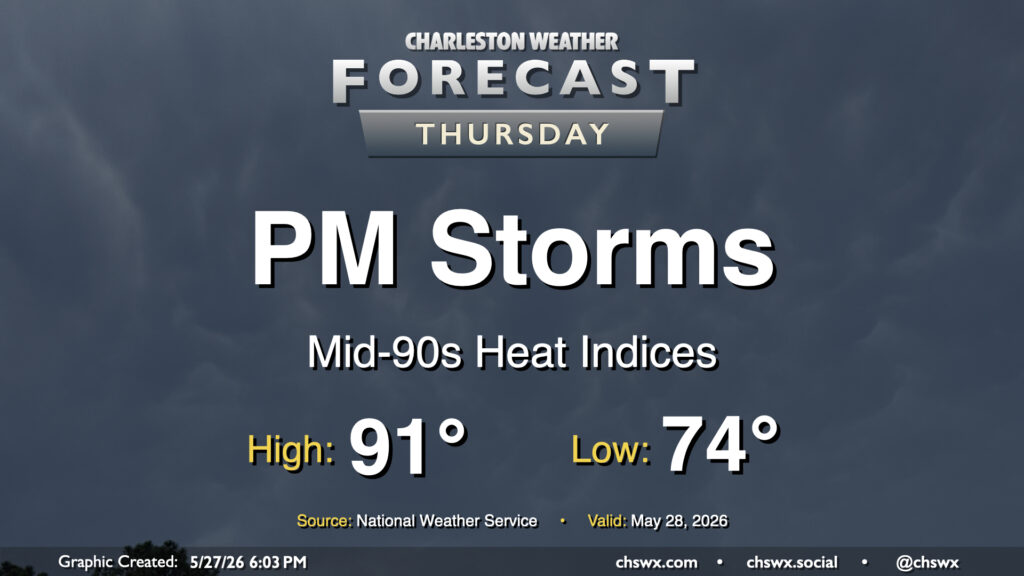
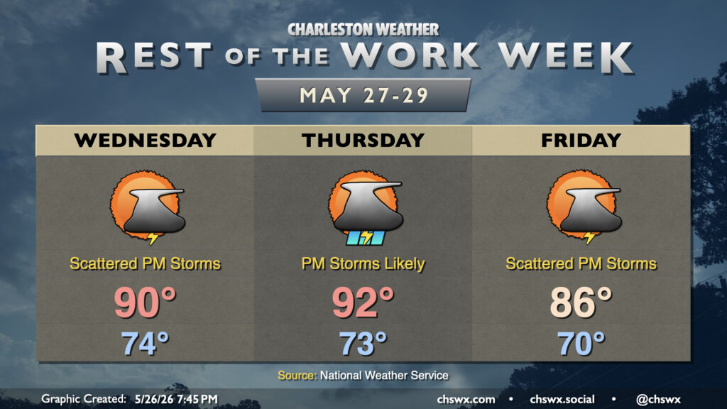
Heat peaks Thursday before scattered to numerous showers and thunderstorms fire along the seabreeze in the afternoon. From there, a cold front sags southward across the area, and keeps shower and storm chances going through Thursday night. We’ll start the day on the warm side with lows in the mid-70s. More westerly winds will keep things a bit drier to start the day, but these winds will help enhance convergence along the seabreeze for those aforementioned showers and thunderstorms as we get into the afternoon. Before thunderstorms begin to disrupt the temperature curve, highs will peak in the low 90s, and heat indices will easily run in the mid-90s, perhaps getting closer to 100° than we’d like in the Highway 17 corridor.
Severe thunderstorms aren’t expected, but some gusty winds can’t be ruled out. There’s plenty of available moisture for a lot of rain to fall in a short period in a few spots, too, but not everyone will see a downpour. However, it seems probable that most of us should be able to measure precipitation by Friday morning.
More opportunities for much-needed rainfall will continue for the rest of the work week and beyond as a front approaches the area and stalls out. Warm and muggy conditions will be a mainstay as well, especially Wednesday and Thursday.
Unsettled weather will continue for the rest of the abbreviated work week as we remain on the periphery of Atlantic high pressure, with plenty of moisture available for the seabreeze and other boundaries to kick off showers and thunderstorms each day. Some much-needed rain will fall, and those chances will improve heading into next weekend.