Jared Smith founded @chswx on Twitter in 2008 as an experiment in disseminating weather data through social media. In the ensuing decade-and-a-half, @chswx has provided live coverage of tropical cyclones, tornadoes, severe weather, and even a couple bouts of winter weather to the good people of Charleston, SC.
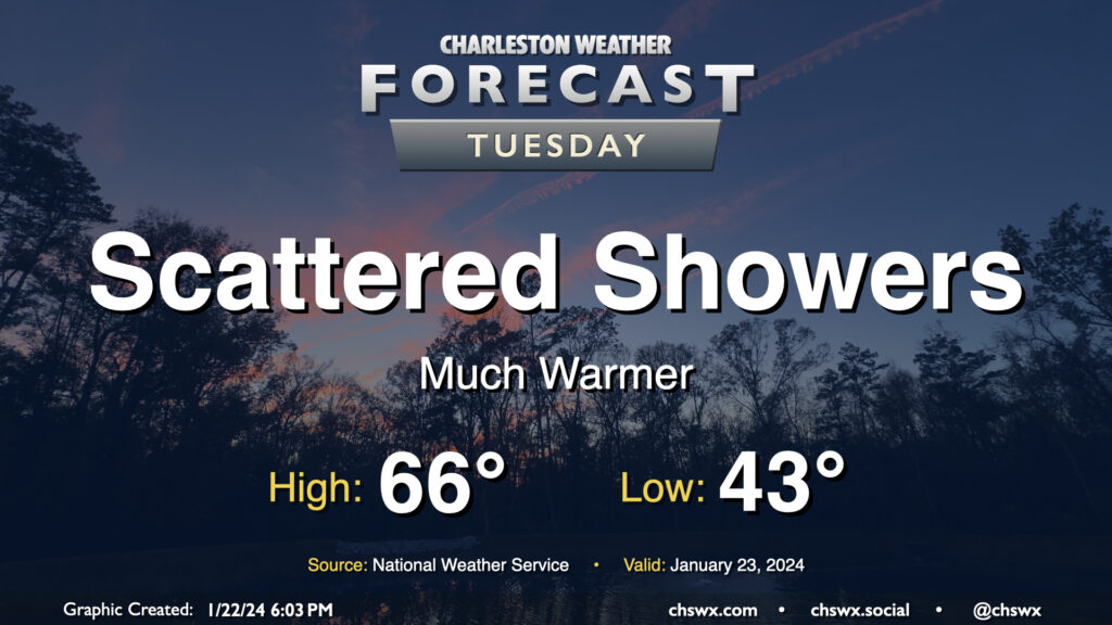
After a day in which we warmed up some 14° compared to Sunday with a high of 60° at the airport, the warming trend continues for Tuesday and beyond as surface high pressure continues to move offshore. Temperatures on Tuesday start in the low-to-mid-40s — roughly where we were for a high on Sunday — and warm into the mid-60s in the afternoon under mostly cloudy skies. A few showers will be possible at times, but any rain will be generally light. Still, y’all know how traffic can get even with the lightest of rain, so prepare accordingly.
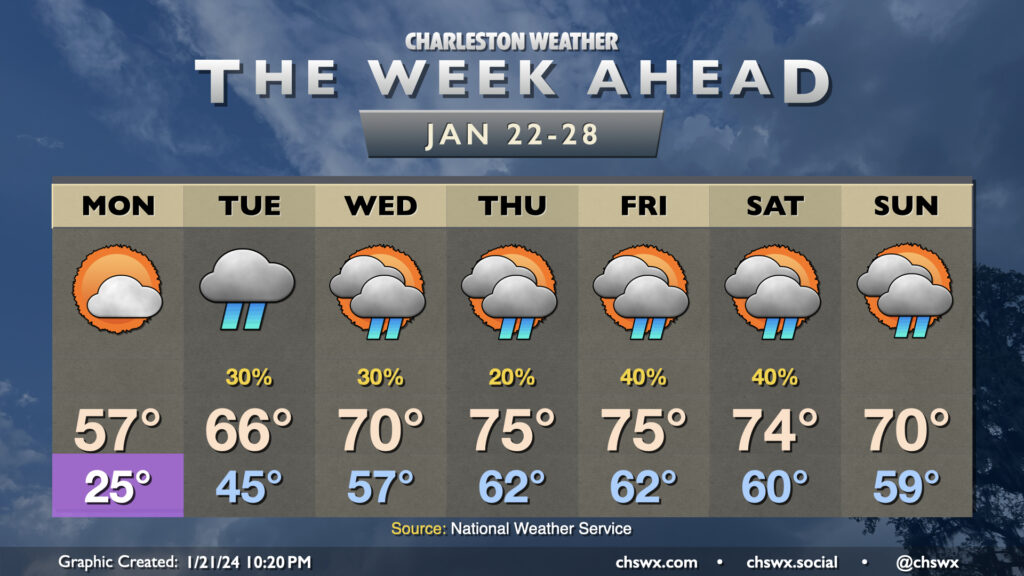
After a quite chilly weekend, we will be thawing out very quickly as we get into the new work week. Monday gets off to one more frigid start with lows in the mid-20s. From there, though, we start to see the arctic airmass begin to modify as a ridge builds aloft and surface high pressure shifts offshore. Monday’s high goes into the mid-50s, much warmer than we were at any point over the weekend. Then it gets downright spring-like: Tuesday warms into the mid-60s after a mid-40s start, and by Wednesday we’re in the 70s. Mid-70s take hold Thursday through Saturday ahead of a cold front, which should help to bring temperatures down a touch by Sunday.
The only fly in the ointment will be scattered shower chances beginning Tuesday and really lasting for the next few days as we sit between an upper trough to the west and ridging to the east. This will transport moisture and occasional upper-level disturbances into the area, and a surface trough along the coast will help act as a focal point for shower development. It won’t rain all the time or all day at any one spot, but all the same you’ll want rain gear handy just in case, especially heading into the weekend as the aforementioned front approaches.
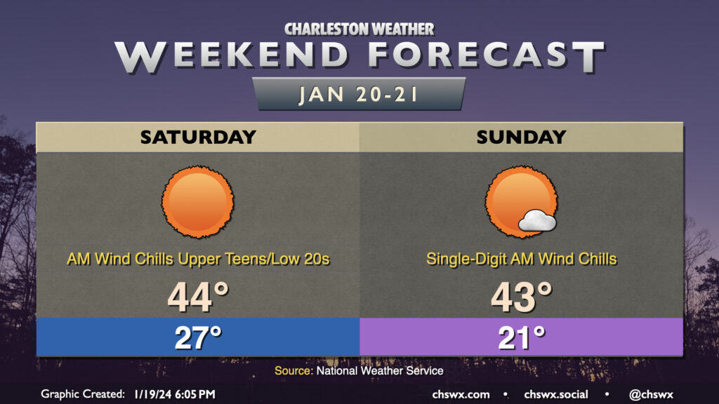
A rather cold weekend lies ahead as Arctic high pressure visits the Lowcountry, especially Saturday night into Sunday, which will require cold weather precautions for the next few nights.
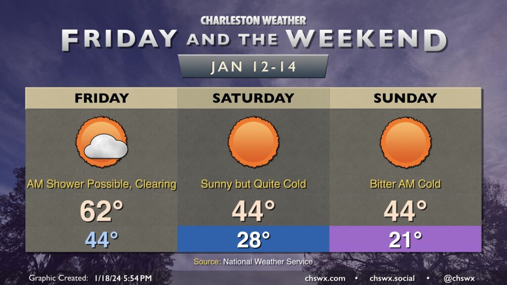
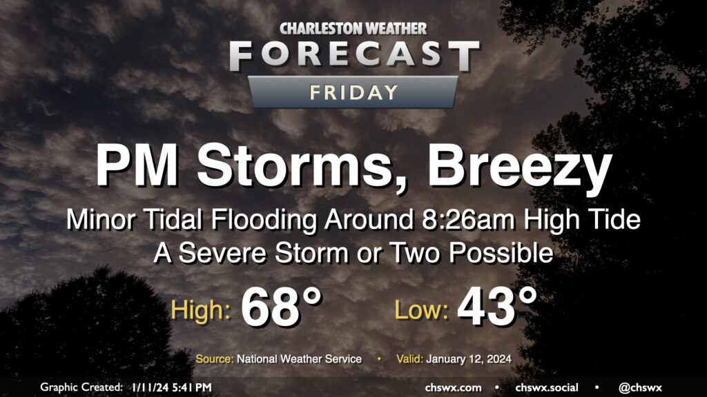
Friday will be the last time for a few days that we’ll start the day above freezing. The day starts in the mid-40s, and there’s a risk for a stray shower or two in the morning. Most will stay rain-free, though. Temperatures will head into the low 60s by early afternoon as a cold front swings through, ushering in drier air that will help scour out the cloud deck. It’ll be windy — gusts 25-30 MPH certainly appear possible as well, so keep that in mind as you commute over bridges.
We’ll start to cool off by late afternoon, and will be quickly into the 40s by 7PM. From there, we will chill out rapidly, and temperatures will fall into the upper 20s by morning. Wind chills will drop to around 20° — and perhaps lower — and could be nasty for morning runs or the like. Temperatures only head to the mid-40s in the afternoon despite full sunshine.
Saturday night into Sunday will feature the coldest temperatures. Lows will fall to the upper teens to low 20s, and wind chills could drop to around 10° or even lower in the morning. A Wind Chill Advisory is probable Sunday morning. Cold weather precautions will be a must: protect plants, pets, pipes, and people. Temperatures on Sunday will head back to the mid-40s in the afternoon, which might feel downright balmy after how the morning will start!
After one more freezing start Monday, though, we warm up — and the 70s look to be back on Wednesday.
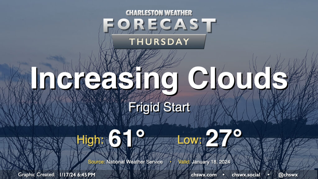
Thursday will get off to a very chilly start across the Lowcountry as calm winds and clear skies combine to allow for a solid radiational freeze across the area tonight into Thursday morning. Expect lows to bottom out in the mid-20s in a fair bit of the metro, with slightly warmer — but still at or very near freezing — temperatures near the coast. Bring pets in tonight and cover sensitive plants. Consider dripping a faucet, too, especially further inland.
The good news is that temperatures won’t stay below freezing for long after the sun comes up. High pressure will move offshore, allowing temperatures to recover to the low 60s by afternoon as cloud cover increases. There is a risk for a few showers very late Thursday into early Friday, but we’ll get the daytime hours in rain-free.
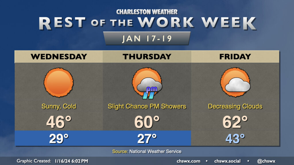
A rather cold day awaits on Wednesday despite full sunshine throughout the day as chilly high pressure builds into the area. Temperatures should fall to the upper 20s in the metro area early Wednesday morning as cold air blows in. Wind chills will bottom out in the low 20s, so be sure to dress accordingly as you head out to work or school. Afternoon highs will struggle to the mid-40s as cold air continues to settle into the area throughout the day. Despite light rain during the day Tuesday, black ice doesn’t look like it will be a factor given that we’ll be drying out very quickly tonight as dewpoints plummet into the 20s.
We’ll dip a little further into the 20s overnight Wednesday into Thursday morning. Temperatures should reach freezing by late evening, and should stay there through sunrise, with roughly an 8-10 hour period of freezing temperatures a decent possibility. It’ll be a good idea to keep a faucet on a drip, make sure pets are in a warm place, and ensure plants are protected. The good news is that the freeze will quickly give way to warmer temperatures Thursday afternoon, with highs expected to peak around 60°. A few showers will be possible in the late afternoon into the evening hours, but very little overall rainfall is expected.
Friday will be the only day in the next few that’ll start above freezing; expect lows in the low 40s in the morning, followed by highs in the low 60s in the afternoon. A cold front will advance through the area roughly midday or so, but the coldest air will be delayed a little bit. Still, expect clouds to scour out as drier air moves in.
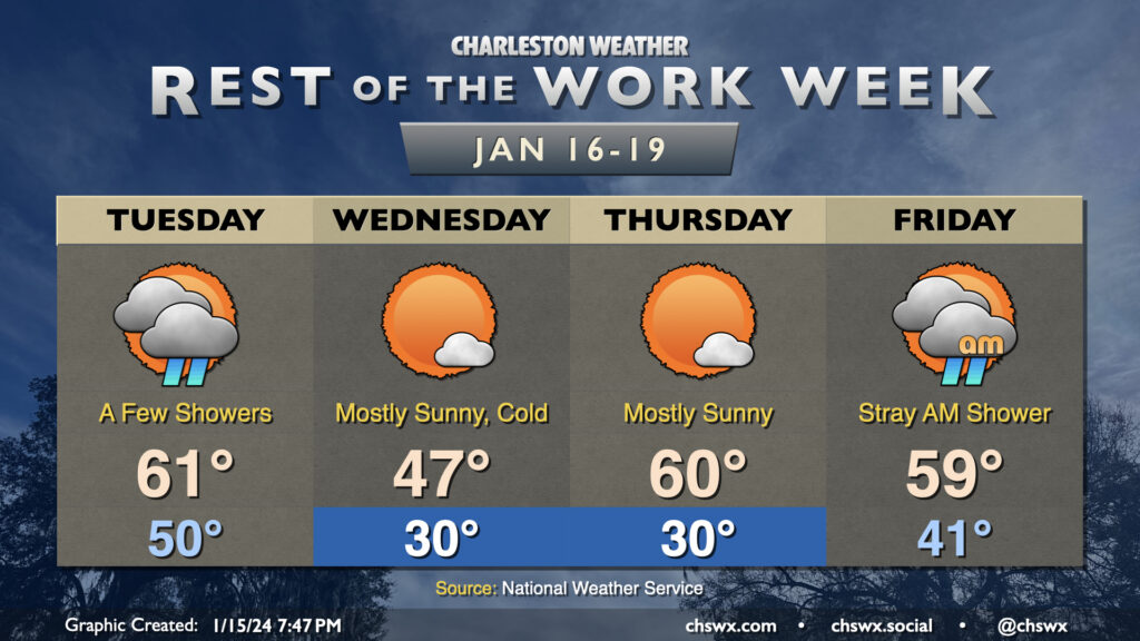
Temperatures will be somewhat fickle this week as a series of fronts move through the area. Tuesday will trend on the warm side, with lows around 50° to start the day heading into the low 60s in the afternoon as the first front moves by. A few showers will be possible along and ahead of the front, primarily midday through early evening. They won’t have much moisture to wring out, so expect the showers to be on the light side. From there, temperatures will plummet overnight.
We will most definitely know that a front has come through Wednesday morning. We’ll wake up to subfreezing temperatures across much of the area away from the immediate coast; breezy northwesterly winds will make it feel closer to the low 20s. The ongoing cold advection will prevent temperatures from reaching too far into the upper 40s in the afternoon despite mostly sunny skies.
Thursday gets off to a similarly chilly start (though with less wind, at least) as lows once again head toward around 30° (and likely colder further inland and in rural areas). However, the coldest air will be departing during the day, and temperatures head to around normal in the afternoon, generally running around 60°. The respite from the very cold air continues Friday. We’ll wake up in the low 40s and top out in the upper 50s to around 60° with a few morning showers possible as another front moves by, which brings the coldest air thus far this season into the area for the weekend.
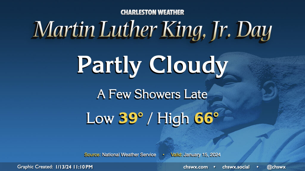
Martin Luther King, Jr. Day will be a generally quiet day of weather, with just a few showers potentially developing late. We start the day in the upper 30s, warming to the mid-60s (and maybe beyond) in the afternoon despite increasing cloud cover. Dry conditions should persist through sunset; thereafter, a few showers could move into the area as a front approaches. Overall, though, outdoor activities look to be generally okay and rain-free.
Slight shower chances persist as we head into Tuesday. Another front will then send some very cold air our direction. We’re going to feel it big-time on Wednesday as we wake up to air temperatures around freezing, but the westerly wind around 10 MPH will make it feel much colder (think low 20s). Strong cold advection will keep temperatures limited to the upper 40s in the afternoon. After a freezing start Thursday morning, temperatures recover to near 60° in the afternoon under partly cloudy skies. Another front swings through Friday, and that’ll usher in another round of even colder air over the weekend. Pipe-busting lows in the 20s could be quite common, particularly Sunday morning, with highs topping out just in the low 40s. Stay tuned to forecast updates this week as more data comes in.
Quieter weather returns to the area for the weekend, and not a moment too soon. We start Saturday in the mid-40s, but a breezy westerly wind will keep temperatures suppressed to the mid-50s despite partly cloudy skies as cool air blows in behind a cold front. Cloud cover decreases overnight and winds calm down, allowing for decent radiational cooling conditions for Sunday morning, when temperatures look to fall back to the mid-30s (and maybe near freezing in more rural areas). It’ll be a brilliantly sunny day, and temperatures will respond nicely, heading into the low 60s in the afternoon. Quiet weather should prevail for much of Martin Luther King, Jr. Day, too, with only a few showers possible after sunset; the better risk for rain arrives Tuesday.
Another storm system will impact the area on Friday with gusty winds and some showers and storms in the afternoon and evening hours, with a few pockets of severe weather possible, but certainly not the widespread threat that we saw on Tuesday.