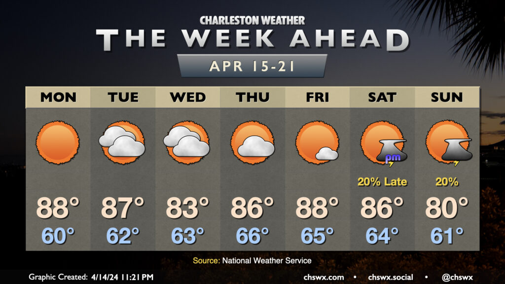
Charleston Weather Blog

Forecast explanations, atmospheric science, and other cool weather-related stuff for Charleston, SC

Tuesday: Clouds and rain are gone, but chill and wind remain

/ February 5, 2024 at 7:40 PM

Showers have ended and cloud cover will diminish overnight, yielding a sunny Tuesday — in stark contrast to the dreariness that was Monday. However, high pressure trying to build in from the west will help to keep the gradient pinched as low pressure remains offshore, keeping north to northeast winds elevated throughout the day. Temperatures will start in the upper 30s, but the wind chill will make it feel more like 30°, so dress appropriately in the morning. We’ll warm only to the mid-to-upper 50s despite the sunshine, too.

The other issue for Tuesday will be the risk for some minor to moderate coastal flooding very early Tuesday morning. High tide around 4:32am is forecast to reach between 7.5-7.7′. While we fell just short of coastal flood criteria Monday morning, it certainly seems more likely that we’ll achieve flood stage on Tuesday. So, if you have early travels that take you downtown, be ready to reroute around flooded roads.

Read more »

The week ahead: Stormy start, then turning cool and quiet

/ February 4, 2024 at 11:57 PM

The first full week of February gets off to a stormy start as strong low pressure affects the area, particularly in the morning. We’re looking for the potential for some coastal flooding early in the day, and this combined with heavy rainfall could cause flooding problems across downtown Charleston, especially around high tide a little after 3:30am. A Coastal Flood Advisory is in effect from 2-6am for the salt water flooding threat; if that heavy rain does coincide, additional flood advisories for land-based areas would be needed. Rain does slowly taper off as Monday goes along, but we stay on the chilly side as breezy northeasterly winds blow in. This keeps highs capped to the mid-50s after an upper 40s start.

Read more »

Sunday: Turning breezy and unsettled as a storm system approaches

/ February 3, 2024 at 9:32 PM

Our run of quiet weather comes to a brief pause starting Sunday as a storm system approaches the area. We’ll see cloud cover head up throughout the day, and showers will be increasingly possible as we get into the later afternoon and evening hours. Expect temperatures to start in the upper 30s to around 40°, with highs topping out around 60°. Northeasterly winds around the storm system will be increasing as the day goes on, and it could be a bit gusty by afternoon, so keep that in mind as well as you head out and about.

Read more »

Weekend forecast: Saturday the pick day to get outside as a storm affects the area Sunday

/ February 2, 2024 at 8:15 PM

This stretch of quiet weather culminates in a sunny and a bit cooler day on Saturday. A front will come through overnight Friday into early Saturday morning, kicking up the winds a little and swinging them around to the northeast. Temperatures Saturday start in the low 40s, but will only warm to about 60° despite nearly cloudless skies during the day.

Sunday will be a different story. We’ll stay on the cool side with strengthening northeasterly winds throughout the day — expect highs to top out in the upper 50s to around 60° in the afternoon — but cloud cover will be on the increase as a storm system approaches from the west. Showers will advance on the area throughout the day, and we should start to see some showers by early afternoon. Rain will pick up later in the day and especially after sunset. As low pressure to the west and high pressure to the northeast continue to butt up against each other, the pressure gradient will pinch and winds will subsequently increase. We should see gusts to 30 MPH by sunset, and this will continue overnight as rain falls. The rain could be heavy overnight; by the time moisture shunts offshore during the day Monday, some spots could receive an inch and a half of rain with even higher amounts. There will even be a risk for some tidal flooding early Monday morning as well, but it should peak well before commute time. Keep an eye on forecast updates as the details become further refined.