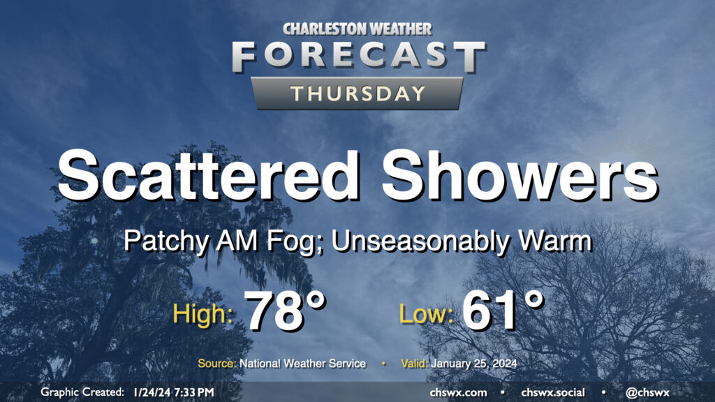
We hit 77° at the airport on Wednesday, narrowly missing a record high by two degrees (79°, set in 1950 and tied in 1974) and making this the warmest day so far in this young year. We have a chance to top that on Thursday despite showers working their way into the area as we stay within the broad warm sector of a storm system in the mid-South. We should start the day with some patchy fog as lows fall to the low 60s, right around the normal high for this point in the year. Temperatures will then warm to the upper 70s, and there’s a more-than-decent shot that some spots reach 80°. (The record high for January 25 is 82°, set in 1949.) A few showers will be possible across the area during the day, but coverage should be relatively sparse.
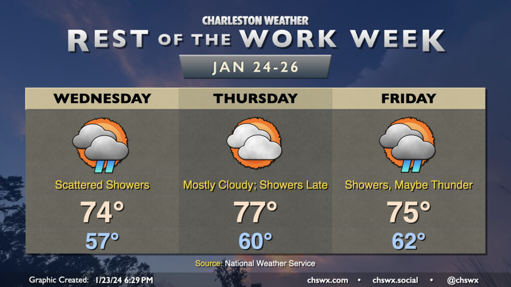
The warming trend continues Wednesday as a warm front lifts north of the area. Temperatures start in the mid-to-upper 50s owing to cloud cover blanketing us for much of the night. Once the warm front shifts ashore and winds go southeasterly, temperatures will respond further and head to the mid-70s. It’ll be kind of muggy, too, with dewpoints in the mid-60s expected behind the warm front. Scattered showers will remain possible throughout a fair bit of the day, though we should see more sun than we did Tuesday (not hard to do, tbh).
At a minimum, we’ll get the first part of Thursday in rain-free, if not the vast majority of it, before a front approaches the area and reintroduces shower and storm chances for Friday. Temperatures will peak Thursday, with lows in the low 60s and highs topping out around the mid-to-upper 70s. There will be a chance for a few showers late, but most of us should stay out of that until Friday, when shower coverage looks to increase with some thunder possible as well. Severe weather currently doesn’t appear to be a concern, though, as wind fields are largely unimpressive and instability appears meager. Temperatures on Friday will be tamped down a little by the shower activity, “only” reaching 75° after starting in the low 60s once again. We stay in the 70s on Saturday, but a second, stronger front will restore order to temperature chaos on Sunday, and by Monday, expect temperatures near normal with much more sunshine.
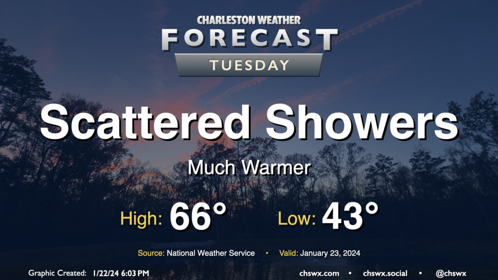
After a day in which we warmed up some 14° compared to Sunday with a high of 60° at the airport, the warming trend continues for Tuesday and beyond as surface high pressure continues to move offshore. Temperatures on Tuesday start in the low-to-mid-40s — roughly where we were for a high on Sunday — and warm into the mid-60s in the afternoon under mostly cloudy skies. A few showers will be possible at times, but any rain will be generally light. Still, y’all know how traffic can get even with the lightest of rain, so prepare accordingly.
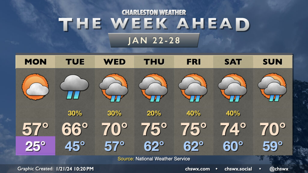
After a quite chilly weekend, we will be thawing out very quickly as we get into the new work week. Monday gets off to one more frigid start with lows in the mid-20s. From there, though, we start to see the arctic airmass begin to modify as a ridge builds aloft and surface high pressure shifts offshore. Monday’s high goes into the mid-50s, much warmer than we were at any point over the weekend. Then it gets downright spring-like: Tuesday warms into the mid-60s after a mid-40s start, and by Wednesday we’re in the 70s. Mid-70s take hold Thursday through Saturday ahead of a cold front, which should help to bring temperatures down a touch by Sunday.
The only fly in the ointment will be scattered shower chances beginning Tuesday and really lasting for the next few days as we sit between an upper trough to the west and ridging to the east. This will transport moisture and occasional upper-level disturbances into the area, and a surface trough along the coast will help act as a focal point for shower development. It won’t rain all the time or all day at any one spot, but all the same you’ll want rain gear handy just in case, especially heading into the weekend as the aforementioned front approaches.