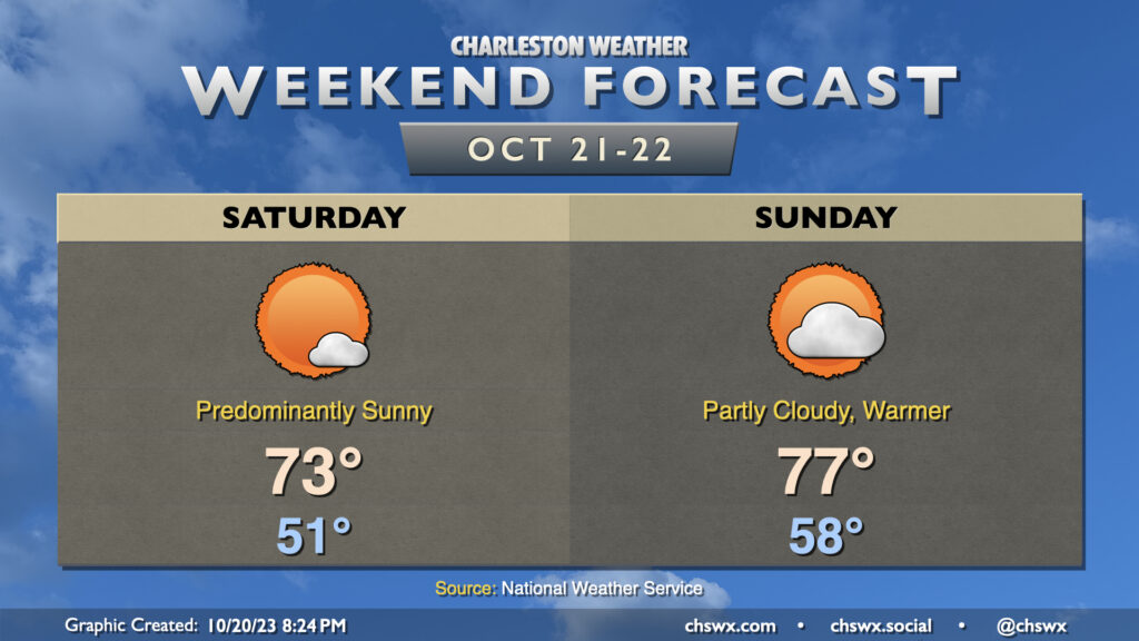
After an occasionally stormy Friday, we have a great looking weekend of weather ahead. Skies clear out overnight Friday in the wake of the front, and by Saturday morning, we’re waking up to brilliant sunshine and temperatures in the low 50s. It’ll be a predominantly sunny day with temperatures topping out in the low-to-mid-70s.
Sunday turns a little warmer, but it’ll remain rather comfortable. Lows in the upper 50s give way to highs in the mid-to-upper 70s in the afternoon with a few clouds at times and a gentle northwesterly breeze. A reinforcing front makes a dry passage late Sunday evening, and this will cool temperatures back down for Monday. Peeking ahead into the forecastable future, there’s very little sign of much in the way of rain as we get into the home stretch of October. This isn’t too abnormal as October is climatologically a fairly dry month here in the Lowcountry, but we are almost an inch off pace still for the month.
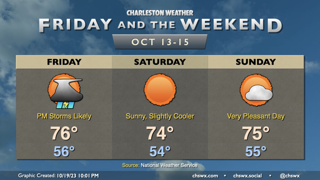
Showers and a few thunderstorms re-enter the weather picture for Friday as a cold front moves by, but it’ll be worth it as we have a gorgeous weekend ahead.
We start Friday in the mid-50s with dewpoints steadily rising throughout the day. Showers and thunderstorms will approach the area from the west as the day goes on, with storms possible perhaps as early as 1-2 PM, but most likely in the late afternoon to early evening hours. A storm or two could even be on the strong side, with damaging wind gusts the main concern. Rainfall between a quarter and half-inch is generally expected, with some spots under- and over-performing as is common with these kinds of convective setups. Due to the ongoing dry conditions, though, flooding is not expected to be an issue.
From there, the weekend looks great. Skies clear nicely for Saturday, and northwesterly flow will yield a rather beautiful day with lows in the mid-50s yielding to highs in the mid-70s in the afternoon with nary a cloud to be found. Sunday will be another really nice day with temperatures generally similar to Saturday’s, though we’ll see a bit more in the way of scattered clouds ahead of a dry frontal passage late. All in all, it looks to be a fantastic weekend to get out and do stuff.
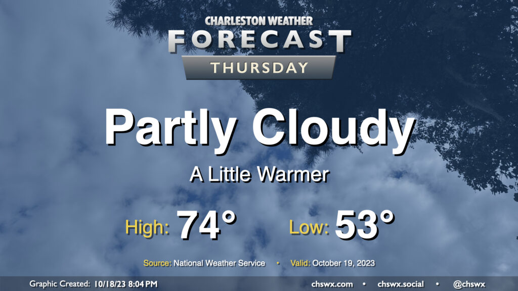
Expect clouds to be on the increase on Thursday as a coastal trough develops nearby, spreading some cloud cover onshore. Somewhat more southerly trajectories will allow temperatures to run a little warmer (but still below normal). Expect to start the day in the low-to-mid-50s before temperatures head to the mid-70s in the afternoon. Despite increasing clouds, expect one more rain-free day ahead of a cold front arriving Friday.
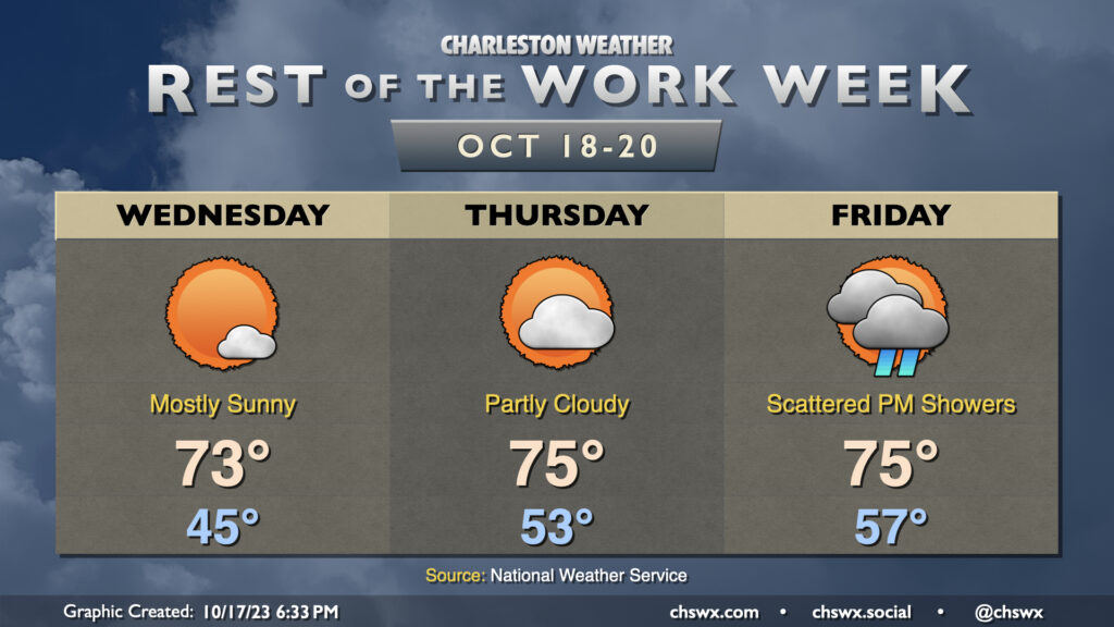
Sun continues for a couple more days before unsettled weather arrives later Friday with a cold front. Wednesday could be the chilliest start since April 18 if the NWS forecast verifies, with low to mid-40s common away from the locally warmer coastline. Temperatures will warm into the low 70s under mostly sunny skies, a couple clicks warmer than was observed on Tuesday.
Thursday runs even a little warmer as winds go a little more east to southeast, allowing some more moisture to work into the area. Expect to start Thursday in the low 50s before warming to the mid-70s under generally partly cloudy skies.
Our next rain chance arrives Friday afternoon into the evening ahead of a cold front. This will be the warmest overall day of the set as lows generally start in the mid-to-upper 50s before reaching highs in the mid-70s in the afternoon before showers begin. Right now, it doesn’t look like we’ll get much in the way of rain; generally around a quarter-inch at most. Of course, that doesn’t preclude a few spots from seeing some slightly heavier or lighter amounts.
Once the front is through, we have an excellent, seasonable weekend of weather on tap with lows in the low 50s and highs in the low 70s each afternoon with plenty of sunshine.
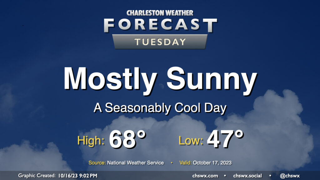
Tuesday will be another seasonably cool day under mostly sunny skies as high pressure remains in control at the surface with troughing aloft. After an upper-level disturbance passes by overnight Monday, skies will clear, allowing temperatures to fall into the upper 40s away from the coast for Tuesday morning. Temperatures then rise into the upper 60s, with the potential for a couple spots to hit 70°. Overall, a very seasonable October day across the Lowcountry.
Overall, we’ve got a pretty nice week ahead with temperatures running generally below normal and only one passing rain chance on Friday.
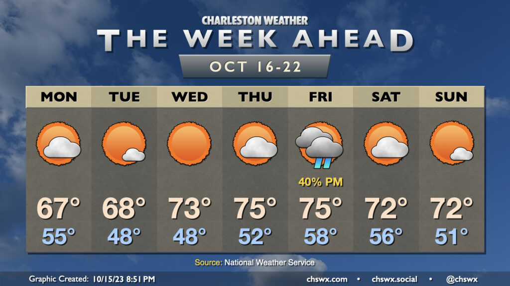
A trough moving by overnight Sunday into Monday could bring a few showers early Monday morning, but those will be done by daybreak, and we should see a partly cloudy day with highs topping out only in the mid-to-upper 60s, some 10° below normal for this point in the year. (Might be a little taste of sweater weather?) We start Tuesday in the upper 40s with highs once again peaking shy of 70° with more sunshine expected. We have a similarly cool start Wednesday but with unfettered sunshine, expect highs to top out in the low 70s. Thursday runs a little warmer with lows starting in the low 50s and highs in the mid-70s with a little bit more in the way of cloud cover (but still plenty of sun, too).
Our only real rain chance this week arrives ahead of a cold front on Friday. Generally, expect a scattering of showers in the afternoon and evening ahead of the front, but nothing too outrageous. Highs will run in the mid-70s. Behind the front, a modest cooldown will ensue, but it should be a really nice weekend with lows in the 50s and highs in the low 70s each afternoon.