Charleston Weather Blog
Forecast explanations, atmospheric science, and other cool weather-related stuff for Charleston, SC
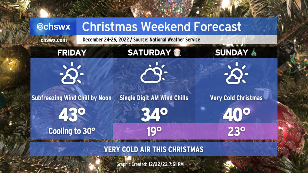
A very potent cold front will be coming through early Friday, bringing strong, gusty winds, dangerous wind chills, and several mornings in a row of pipe-busting cold for the Christmas holiday weekend.
Read more »
Low pressure is quickly lifting to the north. After briefly touching 63° about an hour ago, temperatures at Mt. Pleasant are dropping back into the 50s.
Rain should be done for today at this point. Temps should rebound to the mid-50s for all of us later today.
Complex surface setup this morning with a tight temperature gradient across the metro area. We’re in the mid-40s in Summerville and Moncks Corner, but temperatures have surged into the low 60s at Mt. Pleasant, where a warm front has come ashore. Suspect low 50s at the airport may come down a tick or two.
Looks like the water level peaked at 8.31’ MLLW at 7am, which if verified will be the 14th highest tide on record at Charleston Harbor, and the third major coastal flooding event of 2022. Expect salt water flooding to recede over the next couple hours.
Water level is now up to 8.3’ in the harbor as of 6:42am. This is good for 14th highest on record. Major coastal flooding ongoing that may be having impacts beyond downtown at this point; please send reports!
The water level in Charleston Harbor as of 6:24am was 8.19’, tying October 18, 2020 for 18th highest tide on record. Still some time for water levels to increase, too.
The water level in Charleston Harbor has exceeded major flood stage (8’) for the third time in 2022. Expect this to continue to climb for the next half hour as we head toward high tide at 6:37am. There is rain in the area, too, which may expand the flood threat downtown.
Water levels in Charleston Harbor have exceeded flood stage for the 70th time in 2022. High tide isn’t expected to peak for another hour. With rain in the area, expect road closures and overall traffic issues downtown through 9-10am.
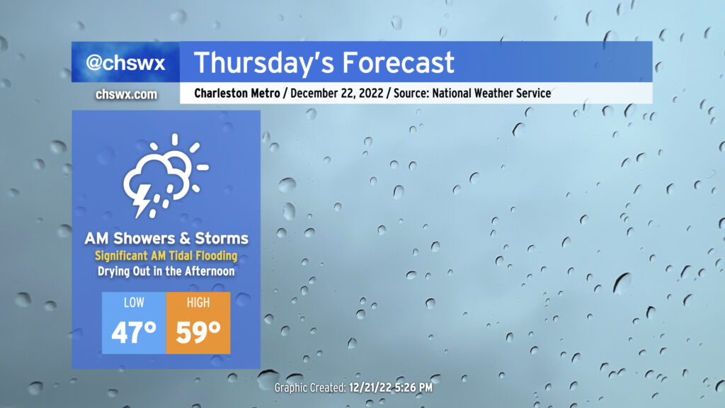
Thursday will bring somewhat complex weather to the Lowcountry with a very soggy start to the day as low pressure moves across the area, followed by a dry slot moving into the area in the afternoon to shut off the rain. Of course, we continue to monitor the progress of an incredibly potent Arctic cold front as it progresses across the country, with it expected to clear our area on Friday.
Read more »
With a peak water level of 7.48’ this morning, 2022 is now the second-most active coastal flooding year on record (water level > 7.0’ MLLW in the harbor) with 69 events. 2019’s 89 events still stands as #1. Records begin October 1921.
Posts navigation