Radar continues to show light to moderate rain moving across much of the Lowcountry late this evening, with some embedded pockets of heavier rain. Showers and a few thunderstorms will remain possible for the next couple hours before tapering off after midnight. Most of this should be out of here by 2-3am.
The risk for severe weather has ended across the Charleston Metro Area, and tide levels continue to retreat after peaking shy of 6.4′ MLLW earlier this evening, so there are no further major weather concerns tonight.
Many spots saw over 1″ of rain based on reports. It’s much-needed, and it’s sure great to get it without all the extracurricular activity. We’ll have a few days to dry out before the next risk for rain arrives later next week.
We are largely hitting a lull in the rain across the area early this evening. Temperatures have settled into the mid-60s across the area, with skies remaining very overcast. Today’s rain has tamped down the severe weather threat pretty well, and with light showers still in the area and the amount of daylight waning, we should be in decent shape. Given the dynamics, one cannot totally rule out an isolated storm with gusty winds or hail, but the risk is very low.
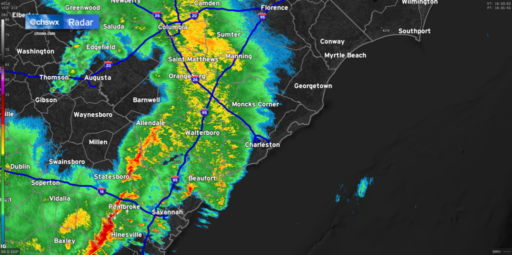
Our next round of rain is likely taking shape to our west, where the airmass did get time to recover and another round of strong to severe thunderstorms is ongoing. This activity will weaken as it heads eastward, but may hang on enough to bring more substantial rain into the area. Radar estimates suggest that we’ve generally received anywhere from .25-.75″ across much of the Tri-County, with the highest amounts in southern Charleston County as well as between 17-A and I-95 in Berkeley and Dorchester counties. It’s been a pretty decent soaking, and the good news is that there have been no flooding concerns of note so far.
Based on current timings, it looks like we will get past high tide before any more heavy rain moves in, which is good news for downtown. Of course, we’ll keep an eye on things until the cold front swings through late tonight, but so far, it’s turning out pretty good for us.
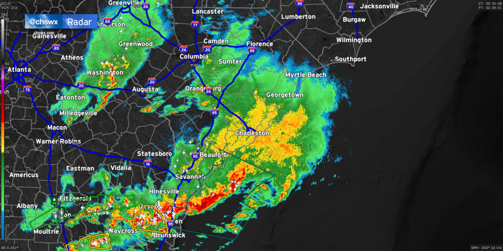
It’s been a while since there’s been anything of consequence on radar, but we are beginning to see some rainfall move into the Tri-County from the west now. Some embedded downpours and rumbles of thunder are certainly possible, but the severe weather threat remains low and should stay that way through the evening. Now that we have seen how storms are evolving, the risk for severe weather looks greatest along and south of Interstate 16 in Georgia. A tornado watch is up for Southeast Georgia until 6PM as a squall line moves through. This line stretches from Georgia southwestward into Florida, with the worst of the weather looking to stay south of the Charleston Metro Area.
A couple more rounds of heavy rain are possible through this evening, and we will still need to watch the 6:43 PM high tide very closely for the potential for flooding, especially if heavy rain is ongoing at that time. There remains a marginal risk that one or two storms could still become severe, too, so be sure you can still receive warnings this afternoon and evening. However, a widespread severe weather event is becoming increasingly less likely.