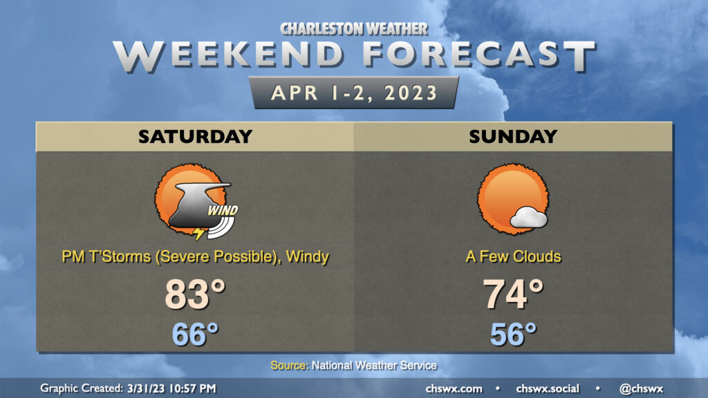
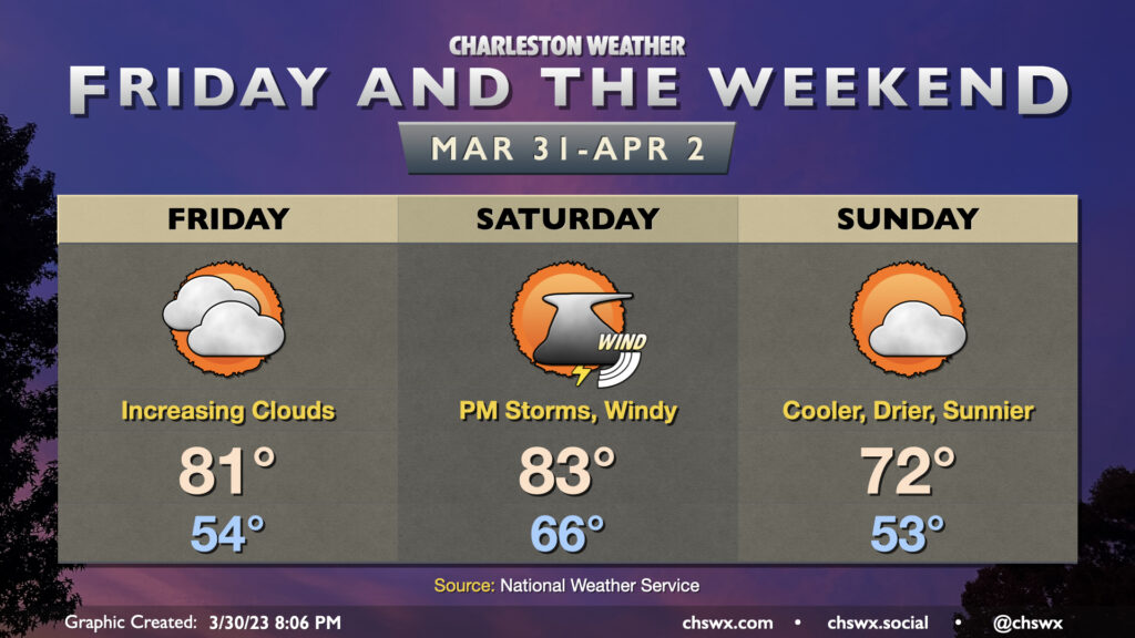
A cold front will be working its way eastward into the metro area throughout the day Saturday, but its associated rainfall will arrive in the late afternoon and early evening, sparing the Bridge Run. It’ll be windy; gusts 30-35 MPH will be possible especially heading into the early afternoon, and this may contribute a bit of a headwind at times during the race. After starting in the mid-60s, temperatures should head into the low 80s in the afternoon ahead of the cold front.
A line of showers and thunderstorms will precede the cold front. It should be losing some steam with the bulk of the energy staying well north, but there is ample wind shear and should be enough instability for a few of these storms to be on the stronger side with wind damage the main concern. Some hail and even a tornado can’t be totally discounted, either, so you’ll want to make sure you have ways to get warnings tomorrow. These look to get into western parts of the Tri-County in the 3-5 PM timeframe, pressing off the coast by 6-7 PM with showers to fall for a little while afterward.
Once the front is through, cooler and drier air works its way into the area. Overall, Sunday should run about 10° cooler than Saturday with a lot more sunshine. It’ll be the pick day of the weekend for outdoor activities with comfortable warmth and low humidity.
Our warming trend continues Friday ahead of a cold front that’ll arrive here Saturday evening with a few showers and storms out ahead of it. (We still look okay for the Bridge Run, though.)
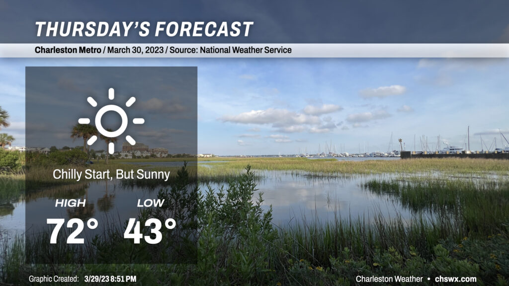
Calm winds and clear skies will allow temperatures to fall quite nicely tonight, with lows bottoming out in the low 40s across much of the metro area to start Thursday. (Thankfully, not low enough to deal with frost or freeze concerns.) Full sunshine will allow temperatures to warm nicely into the low 70s, making for what should be a rather pleasant day across the Lowcountry.
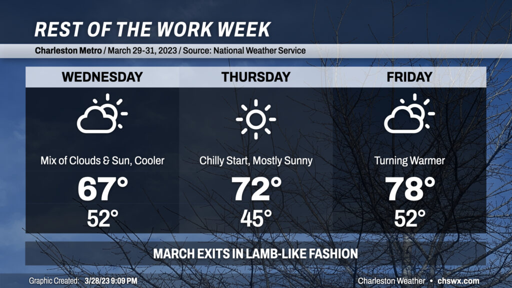
The final few days of March 2023 will be generally quiet, weather-wise (at least here in the Lowcountry), as a cold front moves across the area overnight and ushers in a cooler, drier airmass. Wednesday will be much cooler than recent days with highs peaking in the mid-60s. We’ll see a mix of sun and clouds throughout the day as a little lingering low-level moisture hangs around, but that’s about it.
The aforementioned moisture strips out later Wednesday, yielding a brilliantly sunny sky on Thursday. We’ll get off to a chilly start thanks to calm winds and clear skies from the night before with lows in the mid-40s (far from frost or freeze concerns, thankfully). Highs will reach the low 70s. All in all, not a bad day to get outside and take a walk.
Winds go around to the south beginning Thursday and this will yield a warmer Friday. Expect temperatures to peek in the upper 70s under partly cloudy skies. The 18z runs of the models indicate the potential for some showers coming ashore Friday afternoon; we’ll keep an eye on this, but for now, the going forecast is for mostly dry weather as some of you head out to pick up your Bridge Run packets.