Friday & the weekend: Warm Friday, cold front brings showers and a few storms Saturday, cooler Sunday
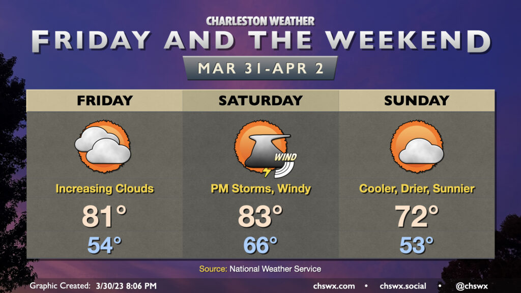
Our warming trend continues Friday ahead of a cold front that’ll arrive here Saturday evening with a few showers and storms out ahead of it. (We still look okay for the Bridge Run, though.)
After starting in the mid-50s, highs on Friday will soar into the low 80s despite increasing cloud cover ahead of the front. There’s a small chance for a shower or two to sneak onshore as well within the warm advection regime, but the vast majority of us should get Friday in rain-free.
Winds will increase ahead of the front on Saturday, with gusts 30-35 MPH possible late morning through the early afternoon. Highs could reach the low 80s once again, and that may yield enough instability for a few thunderstorms in the afternoon and/or early evening as the cold front moves on by. A strong storm with a damaging wind gust or two can’t be completely counted out given favorable shear, though a more widespread severe weather event will be blunted as the best forcing passes to our north.
The front will pass through Saturday evening, ushering in a somewhat cooler and drier airmass into the area. We’ll wake up to low 50s on Sunday as opposed to mid-60s on Saturday, and highs will top out in the low 70s under mostly sunny skies.
Bridge Run: Windy, muggy, but should stay rain-free
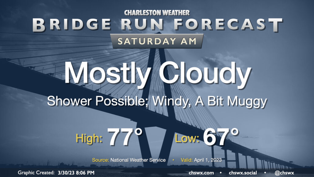
The expectation remains that we will get the Cooper River Bridge Run in rain-free. A shower or two will be possible in the morning, and any variances in the frontal timing will still need watching, but we should be okay for the race. Winds will almost certainly be a factor, with gusts 20-30 MPH quite common after sunrise; we may see even higher gusts on the bridge itself. Southwesterly trajectories will also make this a headwind, and it will be interesting to see the impact on race timings as a result.
Temperatures will bottom out in the mid-60s, making for a muggy but not unmanageable Bridge Run. Highs peak in the mid-to-upper 70s downtown ahead of the prefrontal band of showers and thunderstorms, which appears timed for the late afternoon/early evening hours (4PM on). Keep an eye to the sky during your post-race activities, but I suspect the main event will be fine.
Follow my Charleston Weather updates on Mastodon, Bluesky, Instagram, Facebook, or directly in a feed reader. Do you like what you see here? Please consider supporting my independent, hype-averse weather journalism and become a supporter on Patreon for a broader look at all things #chswx!