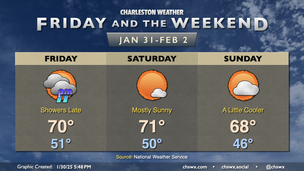
We stay well on the warm side of normal as we finally say goodbye to January and welcome February. Friday will be a mostly cloudy and breezy day ahead of a cold front. Despite the cloud cover, warm air pumping in from the south will drive highs back into the 70s in the afternoon. There will be a risk of showers primarily after sunset through the overnight across the metro area. If you have late Friday plans, be ready to possibly run into some rain. Amounts should generally be light as these showers should be booking it, and they should be gone before sunrise Saturday.
The front clears the area Saturday with some drier air moving in, though we should still see highs top out in the low 70s with much more sunshine. Sunday turns a little cooler as winds turn a little more onshore with high pressure wedging southward into the area. Still, expect highs in the upper 60s under partly cloudy skies — not too shabby, especially if we get caught in a classic Groundhog Day temporal loop. Enjoy!
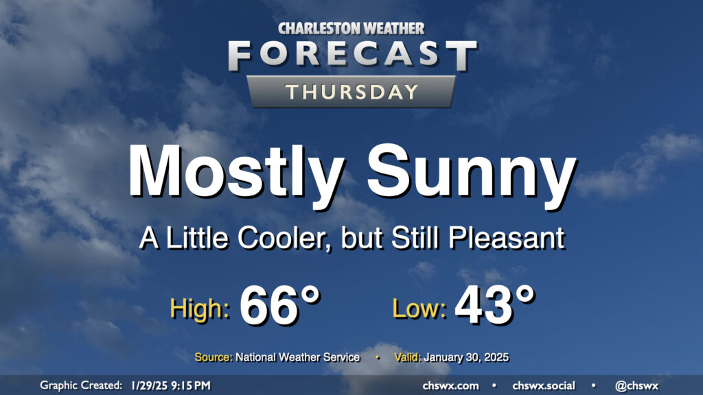
After the warmest day of 2025 so far, in which we reached 72° at the airport and 70° downtown, a dry cold front knocks our temperatures down a few degrees for Thursday, but it’ll still feel quite good outside. Expect mostly sunny skies to help low temperatures in the low-to-mid-40s warm to the mid-60s in the afternoon. An easterly wind at 10 MPH will keep things a touch on the breezy side, but otherwise, no concerns for Thursday.
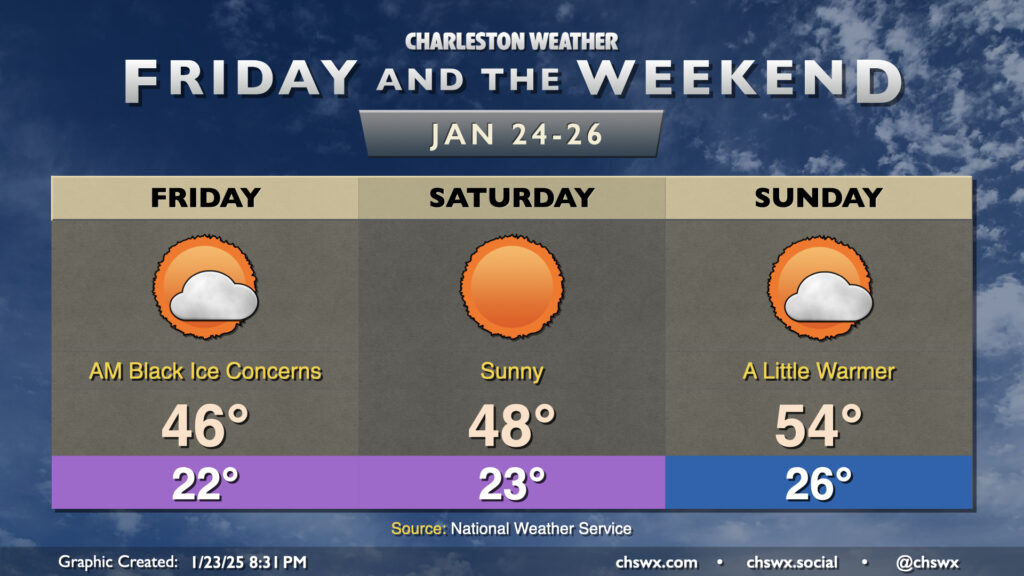
Snowpack is heading into its third day here in the Lowcountry, with many roads still a little on the sketchy side and black ice being a concern once again overnight Thursday into Friday morning. It’s kept us on the chilly side, too: the high today hit 40° at the airport, while the high of 38° at downtown Charleston was a record cold high temperature for January 23. We’re already back into the 20s as of this writing (8:45 PM-ish) with temperatures expected to fall into the low 20s given much less cloud cover than last night and the continued snowpack. Winds a little more out of the west should kick in on Friday, though, and we should see highs peak in the mid-40s along with more sunshine than we saw Thursday. Still, melting during the day Friday should once again contribute to a black ice threat overnight into Saturday morning, so keep that in mind if you head out.
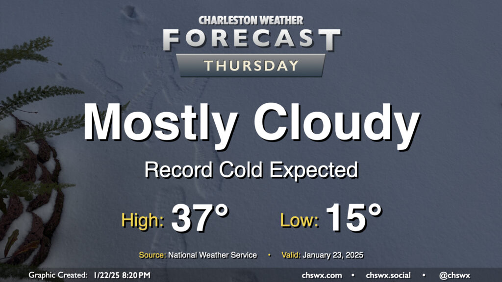
With plenty of snowpack still on the ground, expect a very, very cold night that should set daily records on Thursday morning as lows could fall to as low as 15°. Mix in the persistent northerly wind and wind chills may fall into the single digits. If you’re headed outside tomorrow morning, be bundling up in lots of layers and be very careful for re-frozen ice on steps, sidewalks, and roads.
Additional cloud cover on Thursday isn’t gonna do us a lot of good in the melting department; highs should once again only peak in the upper 30s with mostly cloudy skies generally expected. Wind will remain a bit of a factor, and it’ll feel like the 20s for much of the daytime period.
Getting into Thursday night, I’d expect another round of refreezing and black ice concerns. If you don’t have to travel, it’s probably best to stay hunkered in one more day.
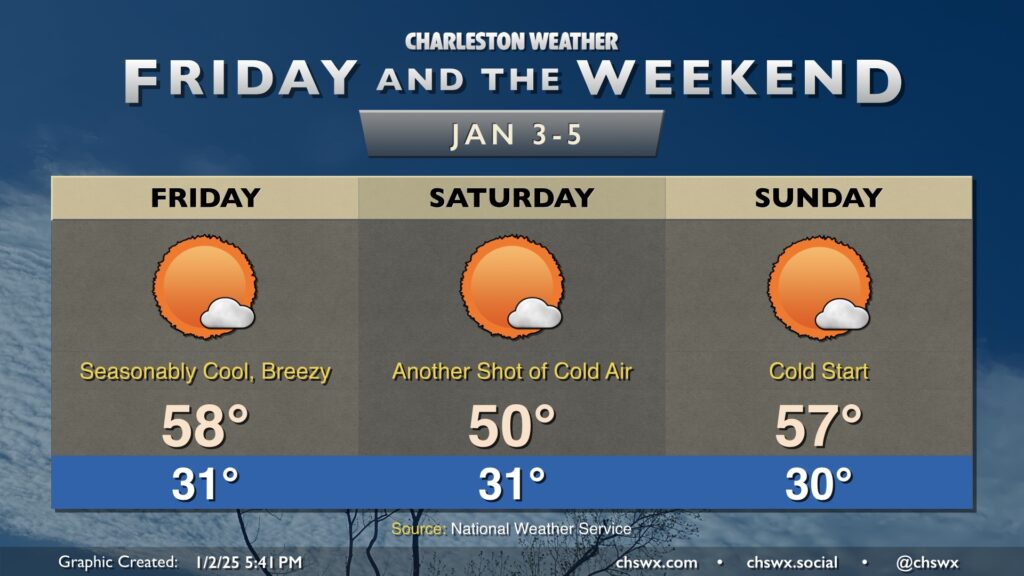
Friday will offer one more quiet day before an extended unsettled period kicks in starting this weekend, culminating in possible winter weather for the middle of next week.
We start Thursday in the upper 20s to low 30s across the metro, but temperatures will ultimately end up a few degrees warmer than Wednesday under mostly sunny skies. This will be the second to last day of generally quiet weather before an unsettled period begins this weekend and lasts into next week, which will turn very cold and perhaps somewhat interesting winter weather-wise, too.
Low pressure organizing in the Gulf of Mexico, just off the southern Texas coast, will move east and northeast heading into Friday, bringing snow and ice to the I-85 corridor and an otherwise raw, gross day of cold rain here to the Lowcountry. We start the day in the mid-20s, and recent guidance signals that there is a slight chance of a few snowflakes through about 10am as a band of precipitation moves north across the area, with the best chance of catching a few conversational flurries further inland around I-95, but they won’t last as temperatures at the surface and aloft warm up. No traffic impacts are expected (unless someone gets distracted by a snowflake, anyway). There should be a little bit of a dry slot in the early afternoon before more steady rain moves in from the west along with the low; this will keep us in the rain for much of the mid-to-late afternoon into the overnight. Highs on Friday will crack the low 40s but won’t warm much more, so again, be ready to bundle up and stay that way if you’re headed out. (Honestly, a great night to stay in with soup and a good movie.)
Thursday will be the coldest day of the week as a little reinforcing cool air moves into the area from the north. We start the day in the mid-20s, but the wind will factor in a bit more than the previous couple mornings, driving wind chills down into the teens across even the Charleston metro area. Thus, a Cold Weather Advisory will be in effect until 9am. Despite unfettered sunshine, highs will struggle to the mid-40s in the afternoon, and with the persistent north to northwest winds around 5-10 MPH, it’ll still feel like the upper 30s throughout the day. Layer up accordingly — you’ll be glad you did.
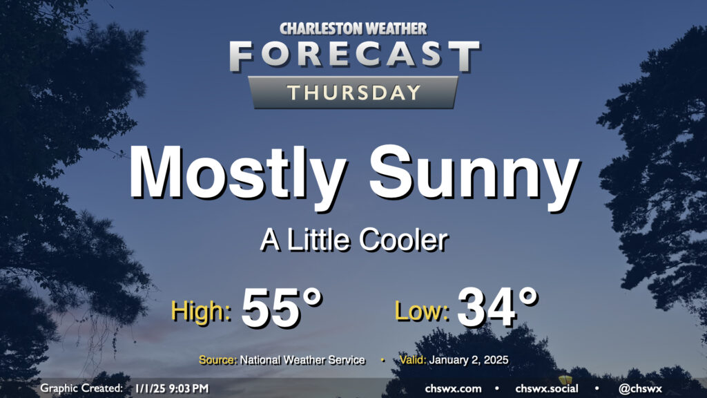
High pressure will be settling into the area overnight into Thursday, and this will drive a mostly sunny but seasonably cool day across the area. Expect lows in the mid-30s (with perhaps some freezing values in rural locations) to start Thursday, warming to just the mid-50s in the afternoon despite all the sunshine. Generally, temperatures will be running a few degrees below early January normals (normal high of 60°, normal low of 39°), but nothing terribly out of bounds.