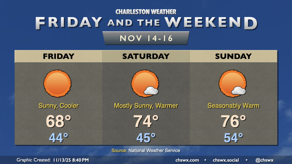
Quiet weather continues for Friday and the weekend as reinforcing high pressure arrives overnight. Friday will feel a touch cooler than Thursday did, with winds going back around to the north in the wake of a dry cold front. Lows Friday bottom out in the mid-40s, with highs peaking in the upper 60s in the afternoon under uninterrupted sunshine.
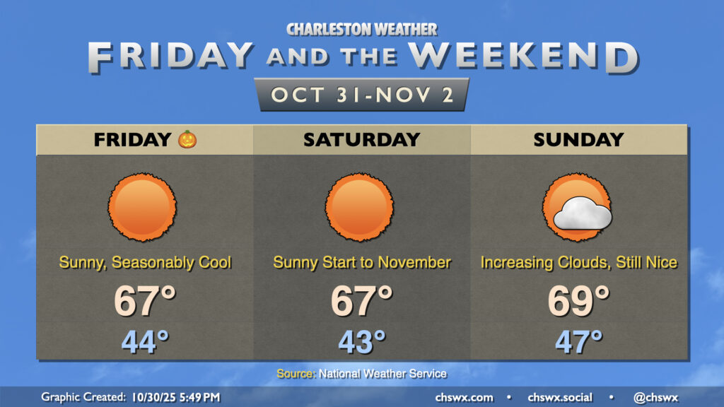
Halloween may be full of frights, but the weather won’t be one of them — seasonable and quiet weather is in store heading into Sunday with high pressure in control. Lows Friday bottom out in the mid-40s in the metro, with perhaps even lower temperatures further inland and in rural areas. We’ll warm to the mid-to-upper 60s in the afternoon with predominantly sunny skies and a gentle breeze out of the west. Saturday is essentially a carbon copy of Friday, though winds will be a little calmer and shifting direction out of the northeast and east. Don’t forget to set your clocks back an hour Saturday night as we fall back to Standard Time.
We’ll start to see dewpoints to climb back up and cloud cover begin to thicken as Sunday goes on in advance of the next storm system advancing out of the Gulf. Rain should hold off for the vast majority of the day, though a shower or two can’t be ruled out in the late evening. Temperatures on Sunday run a little warmer, with lows in the mid-to-upper 40s and highs approaching 70° despite the increasing cloud cover.
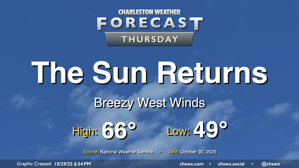
A cold front will swing through overnight, scouring out the clouds and ushering in drier high pressure behind it. It’ll be great to see the sun, which will make highs in the mid-60s feel quite nice. We’ll have a bit of a westerly breeze in the wake of the front, so keep that in mind if you have any plans to dine al fresco, but otherwise, it looks like a really good day of weather across the Lowcountry.
Expect generally quiet weather and seasonably cool temperatures to continue for Friday and the weekend. Dry high pressure remains in control for Friday with temperatures cooling to the upper 40s by morning, warming to the low-to-mid-70s in the afternoon with just a few clouds. High pressure then begins to wedge into the area over the weekend, bringing with it slightly cooler temperatures for Saturday. Moisture return ahead of the next storm system starts to kick in on Sunday, with dewpoints rising throughout the day contributing to a bit more in the way of cloud cover ahead of what looks to be an unsettled first half of the work week next week as low pressure heads up the coast.
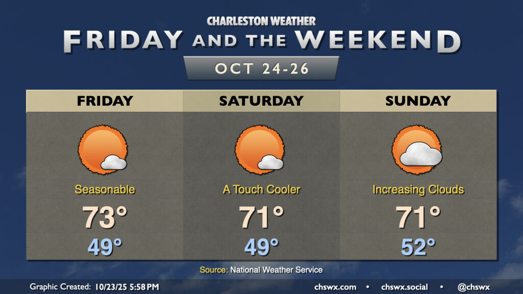
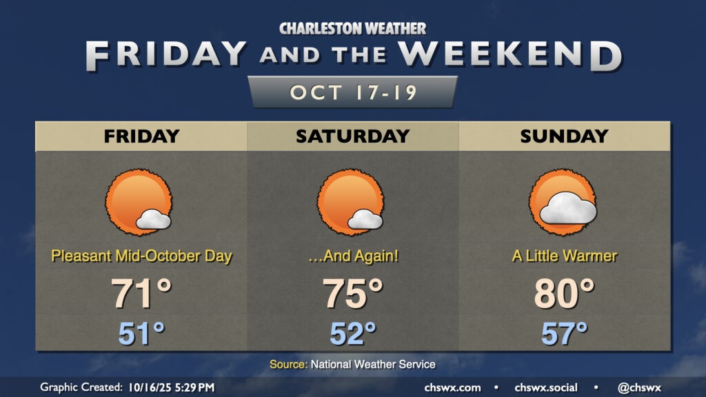
High pressure remains the main weather player in our neck of the woods, keeping things generally quiet and seasonable for Friday and the weekend. You may need a light hoodie or somesuch Friday morning as lows bottom out to the low 50s in the metro and perhaps into the 40s further inland and in more rural locations. Highs Friday peak in the low 70s with plenty of sunshine expected.
High pressure starts to move a bit more overhead Saturday and then starts to slip offshore on Sunday. This will lead to gradually warming temperatures through the weekend; mid-70s Saturday while we should touch 80° on Sunday. Generally speaking, mostly sunny skies will prevail, though there could be an uptick in cloud cover later Sunday as a front approaches. A stray shower will be possible overnight Sunday into early Monday morning, but otherwise, we look to stay dry well into next week.
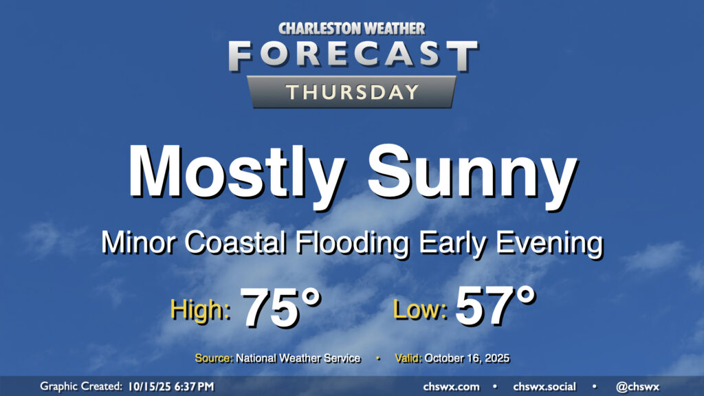
Mother Nature’s apology for the nor’easter continues Thursday with another day of comfortable temperatures and plenty of sunshine expected. A weak, dry front moves by early in the day, and so we should see temperatures start and peak a little cooler than we did on Wednesday. Expect lows in the mid-to-upper 50s warming to the mid-70s under mostly sunny skies. Winds will swing around to the northeast and pick up a little bit, and this could drive some minor coastal flooding with the early evening high tide cycle. A Coastal Flood Advisory is possible, but impacts beyond the most vulnerable locations downtown will be minimal.
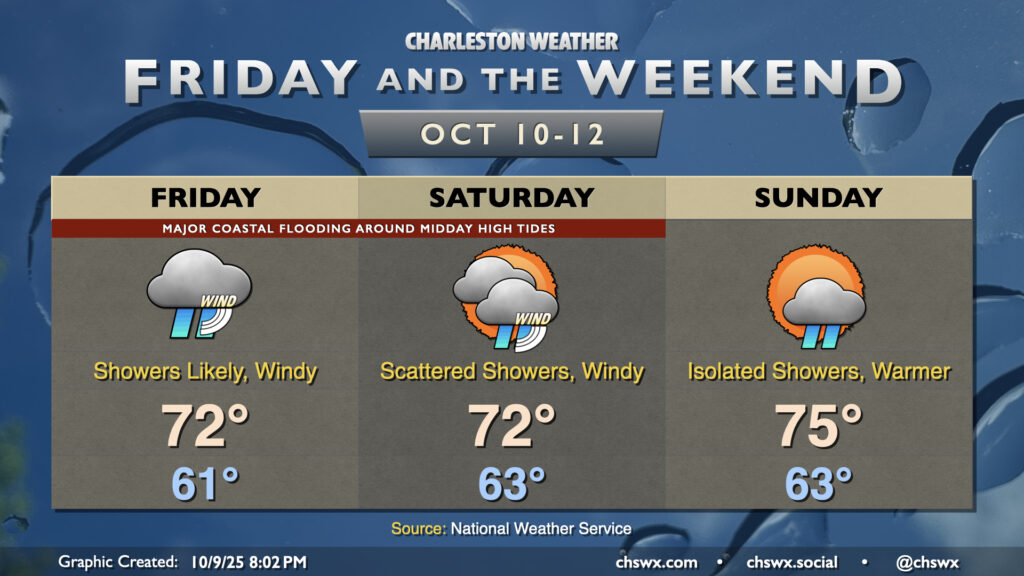
A non-tropical storm system spinning up offshore will bring wind and rain to the area along with major coastal flooding with the midday high tides Friday and Saturday. We’ll start to see some improvements Sunday, thankfully.
A cold front will pass through overnight, bringing with it a chance for showers and maybe even some thunder as it moves by. Behind that front will be a significant airmass change as high pressure builds southwestward into the area. We’ll wake up to lows in the mid-60s, with temperatures climbing just to the mid-70s under mostly cloudy skies. It’s going to be quite breezy, with northeasterly winds gusting 30-35 MPH at times, especially near the coast.
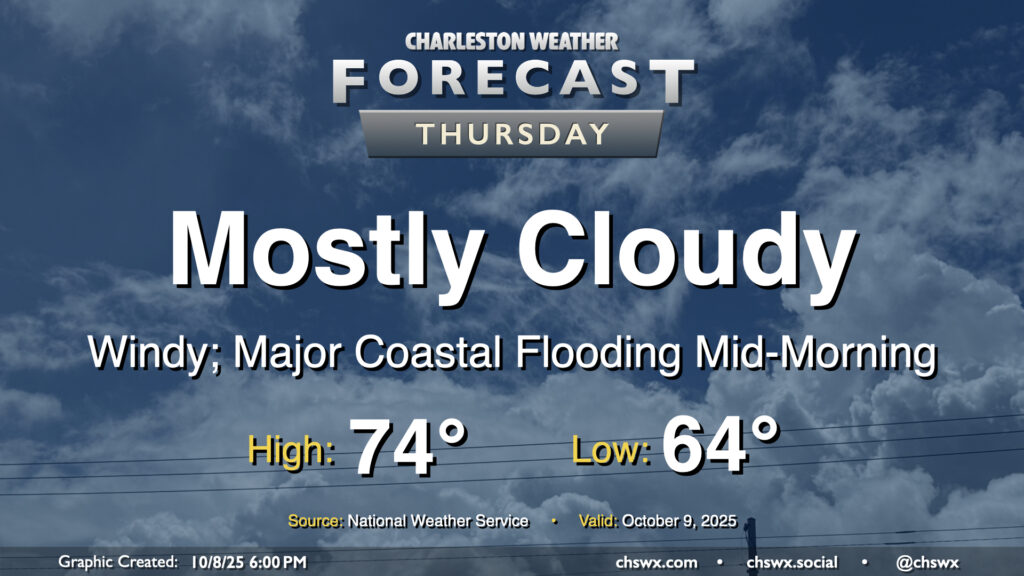
The strong northeasterly winds will drive water levels in the harbor quite high on top of already high astronomical tides, especially during the day on Thursday (and for the next several days). High tide will peak around 10:06 AM around 8-8.2′ MLLW, which is comfortably in the major flooding threshold. A Coastal Flood Watch is in effect and will likely be upgraded to a warning if trends continue overnight. Be ready for numerous road closures in downtown Charleston as well as salt water impingement onto roads on James and Johns Islands as well as Daniel Island. Moderate coastal flooding is expected with the evening high tide as well, with water levels peaking around 7.5-7.7 MLLW between 9 PM and midnight. This should be high enough for another round of road closures downtown, so be mindful if your travels take you there Thursday night.
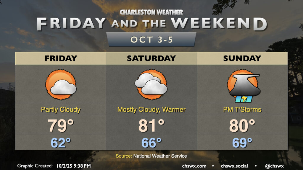
Temperatures will continue to be generally seasonable if not slightly cooler than normal for Friday and the weekend as high pressure continues to wedge southward into the area, though we will see an uptick in moisture and, eventually, rain chances heading into Sunday.
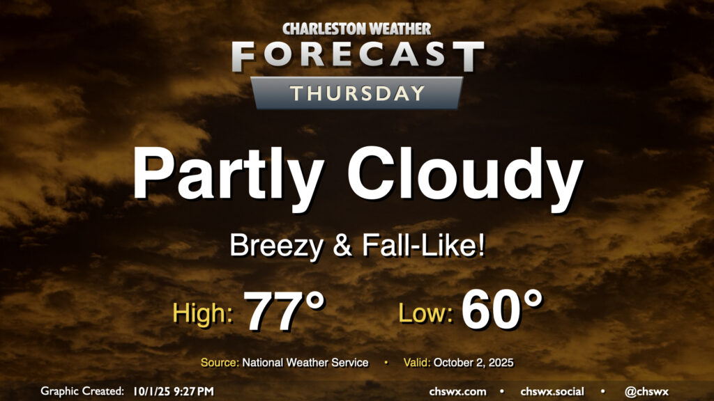
Thursday will give us a really nice taste of fall as cool high pressure wedges southward into the area. We’ll start the day with temperatures around 60°, warming to just the mid-70s under partly cloudy to mostly sunny skies. The northeasterly breeze will still be somewhat elevated, which may contribute to some minor tidal flooding around the 4:45 PM high tide. Otherwise, it’ll be an enjoyable day to get outside and touch some grass.