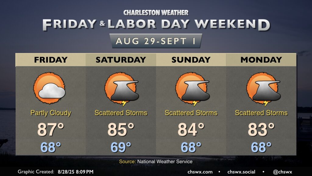
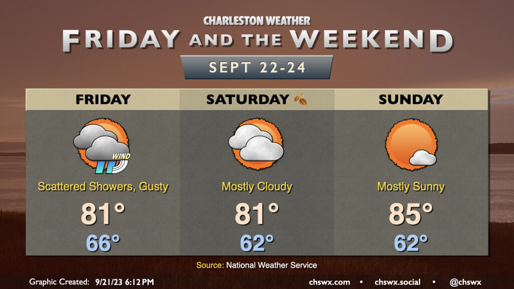
Friday is looking a little warmer but should remain rain-free as high pressure remains the main weather driver for at least one more day. Temperatures start in the upper 60s, warming to the mid-to-upper 80s in the afternoon under partly cloudy skies. An uptick in cloud cover and maybe a stray shower or two could accompany the seabreeze in the afternoon, but guidance keeps the majority of the area dry.
Shower and thunderstorm chances kick up a little bit for the weekend, though the trend has been a bit drier overall as high pressure to the north keeps the better rain chances further south. Still, waves of low pressure should at least kick up scattered coverage across the area especially in the afternoons, but it doesn’t look like a washout, and it will be a far, far cry from last weekend’s deluge. Temperatures will continue to run below normal; expect highs in the mid-80s each afternoon after starting each day in the upper 60s. It won’t feel much like summer as we unofficially bring it to a close, but it should still at least feel fairly pleasant when storms aren’t around.
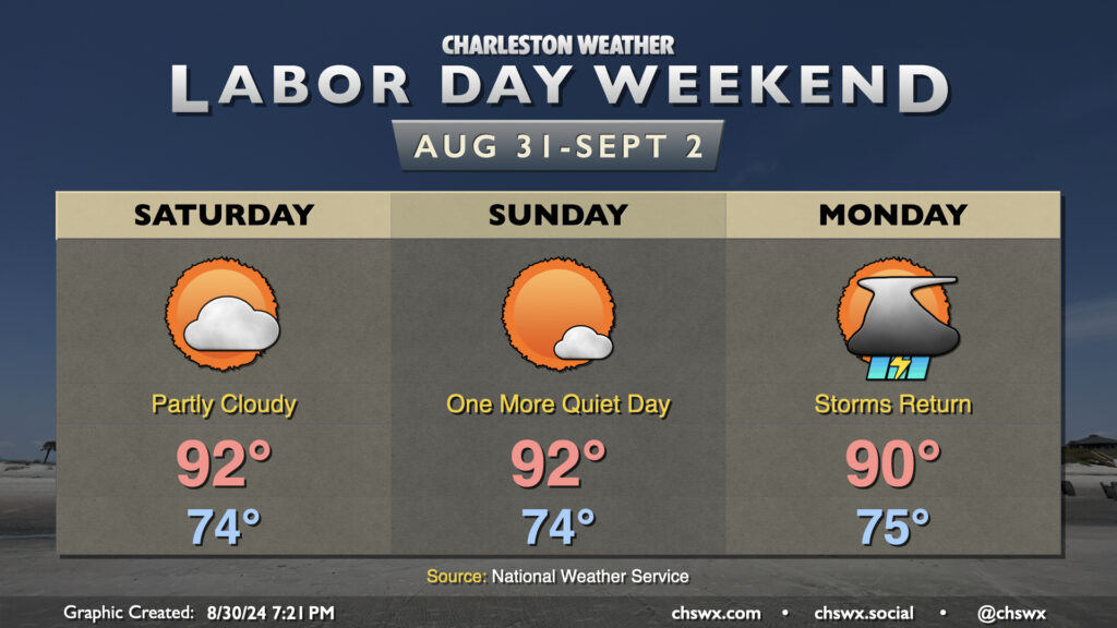
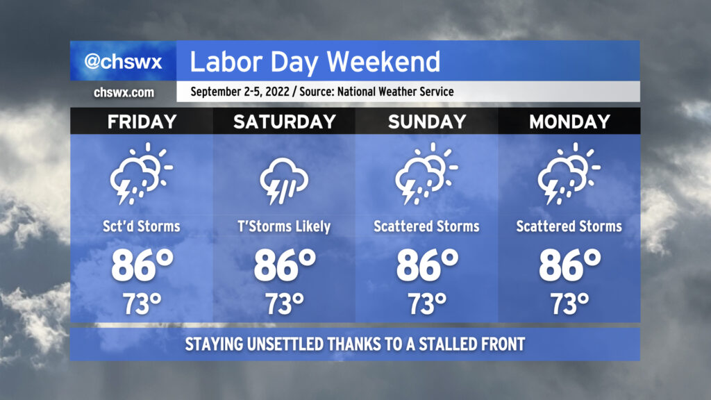
It’s a Meat Loaf-like Labor Day weekend this year: Two out of three ain’t bad. We’ll continue this stretch of warm but mostly quiet weather (aside from a stray shower on the seabreeze) for Saturday and Sunday. Expect to start each day in the mid-70s, warming to the low 90s in the afternoon. Heat indices will generally run in the upper 90s — certainly still hot, but it could (and has!) been much worse.
Attention then turns to a front that will move into the area on Monday. We’ll see the risk for showers and thunderstorms increase throughout the day as the front sags south into the region. Temperatures will peak around 90° one more time before the front ushers in cooler air and continued unsettled weather as we get into the working portion of next week. Severe weather doesn’t look to be a major concern, but we could see brief periods of heavy rain and lightning from any thunderstorm that fires. Remember: when thunder roars, go indoors!
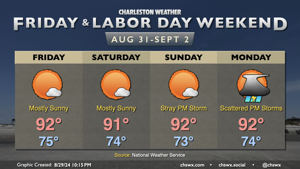
The good news is that much of the upcoming Labor Day weekend is looking pretty good: expect highs generally to run in the low 90s each afternoon, with heat indices in the upper 90s expected after taking into account dewpoints in the low to mid-70s. A stray shower or storm can’t be completely ruled out, especially as you head inland, but otherwise we should stay mostly quiet across the area.
A pattern change is in the offing, though, that will help drive a front toward the area for Monday. We’ll start Labor Day in the mid-70s once again, warming to the low 90s in the afternoon. As the front pushes southward, the risk for showers and thunderstorms will increase, with a decent shot at some storms arriving by Monday evening. This will kick off a stretch of unsettled — but cooler — weather as the front stalls to our south and high pressure wedges southward across the area. A nearby coastal trough should keep rain chances in place for much of next week, though we have a few more summery days to enjoy before then!
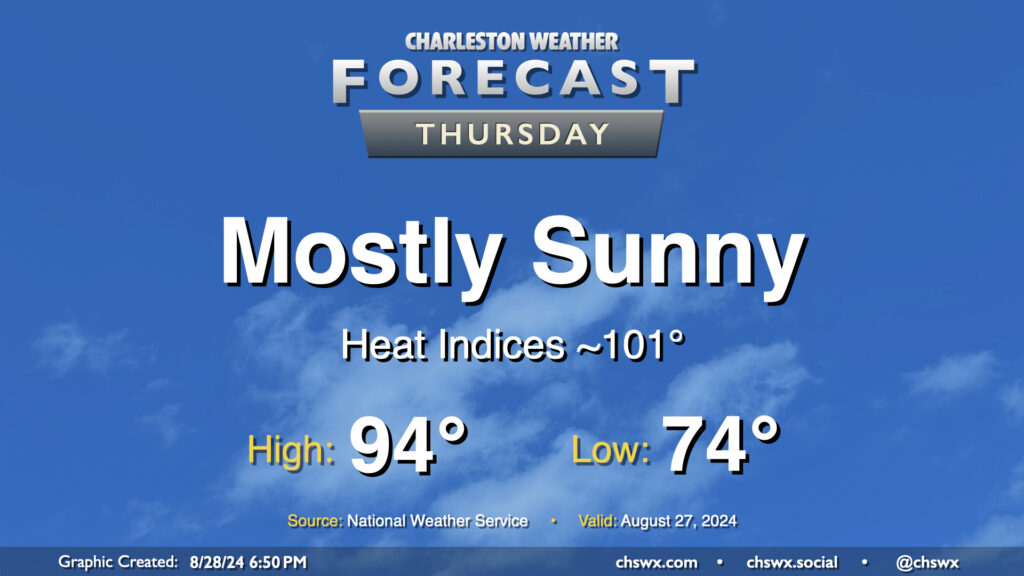
Our stretch of high-pressure-dominated weather continues on Thursday as warm temperatures and mostly sunny skies continue. We start the day in the mid-70s, warming to the mid-90s in the afternoon. Dewpoints in the low 70s will ultimately yield heat indices around 100-101°. A few patches of fog will be possible in the morning, but otherwise, another generally quiet weather day is expected.
Not sure if there are enough superlatives for how this Labor Day Weekend looks, weather-wise. Temperatures will be comfortably warm with reasonable humidity all weekend. Expect mid-80s Saturday and Sunday before we turn back toward 90° on Monday, though dewpoints in the mid-60s should negate any heat index impacts. Clouds will be few and far between, with predominantly sunny skies dominating. It’ll be a truly fantastic long weekend of weather, and I hope you can take advantage.
The only issue we’ll run into is some tidal flooding with each high tide cycle through Sunday morning. After Friday evening’s expected moderate flood, we’ll only see minor coastal flooding thereafter. You’ll simply want to keep an ear out for Coastal Flood Advisories from the National Weather Service so you know when the risk for a few closed roads will be highest.
Well, today was supposed to feature a lull in the shower and storm action, with more isolated coverage…and then it rained for five hours, flooding downtown Charleston again while 3-5″ of rain dumped on Johns Island and West Ashley. This was due to the combination of a stalled front and outflow from a thunderstorm cluster that developed to our northwest. Add in a little upper-level energy and you have a very, very soggy Thursday afternoon. Thankfully, the bulk of today’s rain is over and we should largely dry out overnight (though with fog a distinct possibility).
As we head into Friday, scattered storms remain in the forecast as the ever-present front remains close by. The impact on our weather will largely be driven by how far south it slips tonight into tomorrow. Right now, the expectation is that the greatest concentration of storms will be to our south and west, but I do anticipate that we’ll see a few more downpours tomorrow across the metro area, perhaps again having impacts on the evening commute.
Shower and storm coverage is expected to tick up a little bit more Saturday as onshore flow becomes a little more convergent at the surface. That’ll be the day with the greatest potential for persistent rainfall (at least as currently forecast). There is a little model disagreement with where the surface front will be, though, and so that’ll drive a little uncertainty. Heading into Sunday and Labor Day, rain chances continue to persist, with scattered coverage expected as a coastal trough develops and hangs around. This doesn’t look to be a full-day washout for Labor Day, but be ready to move outdoor activities inside.
With the persistent risk of scattered storms and the ensuing cloud cover, highs should stay in the mid-80s each day after starting in the lower 70s. This is around, if not a touch below, early September normals.
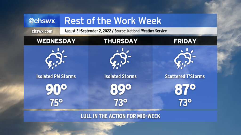
As we head into mid-week and look to round the corner toward Labor Day weekend, we’re going to see a reduction in shower and thunderstorm coverage for a few days as some drier air aloft works in from the north and west. We’ll keep isolated to scattered shower and thunderstorm chances in the forecast as those probabilities won’t be totally eliminated, particularly near the coast, but we shouldn’t see the sustained flooding rains that have been a concern the past couple days. Areas further inland could even see a rain-free couple days, especially on Thursday as a front clears the area and stalls to our south.
As rain chances diminish, temperatures turn back up to a little above normal as we close out August and enter September. Expect highs around 90° for Wednesday; mix in the plentiful humidity and it’ll feel closer to 100-102°. Thursday will run pretty warm, too, with highs around 90° and heat indices in the upper 90s once again expected. Rain chances begin to tick back up on Friday, and that’ll lead to high temperatures topping out a little lower than the previous couple days, generally in the mid-to-upper 80s.
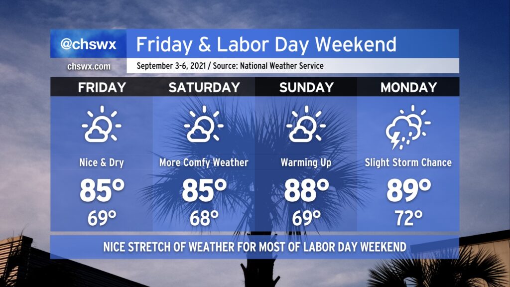
You can likely already feel it in the air — drier air has filtered into the area today, and it feels so much better outside already after a really humid August. A stretch of nice weather will ensue, with temperatures running a little below normal for Friday and Saturday. Lows in the mid-to-upper 60s will feel pretty good, for sure, and we’ll top out in the mid-80s Friday & Saturday. Temperatures moderate a bit higher on Sunday, with dewpoints creeping up as well. Humidity does make a comeback for Monday with a slight chance of afternoon thunderstorms, but all in all, the vast majority of us will stay dry this Labor Day weekend. Hope you can take advantage!