Rest of the work week: A lull in the action brings warm temperatures back
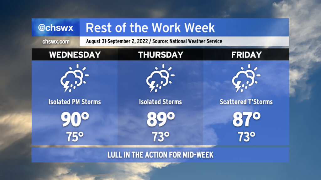
As we head into mid-week and look to round the corner toward Labor Day weekend, we’re going to see a reduction in shower and thunderstorm coverage for a few days as some drier air aloft works in from the north and west. We’ll keep isolated to scattered shower and thunderstorm chances in the forecast as those probabilities won’t be totally eliminated, particularly near the coast, but we shouldn’t see the sustained flooding rains that have been a concern the past couple days. Areas further inland could even see a rain-free couple days, especially on Thursday as a front clears the area and stalls to our south.
As rain chances diminish, temperatures turn back up to a little above normal as we close out August and enter September. Expect highs around 90° for Wednesday; mix in the plentiful humidity and it’ll feel closer to 100-102°. Thursday will run pretty warm, too, with highs around 90° and heat indices in the upper 90s once again expected. Rain chances begin to tick back up on Friday, and that’ll lead to high temperatures topping out a little lower than the previous couple days, generally in the mid-to-upper 80s.
Labor Day weekend: Scattered storms, but no washout
We’ll remain in a semi-unsettled pattern for Labor Day weekend, but a total washout is not expected. Saturday looks to be the most active day as a surface trough helps to instigate scattered to numerous showers and thunderstorms particularly in the afternoon and evening hours. Sunday and Monday look a little quieter, with scattered coverage generally along and ahead of the seabreeze the thinking (at least right now). Temperatures will run around normal — for early September, that’s generally in the mid-80s in the afternoons. Bottom line: Don’t axe any outdoor plans, but have a backup plan ready to go just in case.
Tropical update: A few disturbances, but nothing too concerning
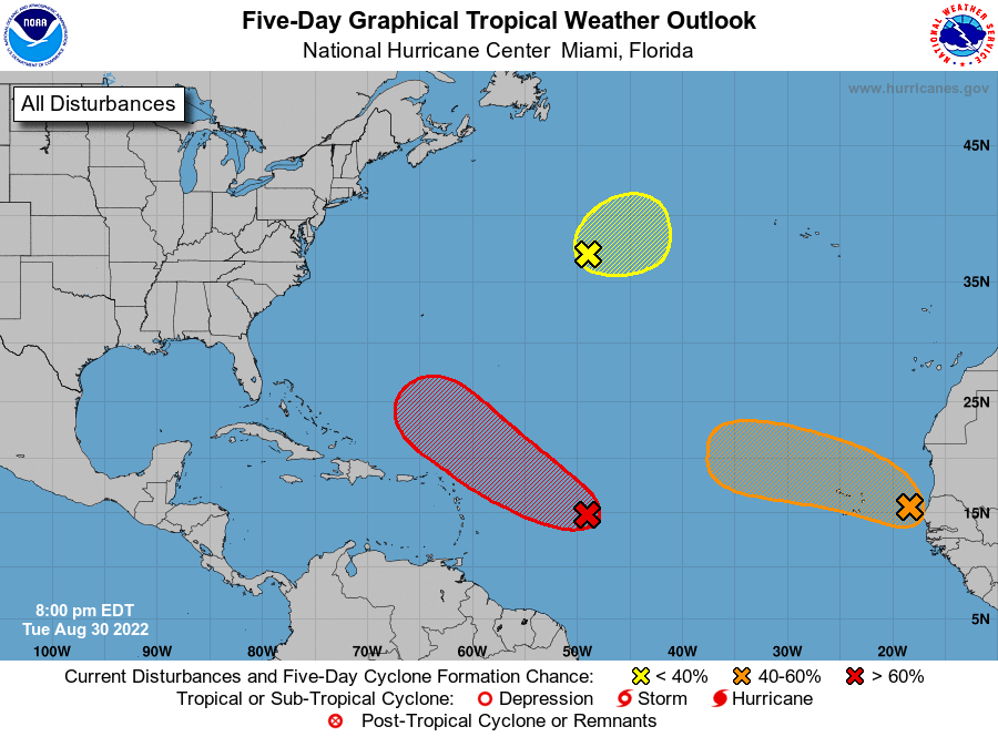
The National Hurricane Center continues to keep an eye on a few disturbances in the Atlantic for possible tropical formation. The closest one, approaching the Lesser Antilles, has an elongated circulation and has been a little more active thunderstorm-wise today, but still has some inhibiting factors (such as dry air) to overcome in order to get its act together. Still, NHC gives this an 80% chance to develop into a tropical cyclone in the next few days. Recurvature away from the US is the probable scenario with this disturbance. If that changes, I’ll let you know.
A second area of disturbed weather coming off Africa has a 40% chance to develop in the next five days. It could be a concern for the Cabo Verde Islands, but should otherwise stay well out to sea. Same with a newly-identified 20% area in the central Atlantic in tonight’s update; this is generally a non-factor as far as we are concerned.
It’s not just you: It has been an unbelievably quiet August in the Atlantic basin, which is made all the more uncanny by the fact that this is a La Niña year! This stat from Dr. Phil Klotzbach of Colorado State University puts that into perspective:
With that in mind, though, there is still plenty of season left. The climatological peak of the season arrives September 10, and the season continues until November 30. We’re no stranger to late-September storms — Hugo, anyone? — and have had our share of brushes in October, too (see Matthew as a very recent example). Let’s hope for continued calm while remaining on guard and prepared just in case a storm does end up threatening us this fall.