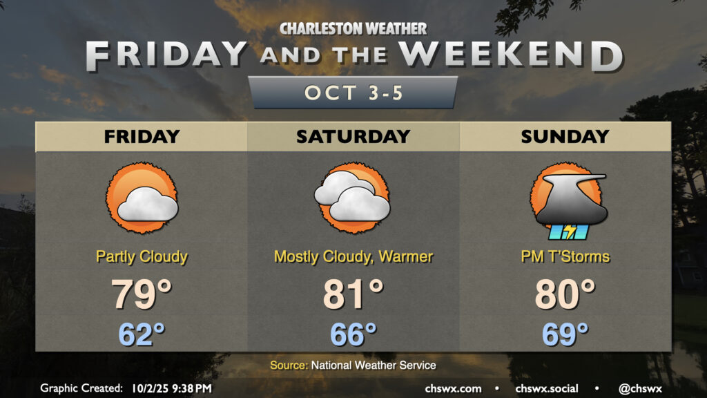
Temperatures will continue to be generally seasonable if not slightly cooler than normal for Friday and the weekend as high pressure continues to wedge southward into the area, though we will see an uptick in moisture and, eventually, rain chances heading into Sunday.
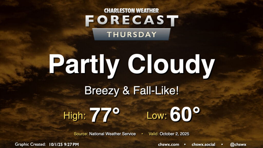
Thursday will give us a really nice taste of fall as cool high pressure wedges southward into the area. We’ll start the day with temperatures around 60°, warming to just the mid-70s under partly cloudy to mostly sunny skies. The northeasterly breeze will still be somewhat elevated, which may contribute to some minor tidal flooding around the 4:45 PM high tide. Otherwise, it’ll be an enjoyable day to get outside and touch some grass.
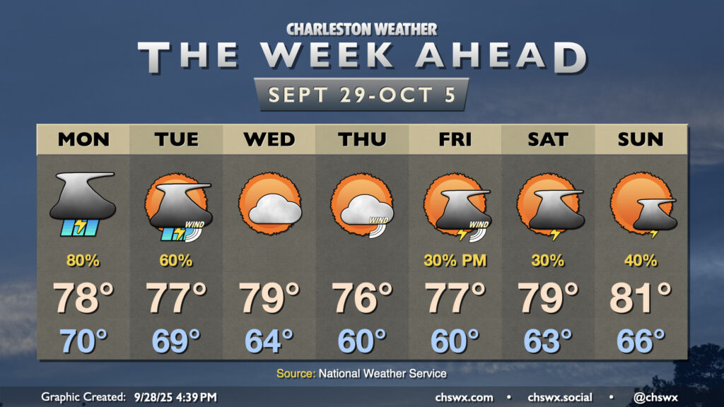
With Imelda departing to our east, high pressure will wedge down across the area, ushering in some cooler and drier air that’ll be particularly noticeable on Thursday. Shower chances return for Friday heading into the weekend, though.
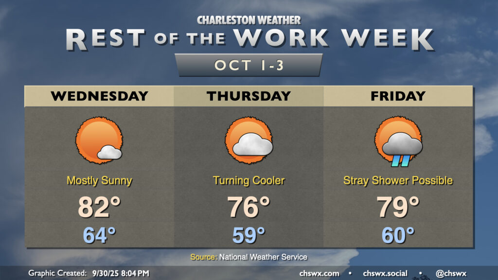
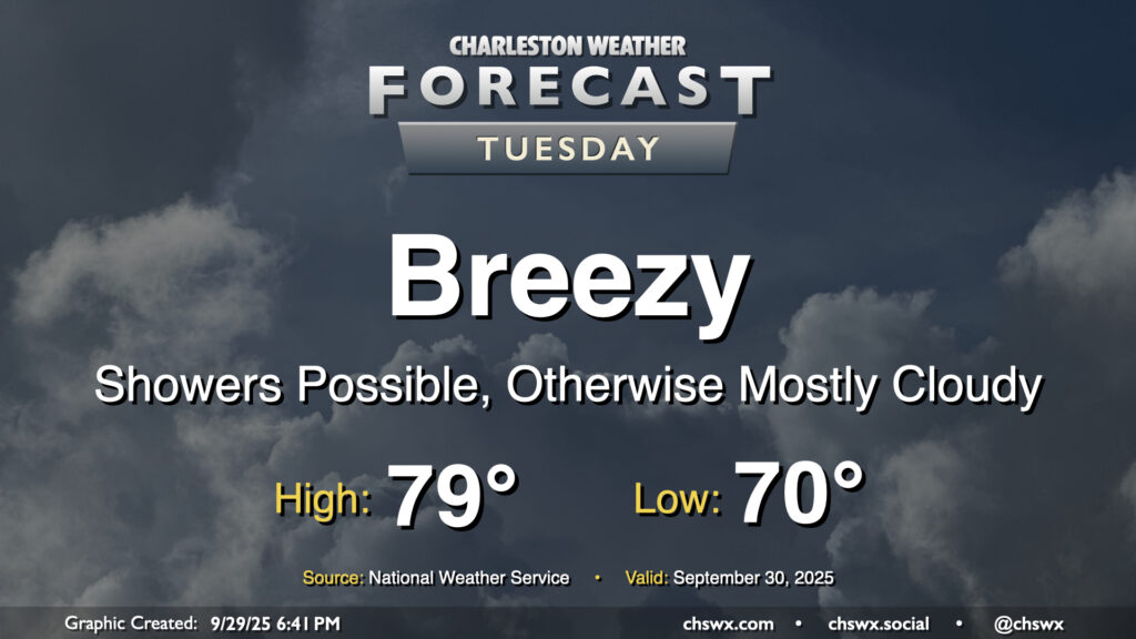
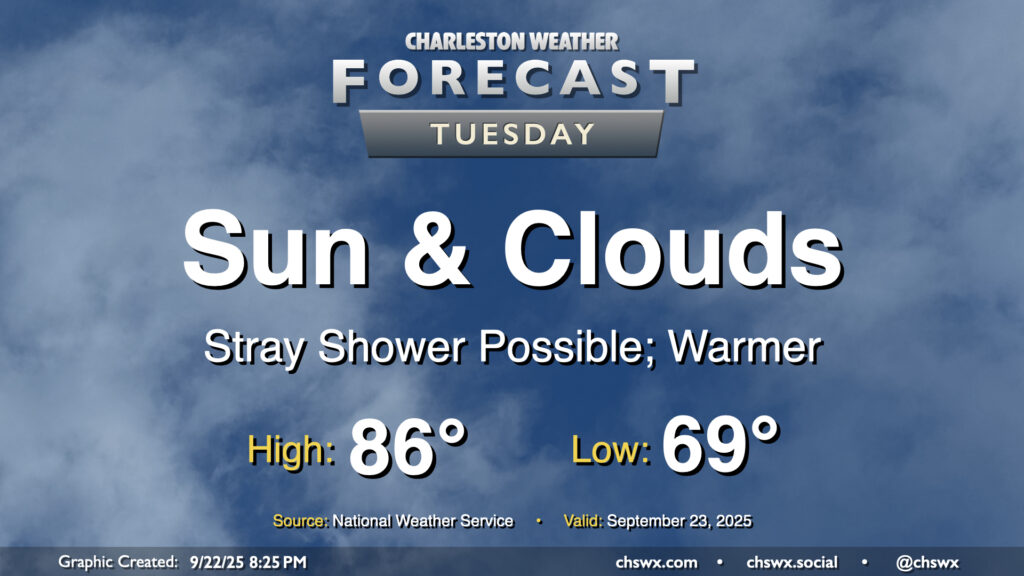
The pressure gradient between high pressure to the north and Imelda to the southeast will be tightening on Tuesday, and we should have a fairly breezy and seasonably cool day once again thanks to those northeast winds as well as cloud cover and a few lingering showers. Temperatures start around 70°, but should only warm to the upper 70s to maybe 80° depending on breaks in the clouds. The decaying coastal front will still be able to contribute to a few showers, but we should see shower chances diminish as we get through Tuesday and Imelda pulls further and further offshore.
There’s a chance that we could see some minor tidal flooding Tuesday afternoon courtesy of elevated water levels due to the onshore, northeasterly flow. The better chances for coastal flooding will begin Wednesday, though, and may be with us for a little bit as we head toward a full moon next week.
We’ll close September on a stormy note as moisture from Tropical Storm Imelda interacts with a stalled front/trough situated along the coast to produce solid shower and thunderstorm chances through Tuesday. From there, a good shot of fall welcomes us to October before more shower and storm chances return for Friday and the weekend.
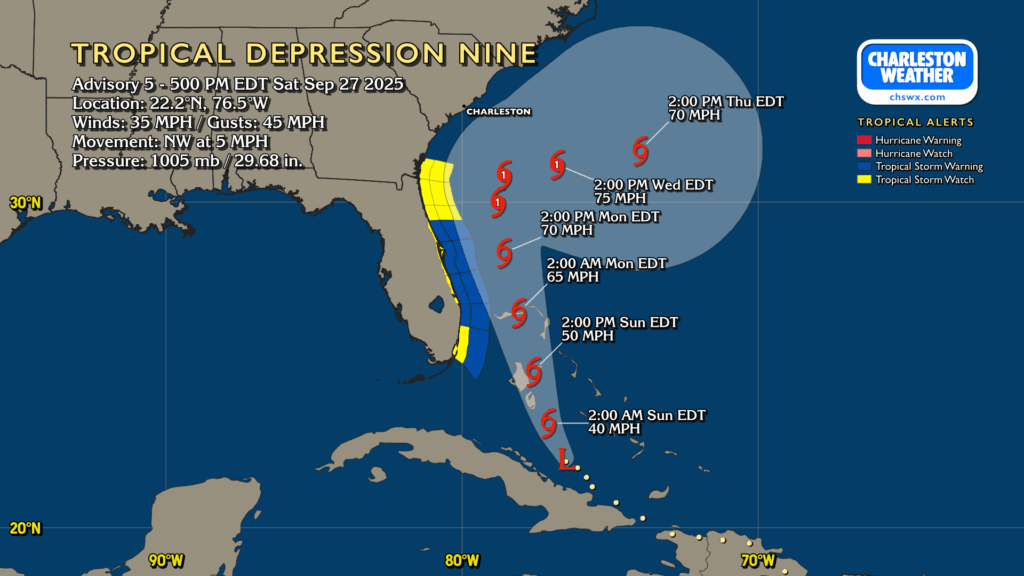
Tropical Depression Nine continues to organize, moving NW at 5 MPH on approach to the Bahamas, where Tropical Storm Warnings are in effect. Nine is still expected to strengthen, becoming a tropical storm tonight or early tomorrow morning. The next name on the list is Imelda.
On the current forecast from the National Hurricane Center, future Imelda will continue to move north-northwest heading into Monday, gradually strengthening into a hurricane (albeit a low-end Category 1). From there, it will stall out somewhere off the GA/SC coast Monday night into Tuesday, meandering until Humberto — a category 5 beast well out in the central Atlantic — gets close enough to help weaken the blocking high pressure to the north and “pulls” presumed Imelda eastward, away from the continental US.
A front and upper-level low will send weather downhill as we get into Friday afternoon and the rest of the weekend, though that won’t be the main weather story, methinks, as we monitor the disturbance currently known as Invest 94L in the tropics for possible development and subsequent impacts next week.
After hitting 91° on Wednesday, we look to take another trip to the 90s on Thursday as ridging aloft combines with Atlantic high pressure to keep us well on the warm side of normal for another day. Temperatures start in the low to mid-70s, well above normal for this point in the year, warming to the 90s in the afternoon with heat indices making it feel more like the mid-90s. We could see a stray shower or thunderstorm in the afternoon and evening along and ahead of the seabreeze, but most of us should stay dry.
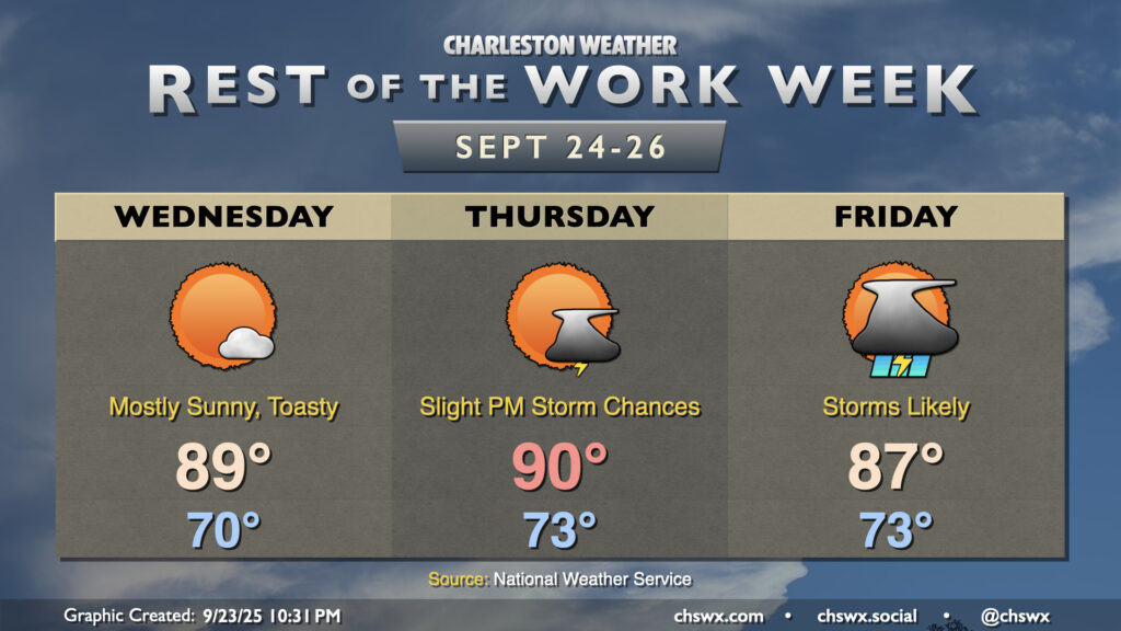
Warmer-than-normal temperatures will persist for the next few days, especially ahead of a cold front that will bring some fairly solid rain chances to the area for the first time in a little while on Friday.
A warming trend begins Tuesday as high pressure to the north continues to weaken and winds turn more onshore, ushering in a much more summer-like feel over the next few days. Temperatures Tuesday start in the upper 60s to around 70°, warming to the mid-80s in the afternoon with a mix of sun and clouds. Factor in the upper 60s-lower 70s dewpoints and it’ll feel more like 90°. Like we saw on Monday, a few afternoon showers are possible, though the weakening high also will portend a weakening coastal trough, which should keep the risk for showers relatively low.