Well, if you’re going to do outside stuff this weekend, Saturday’s probably the day to do it. It’s going to be a gorgeous day — low humidity, plenty of sunshine, and comfortably warm temperatures in the mid-80s after starting out in the upper 50s to low 60s across the metro.
High pressure will slip offshore late Saturday, and dewpoints will climb back into the 70s for Sunday ahead of a cold front. Expect showers and thunderstorms to become somewhat numerous Sunday afternoon into the evening as the front approaches the area. We could see some enhanced rainfall, too, courtesy of a wave of low pressure moving along the front. Temperatures should stay in the low 80s with the expected showers and thunderstorms. Generally, expect .5-1″ of rain across the area, with locally heavier amounts. Severe weather is not expected.
Showers and thunderstorms will be off and on throughout the weekend, particularly Saturday as a disturbance aloft ripples through the area. Winds turning onshore will bring some more moist air into the area, and we could see showers and thunderstorms begin to affect the area by daybreak. Some spots could see some fairly heavy rain at times, and a strong or severe storm isn’t totally out of the realm of possibility (though is rather unlikely). It won’t rain all day, but be ready to enact indoor plans on Saturday if necessary. Highs top out in the mid-to-upper 80s given the cloud cover and rain expected.
Storms should be a little more sparse coverage-wise throughout the day Sunday, though most of us should see at least some rainfall at some point throughout the day. Much like Saturday, the rain risk looks to start at the coast in the morning hours before shifting inland with the seabreeze in the afternoon. Once again, a storm or two could be strong, and some of the rain could be heavy at times, but widespread severe weather just doesn’t seem to be in the equation. Highs on Sunday run a click warmer, but still generally in the upper 80s.
Saturday will be the peak of this stretch of hot weather as temperatures head to the mid-90s in the afternoon (though not quite as high as forecast earlier this week…good thing, too). Heat indices will get close to 109-110° in the afternoon. There’s no heat advisory as of this writing, and if trends continue, we’ll probably fall just short of criteria. Still, these kinds of heat indices still increase the risk for heat illness, so be getting plenty of water if you’re going to be exerting yourself outside in the afternoon. We should see a few storms fire along the seabreeze in the afternoon, which will bring some relief to a few of y’all.
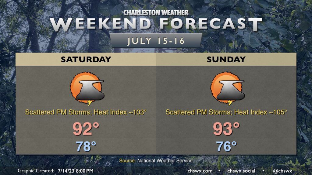
More widespread showers and storms are expected Sunday (though not a complete washout, either) as a front sags southward and stalls out nearby. It’ll be another warm and humid day with air temperatures topping out in the low 90s and heat indices 100-103° before thunderstorms fire off and cool things down somewhat. The unsettled weather will continue into next week as the front hangs around and plays a big role in our weather.
The weather this weekend looks fairly August-like — lows in the mid-70s, highs in the low 90s, with a chance for thunderstorms each afternoon, but no rainouts, either.
Moisture begins to return to the area Saturday as a front approaches and stalls out nearby. The front won’t be a huge contributor to storm chances, it looks like, with the seabreeze doing a bulk of the dirty work in the afternoon and evening hours. The moisture isn’t very deep, though, and that should limit storms to generally isolated to scattered coverage. Highs top out in the low-to-mid-90s; combine this with dewpoints heading into the low 70s, we should see heat indices around 100° for a time.
Trajectories turn more onshore for Sunday, which will act to keep a chance for scattered showers and storms in the forecast for much of the day, progressing inland with time. Widespread coverage isn’t expected, though, and it won’t rain all day at any one location. Highs top out in the low 90s with heat indices around 100-101°.
This might be the last real rain we see for a few days as an expansive ridge builds in across the area for the upcoming work week (and first week of school), which may send heat indices back over 105° across the area for a good chunk of each afternoon. It remains to be seen if heat advisory-level conditions return — stay tuned.
It’s going to be a rather hot weekend in our part of the Lowcountry as high pressure stacks up both at the surface and aloft. This will keep generally drier air aloft in place, but southerly flow at the surface will help keep dewpoints nice and juicy in the mid-70s. Ridging aloft will keep us limited to an isolated storm or two in the afternoons — perhaps a totally rain-free Sunday, even — and so there just won’t be much relief from the heat. Highs will top out in the mid-90s Saturday and the mid-to-upper 90s on Sunday. Heat indices will head between 105-110° on Saturday and could reach or exceed 110° on Sunday, which puts it into post-July 1 heat advisory territory. We won’t get much of a chance to really recover at night, either, as lows bottom out in the mid-70s on Saturday and the upper 70s on Sunday. We will likely not get below 80° this weekend at the beaches and in downtown, either. Suffice to say, if the outdoors are in your plans this weekend, make sure you’ve got access to plenty of hydration and can take breaks in the shade.
Pretty standard early-August fare is in order for the weekend (weather-wise, anyway). Expect to start Saturday in the mid-70s under partly cloudy skies, with highs heading into the low 90s in the afternoon. Isolated to scattered showers and thunderstorms will be possible, though it’s worth noting that Friday afternoon’s high-resolution models keep coverage pretty sparse across the Tri-County. It’s conceivable that some folks may not see a drop of rain — altogether not the worst thing after a fairly wet Friday.
Expect more of the same on Sunday with temperatures heading a couple degrees warmer than Saturday as a nearby front washes out. Heat indices will push 100° in the afternoon with another chance of a few afternoon and evening thunderstorms. Like Saturday, widespread rain is currently not anticipated — just be ready to bring outdoor activities inside in case thunderstorms approach.
Periods of showers and thunderstorms will figure somewhat prominently into Saturday’s forecast as a low pressure system moves across the area. The feed of moisture and shower and thunderstorm coverage should help keep highs from getting into the 90s, though even upper 80s combined with rich mid-70s dewpoints yield heat indices in the upper 90s. The tropical moisture feed could lead to some very heavy rain in some spots, with nuisance flooding possible where the heaviest rains set up. It won’t rain all day in any one location, either, but expect interruptions to outdoor activities.
Sunday should be a little quieter rain-wise (at least to start) as the disturbance lifts away. This will let temperatures head well into the mid-90s, yielding heat indices 105-110°. Scattered showers and thunderstorms should develop in the afternoon and evening hours, and there is a small chance of a thunderstorm complex trying to make inroads into the area later in the evening, so be ready to dodge those if being out Sunday is in your plans. All in all, no washout, but just be flexible.
Air temperatures return to more reasonable levels for mid-July this weekend as a trough digs in a bit more, nudging the ridge that had brought us quite a hot stretch back to the west. It will also improve shower and thunderstorm chances across the area starting Saturday afternoon. Granted, it will still be humid, and heat indices on Saturday in particular will head back north of 100°, but not quite as high as we’ve seen the past few days. Showers and thunderstorms should fire in the afternoon and evening as disturbances round the base of the trough. One or two of these storms could produce strong wind gusts. Be ready for rapidly changing conditions, but don’t cancel any outdoor plans, either.
Sunday could be a little more active as another disturbance passes by. It could instigate scattered storms by midday, but they’ll be more likely in the afternoon. Again, not expecting a washout by any stretch, but be ready to bring outdoor plans inside if thunderstorms approach your location. Highs top out in the low 90s Sunday with heat indices approaching 100°.
A fairly standard mid-July weekend lies ahead across the metro area. Highs top out in the low-to-mid-90s each day after starting out in the mid-to-upper 70s. The seabreeze will be the main instigator for afternoon and evening thunderstorms; as is customary for this point in the year, heavy rain and frequent lightning are the main threats, with gusty winds possible within the strongest storms. Severe or not, all thunderstorms are dangerous due to the lightning they produce. When thunder roars, go indoors.
“Speak Now” (Taylor’s Version) is not the only thing that’s going to get replayed over and over this weekend — so it shall be with the forecast as well. Expect muggy starts in the mid-70s each morning (with temperatures struggling to get below 80° downtown) followed by high temperatures in the mid-90s each afternoon. Heat indices will peak around 105° each day. While that would be a Heat Advisory in June, it happens so frequently in July and August that the criteria is moved to 110° on July 1. So, even though there’s no advisory, the risk for heat stroke is elevated in the afternoons.
From there, scattered showers and thunderstorms will fire along and ahead of the seabreeze as convective temperatures are reached, eliminating the cap that we’ll start the day with. Heavy rain and frequent lightning from slow-moving storms are the main concerns, and these will once again be mostly pulse-type storms (essentially pop up and fizzle out, much like Friday’s storms) with very weak wind shear in place. However, a damaging wind gust or two can never be totally ruled out where outflow boundaries get together and help improve lift, leading to stronger storms.
All in all, don’t expect a washout, but just be ready to move outdoor activities indoors at a moment’s notice. And stay hydrated!