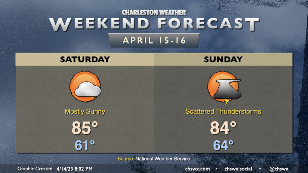
Warm weather continues this weekend, with a break in the rain coming Saturday as we’ll sit in-between storm systems. Highs on Saturday peak in the mid-80s after starting in the low 60s, several degrees above normal for mid-April. If you’re headed to High Water, make sure you’re applying sunscreen as the UV index will peak around 9, in the Very High category.
A cold front will approach the area Sunday, bringing with it the risk for some scattered showers and thunderstorms. Guidance is still somewhat mixed on the exact onset of these storms, but expect the best chance for a few thunderstorms in the afternoon and early evening. There is a small risk for a storm or two to produce damaging straight-line winds and some hail. Remember, though: Lightning makes every thunderstorm dangerous. When thunder roars, go indoors! Outside of storms, expect highs to once again top out in the mid-80s.
The front passes by late Sunday/early Monday, and the cooler and drier airmass behind it will bring us a pretty brilliant stretch of weather for the beginning of the work week. But let’s not think about the new work week yet if we can help it. 🙂
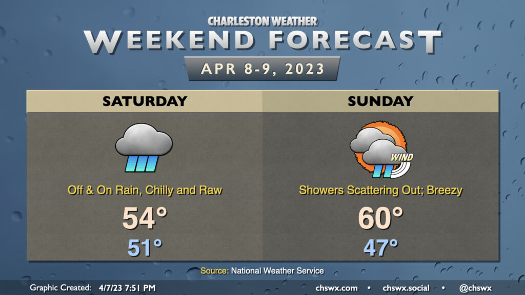
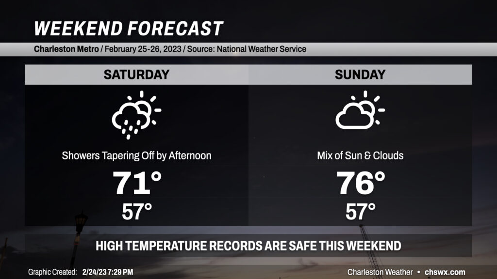
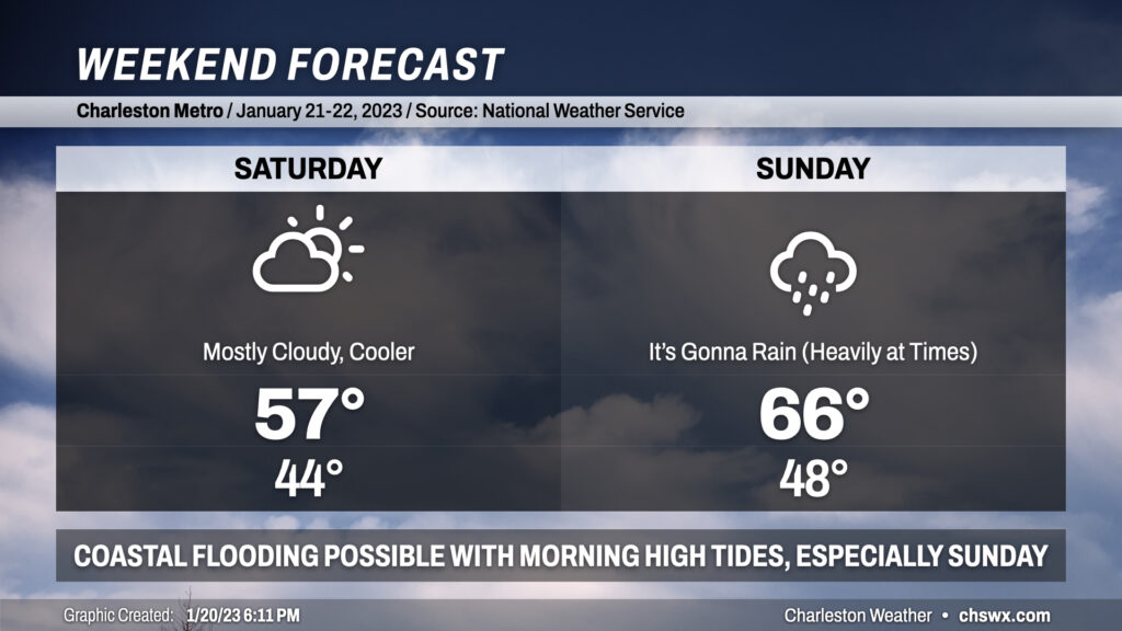
Well, this certainly will not go down as one of the better Easter weekends, weather-wise, as high pressure wedging into the area keeps temperatures well below normal for this point in the year while also keeping showers a prevalent part of the forecast. Don’t count on much, if any, sun on Saturday as scattered showers in the morning and early afternoon turn more steady heading into the later afternoon and evening hours. Temperatures really won’t move much — we’ll start around 51° and only head up to about 54° as a chilly northeast breeze and the rain reinforce the cold air damming regime that’ll be in place.
Showers will continue well into Sunday, but will gradually become a little more scattered as the plume of deeper moisture shunts offshore. The wedge will remain in place, but a somewhat thinner cloud deck and less rainfall should allow temperatures a fighting chance to approach 60° in the afternoon. It’ll be quite breezy — winds will generally run about 20 MPH with higher gusts, especially near the coast. Regardless, you’ll need rain gear for Easter sunrise services.
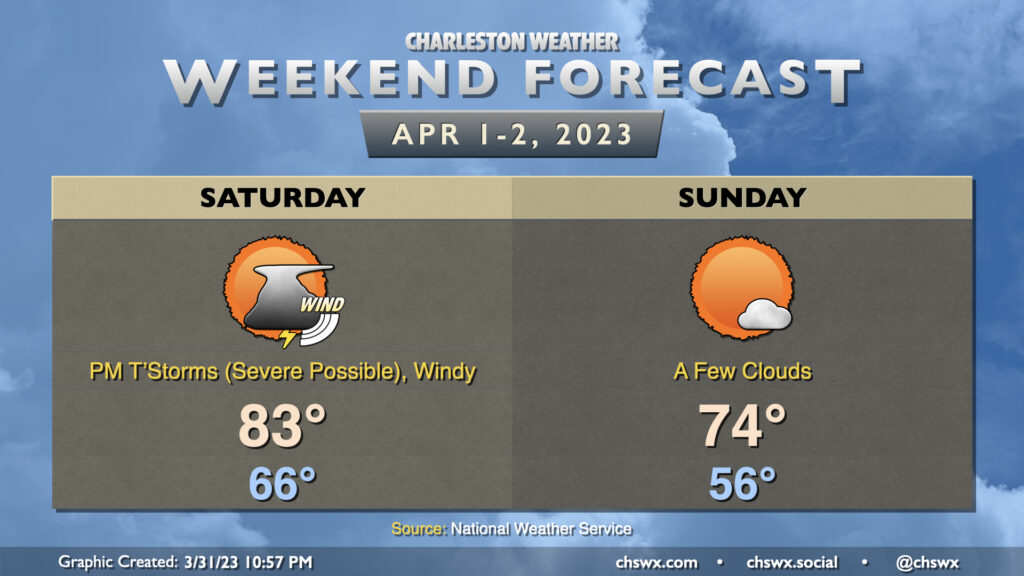
A cold front will be working its way eastward into the metro area throughout the day Saturday, but its associated rainfall will arrive in the late afternoon and early evening, sparing the Bridge Run. It’ll be windy; gusts 30-35 MPH will be possible especially heading into the early afternoon, and this may contribute a bit of a headwind at times during the race. After starting in the mid-60s, temperatures should head into the low 80s in the afternoon ahead of the cold front.
A line of showers and thunderstorms will precede the cold front. It should be losing some steam with the bulk of the energy staying well north, but there is ample wind shear and should be enough instability for a few of these storms to be on the stronger side with wind damage the main concern. Some hail and even a tornado can’t be totally discounted, either, so you’ll want to make sure you have ways to get warnings tomorrow. These look to get into western parts of the Tri-County in the 3-5 PM timeframe, pressing off the coast by 6-7 PM with showers to fall for a little while afterward.
Once the front is through, cooler and drier air works its way into the area. Overall, Sunday should run about 10° cooler than Saturday with a lot more sunshine. It’ll be the pick day of the weekend for outdoor activities with comfortable warmth and low humidity.
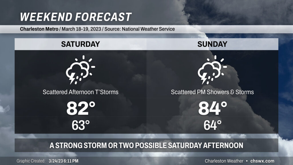
We stay warm this weekend despite a weak front that’ll move in Saturday and stall out across the area. Highs each afternoon will peak in the low to mid-80s, with lows solidly in the low-to-mid-60s.
The aforementioned front will be the focal point for increasingly unsettled weather. As the front approaches Saturday, scattered showers and thunderstorms — a couple of which may be on the strong side — will be possible primarily in the afternoon through early evening. Outside of thunderstorms, winds will be gusty at times, with gusts approaching 30 MPH especially on higher bridges.
Sunday starts on a dry note, but as the afternoon progresses, the lingering front will act as a focal point for developing additional showers and maybe a few thunderstorms. Rain chances will last well into Monday and Tuesday before the front is shoved out of here by high pressure. Still, expect highs to climb into the mid-80s.
Bottom line for this weekend: No total washout expected, but you’ll want to keep an eye to the sky if you’re outdoors.
First off: If you’re heading out tonight, expect the rain to stay away from Charleston proper until around midnight. It may begin to rain earlier the further inland you are, though, so keep rain gear handy just in case.
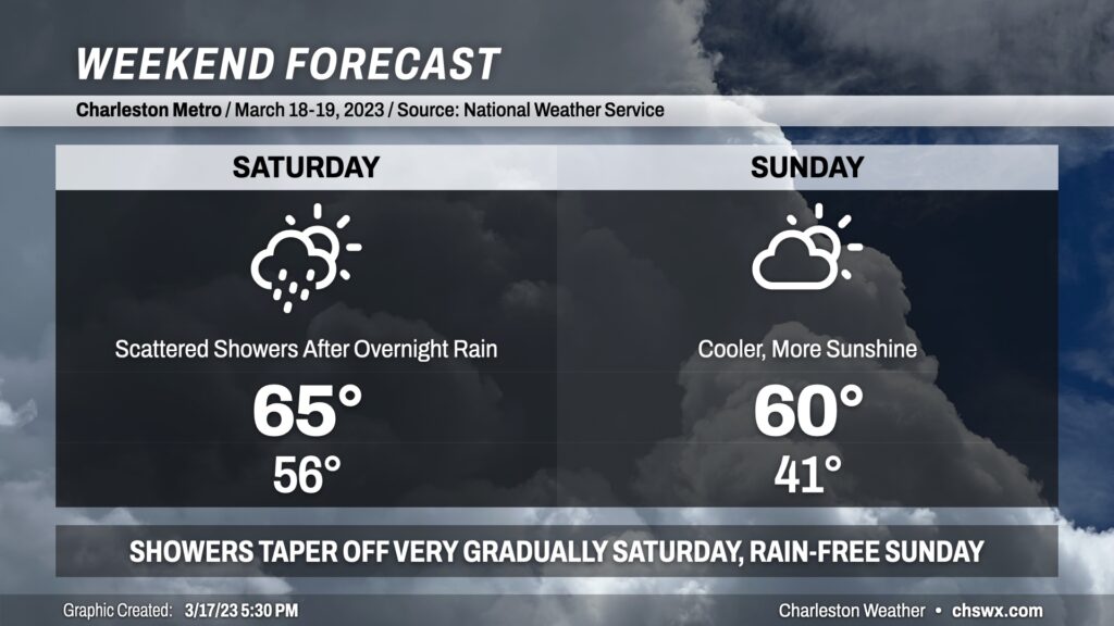
A cold front will come through the area early Saturday, putting an end to the brief warmup that closed out the work week. Lows will run in the mid-50s, but highs will only top out in the low to mid-60s in the afternoon. The bulk of the rain falls overnight, but scattered showers — and perhaps an embedded downpour or two — will remain possible through mid-afternoon, it looks like. A shower may not be completely out of the picture into the evening hours. With that in mind, I don’t see tomorrow as a total rainout — suspect most of us will get a fair bit of rain-free time in.
Sunday will be much cooler as high pressure continues to build in from the west. Despite more sunshine, highs will struggle to 60° as cool air continues to blow into the area from the north, with wind speeds generally around 5-10 MPH.
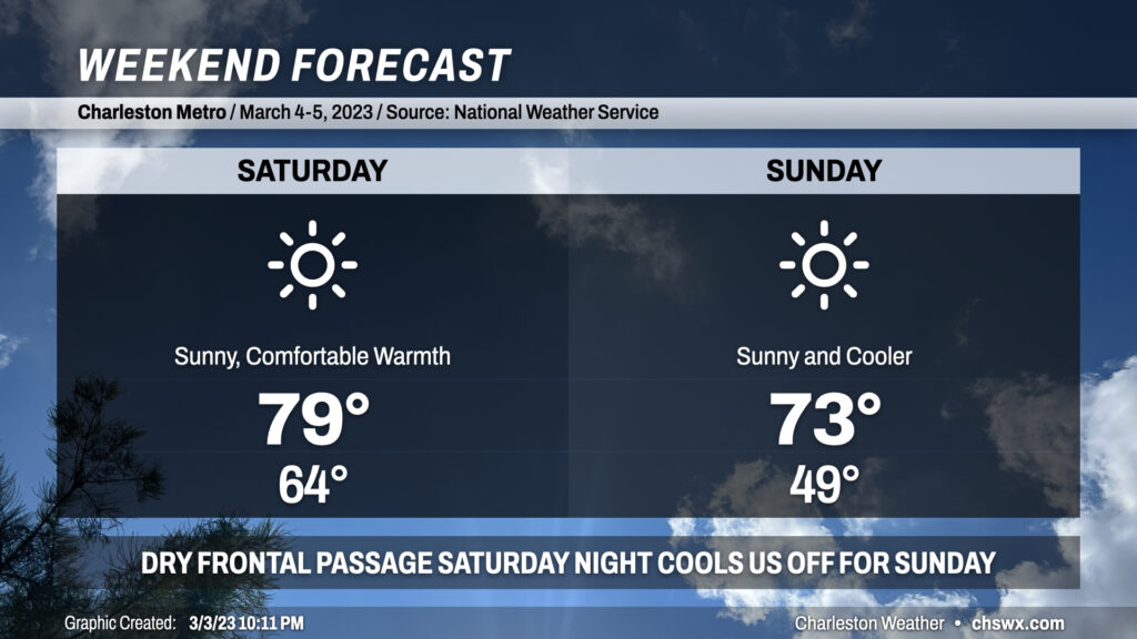
If it weren’t for the pollen, I’d unequivocally endorse this weekend as a great one to get out and about. Once a cold front and its associated thin line of showers clears the area overnight, skies will clear and give us a brilliant couple days. We start Saturday in the mid-60s as some of the slightly cooler and drier air lags a bit, but we’ll see dewpoints mix out nicely as the day goes on, allowing for a comfortably warm day as temperatures approach 80° but with less humidity than the past few days.
A secondary cold front will come through overnight Saturday into early Sunday morning. It will be starved of moisture, so a dry passage is expected. The airmass behind this front is more noticeably cooler and drier. You’ll certainly feel the difference when we start Sunday around 50° — the coolest start to a day since the temperature bottomed out at 48° on February 20 — and only see temperatures rise into the low-to-mid 70s in the afternoon despite pristine skies. We’ll see some occasionally breezy conditions both days, but other than that, really nice weather is in store with a little more seasonable feel on the way.
Our recent string of record warmth, punctuated by a high of 86° today that breaks last year’s record of 84°, takes a pause this weekend as a backdoor cold front stalls out near the area. Showers filling in tonight will peak overnight as low pressure develops along the coast. As this low pressure pulls away during the day Saturday, so will the chance for rain. Bottom line for precipitation: Keep rain gear handy, but you may not end up needing it. Cloud cover and high pressure wedging in from the north will keep temperatures well below where they have been recently, but still above normal, peaking in the low 70s.
Said front lifts back north of the area on Sunday, bringing in a little more in the way of sunshine and warming temperatures back into the mid-70s. This is roughly 10° above normal for this point in the year, but the record books will remain intact as the record high of 83° set in 1996 looks to remain safe. By Monday, we should be back into the 80s as ridging re-establishes itself aloft.
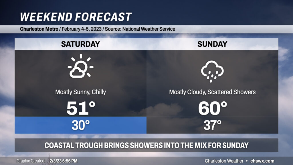
We get off to a very chilly start on Saturday, with many of us dipping into the upper 20s to around 30° in the morning under clear skies. Northeast winds around 10 mph or so will make it feel closer to the low 20s, so you’ll definitely want those layers if you’ve got plans Saturday morning. Despite full sunshine, highs will only top out around 50° given the very chilly airmass in place.
The really chilly weather will not stick around, though. Clouds will start to increase overnight Saturday into Sunday as high pressure slips offshore and a coastal trough sharpens. This trough could trigger some scattered showers for a decent bit of the day on Sunday, though it won’t rain all day in any one location, and showers should come to an end by evening. Temperatures on Sunday will bottom out in the mid-to-upper 30s before warming into the low 60s in the afternoon as some warmer maritime air makes it ashore.
From there, we’ll be back into a warming trend with 70s possible by Wednesday, and our next shower chances look to arrive later Thursday into Friday.
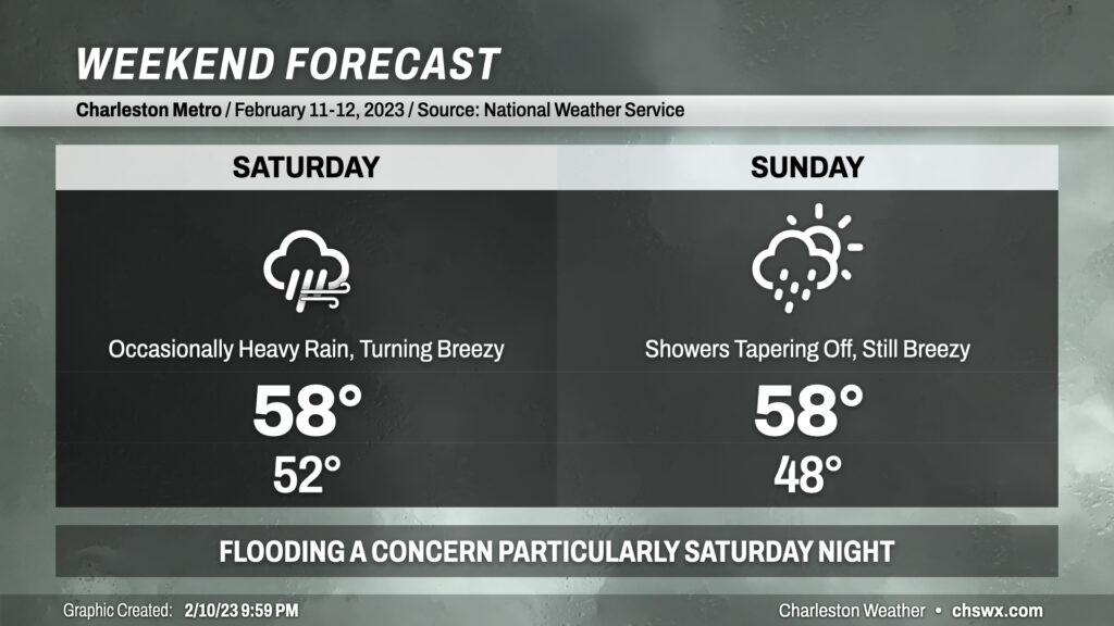
Despite thickening cloud cover and a cool wedge of high pressure building in Saturday, it’ll be the day to do anything outside as Sunday looks more active with some heavy rain at times and maybe some coastal flooding in the morning to boot.