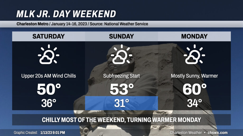
The weather turns quieter but much cooler this weekend as we get the first real taste of January weather almost mid-way through the month. After showers depart overnight, clouds will break up and temperatures will bottom out generally in the mid-30s; northwest winds 10-15 MPH will make it feel closer to the upper 20s. Despite clearing skies, the high will struggle to about 50° on Saturday with breezy northwest winds ongoing.
Winds slacken some, but not completely, Saturday evening into Sunday. We should see freezing temperatures in the metro for at least a few hours Sunday morning as lows drop to around 30-31°. The continued cool advection from the northwest will help bring these colder temperatures to the coast, though we should stay just above freezing there. This isn’t a December 2022 freeze by any stretch, but be sure to have your pets inside and loved ones accounted for. A little ridging begins to nose in aloft, which will allow highs to head a little more north of 50° than we will see on Saturday.
Monday will start in the mid-30s once again, with calm to light winds expected, taking the bite off the wind chill. Continued mostly sunny skies will allow the high to reach up around 60°, making for fairly nice conditions for outdoors Martin Luther King, Jr. commemorations.
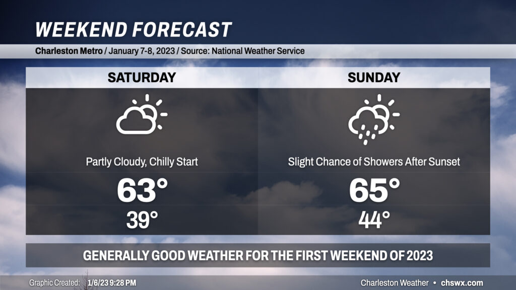
The first weekend of 2023 is here, and the weather overall looks pretty good across the area, particularly Saturday. Morning cloud cover and lows in the upper 30s will give way to more sunshine and highs in the low-to-mid-60s, still above normal for this point in the year. Sunday will feature more in the way of cloud cover throughout the day as some energy aloft approaches from the west. Despite the cloud cover, expect highs to still reach into the mid-60s in the afternoon. The aforementioned energy could lead toward some isolated to scattered showers breaking out after sunset Sunday into early Monday. Significant rainfall is not expected, though. All in all, not a bad weekend to get out and about!
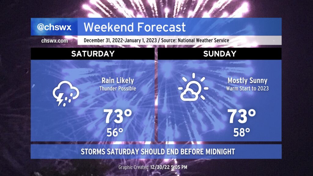
2022 will come to an unsettled end across the Lowcountry as showers and perhaps a few thunderstorms develop and move through ahead of a cold front. A stronger storm or two will be possible near I-95, but otherwise expect generally off and on showers. The best risk for showers will occur in the afternoon through the early evening hours; yes, it is conceivable we may have the precipitation out of here as the clock strikes midnight. It will certainly be mild, with highs in the low 70s. Temperatures will run in the upper 50s as 2023 begins, so it should be fairly comfy with a light jacket.
The atmosphere will be drying out during the day Sunday, with cloud cover decreasing and some drier air moving in. It’ll still be warm, though, thanks to high pressure ridging aloft: once again, expect highs in the low to mid-70s. Overall, not a bad start to 2023!
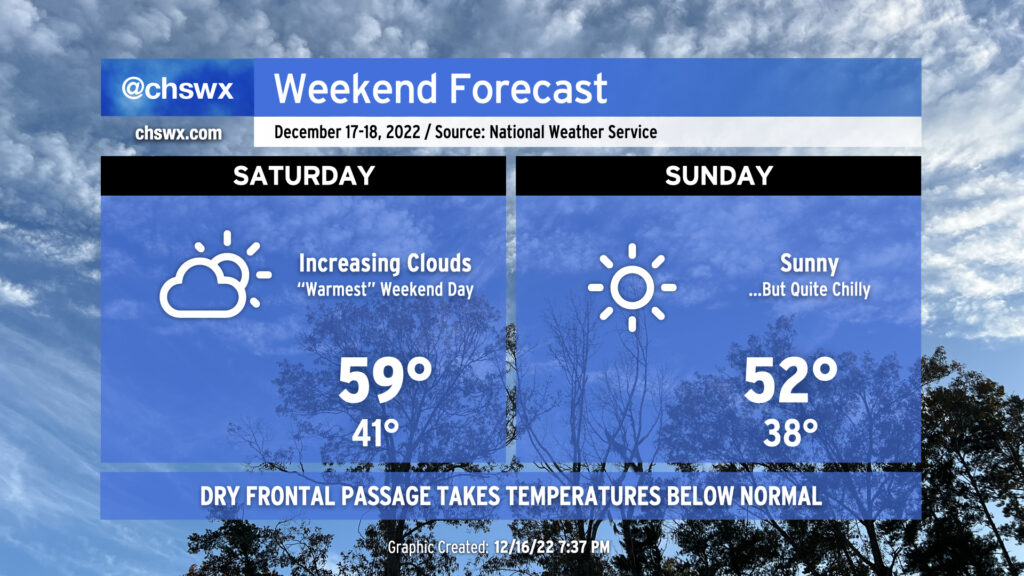
Not too much to write home about in the weather department this weekend except make sure you’ve got your hoodies and sweaters freshened up and ready to go. Saturday will be the “warmest” day of the weekend, with highs topping out around 60° after lows in the low 40s start the day. (West winds around 5 MPH will make it feel like the upper 30s.) Clouds will be on the increase as a relatively moisture-starved cold front approaches the area during the day.
Said front will pass through overnight, which will scour out cloud cover in time for Sunday. Temperatures will start a few degrees cooler — generally in the upper 30s with wind chills in the mid-30s — Sunday morning, but cold air advecting in from the northwest will keep high temperatures in the low 50s despite full sunshine.
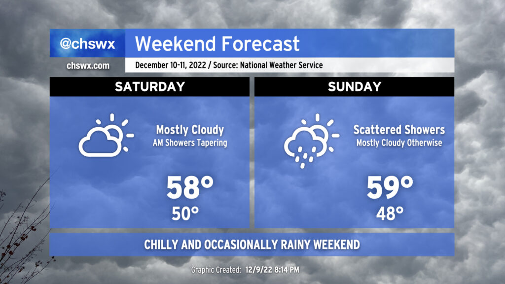
Cold air damming will be the main weather driver this weekend as high pressure wedging in from the north will keep us chilly and mostly cloudy.
Saturday will be the more rain-free of the two weekend days as a little drier air aloft punches in between upper-level disturbances. Lingering showers shut off around daybreak, and we could see some breaks in the cloud cover from time to time, but overall, mostly cloudy skies will be the rule as temperatures struggle into the upper 50s.
Expect similar conditions for Sunday as the wedge continues to hang on. Rain chances return by Sunday afternoon/early evening as the next disturbance moves atop the area. Temperatures will once again struggle to the upper 50s with the wedge in place, so the fleece-lined rain gear might feel pretty good.
Naturally, the weather will begin to improve on Monday…c’est la vie. But for now, it’s a good weekend to enjoy some good soup and maybe catch up on some TV or reading.
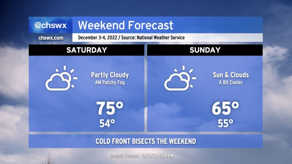
Expect generally quiet weather this weekend despite a cold front sinking southward halfway through. Saturday will start much warmer than Friday did, with lows in the mid-50s as opposed to the upper 30s. Watch out for some patches of fog to develop in the morning potentially having brief impacts on visibility. Any fog that develops will scour out shortly after sunrise, yielding partly cloudy skies for the balance of the day. Highs will top out in the mid-70s, generally about 5° warmer than Friday despite some additional cloud cover. There’s an outside shot of a few sprinkles later in the day on Saturday as the front gets closer, but the vast majority of us should remain rain-free with measurable rainfall not expected.
The aforementioned frontal zone passes through the area overnight Saturday and stalls out to our south. We’ll see an uptick in cloud cover (though some sun should still break through) with highs likely struggling a bit to the mid-60s at best. (This evening’s guidance suggests even cooler high temperatures are possible, so stay tuned for revisions.) We should remain generally rain-free, though I wouldn’t be shocked to see sprinkles get introduced into the forecast if some of the colder solutions with a stronger high pressure wedge verify.
All in all, though, it won’t be too bad of a weekend. Warm weather fans will enjoy Saturday, while the sweater-inclined amongst us will likely prefer Sunday. So it goes in December as the seasons continue their tug-of-war.
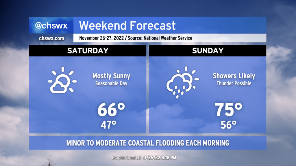
We get a good break from the gray skies on Saturday as we find ourselves between storm systems. The lull will bring us a nice, seasonable day, with lows in the mid-40s followed by highs in the mid-to-upper 60s, right in the ballpark for where we should be at this point in the year. The only fly in the ointment will be the risk for minor to moderate salt water flooding around the 9:29am high tide.
Clouds build back up Saturday evening as the next storm system makes its approach to give us another round of rain for Sunday. A warm front will lift north across the area throughout the day, allowing temperatures to top out in the mid-70s despite showers and maybe a thunderstorm or two in the area. The best chance for rain will be in the morning through the early afternoon hours. Expect the front to get through by evening, which will shut off the rain and dry out the air. Winds will be a little breezy with sustained winds approaching 20 MPH with higher gusts.
Sunday will mark the end of this king tide cycle, with minor flooding possible with the 10:28am high tide. A few downpours will be possible with the storm system moving by on Sunday, and we’ll want to watch for any to coincide with the mid-morning high tide.
Improving weather returns to start the new work week; the next shower chance will be mid-week, followed by seasonable temperatures to start December.
We have another chilly night in store across the metro area, as another round of frosty conditions may be possible tomorrow morning with temperatures reaching freezing in a few more sheltered and rural areas. Once again, bring pets and plants in to keep them safe from the cold.
We’ll see increasing cloud cover on Saturday as high and mid-level clouds filter into the area, but we should remain rain-free as temperatures struggle to 60° in the afternoon (we reached 59° on Friday with full sunshine, FWIW). A front will get by Saturday night into early Sunday; while we’ll start Sunday in the mid-40s — roughly 11° higher than forecast for Saturday morning — highs will once again struggle back to the mid-50s with cloud cover and cool advection ongoing.
Aside from maybe a sprinkle or two Saturday evening, the weekend looks rain-free. We keep this rain-free weather going until late Tuesday into early Wednesday, with a slight shower chance on Thanksgiving. Temperatures next week will warm back into the low-to-mid-60s, still a few clicks below normal for this point in the year.
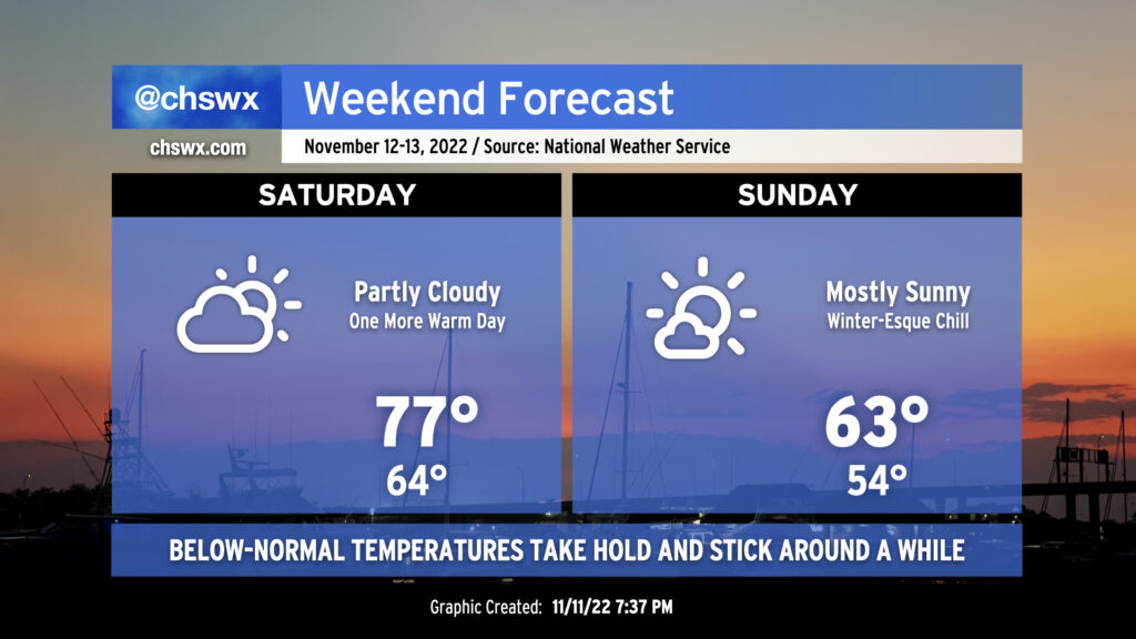
It’s a tale of two air masses this weekend: The warm, still somewhat humid Saturday giving way to the winter-like, much cooler and drier day on Sunday. Nicole’s legacy will hang around one more day in the form of the somewhat modified tropical airmass; while dewpoints will be lower than they have been the past couple days, mid-60s dews are still pretty moist for this time of the year. We’ll see a mix of sun and clouds ahead of a cold front — oh, the cold front — that will pass by rain-free on Saturday night.
Sunday’s going to be a completely different animal as cold Canadian air rushes into the area. Lows will bottom out in the mid-50s on Sunday, but despite nearly full sunshine, the cold air advecting in will keep highs only in the low 60s. Sunday night into Monday will be a much different story, with lows potentially dipping into the upper 30s in spots — will need to keep an eye out on frost potential for Monday morning.
Next rain chance arrives with a reinforcing shot of cold air on Tuesday into Wednesday; we’ll close next week unable to get temperatures above 60°, it looks like. Bottom line: Sweater weather fans, time to shine!
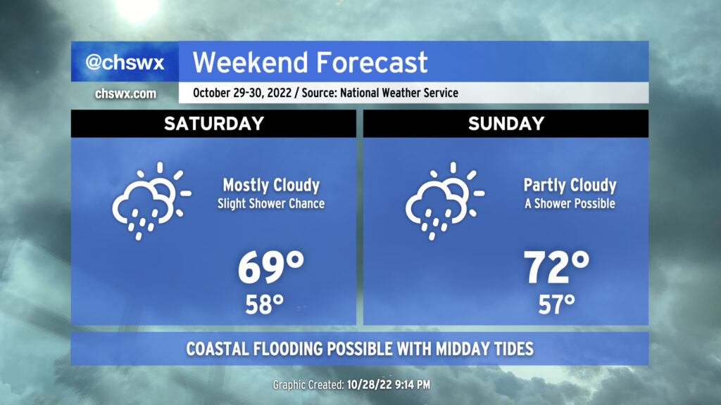
The weekend forecast will generally run on the cool side, particularly on Saturday, with a few showers possible at times. High pressure remains wedged into the area, and moisture trapped beneath the wedge inversion aloft will keep cloud cover and a few light showers in the forecast. Much like Friday, highs will likely not exceed 70° with the lack of insolation and cool northeasterly winds continuing to reinforce the wedge.
We should see a little bit more sunshine — and a little more warmth as a result — on Sunday as the wedge begins to erode. Still, a few showers will be possible at times, and one should not 100% trust the wedge to erode when it is supposed to.
Overall, you’ll want to have a hoodie or light jacket both days, and be ready to evade a few light showers, but it won’t be enough to cause major problems.