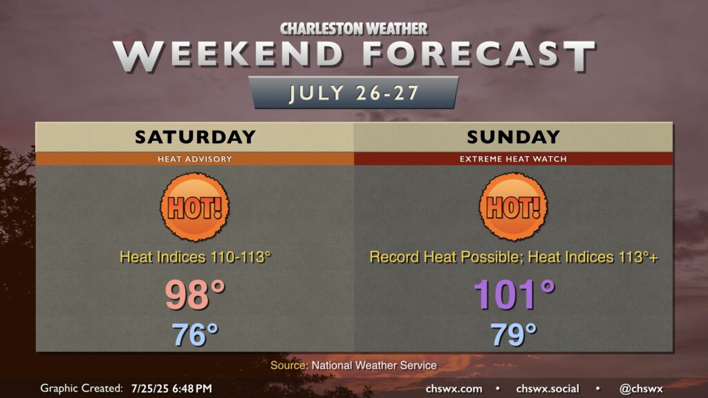
This is one of those weekends where you probably want to just stay in a nice, cool place as a heat wave begins to ramp up across the Lowcountry, with the potential for several record highs and record warm low temperatures to occur starting Saturday through much of next week.
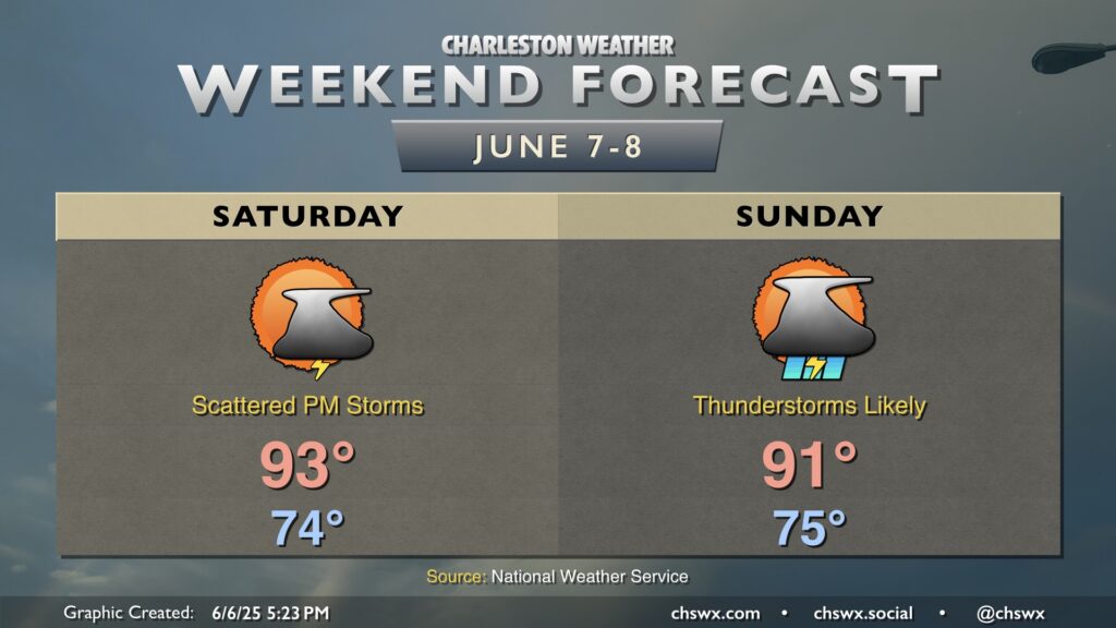
We’ve got a rather hot weekend ahead as high pressure builds in overhead and at the surface. We can expect temperatures each day to head into the upper 90s each afternoon, with heat indices surging to around 110° in spots especially in the immediate wake of the seabreeze.
Plenty of heat and humidity continues as we head into the weekend, and this will lead to more afternoon thunderstorms (though perhaps not quite as many, especially Sunday). A ridge of high pressure aloft will nudge into the area from the west — enough to keep the heat on, but not quite enough to totally squelch the afternoon thunderstorm threat either. Temperatures will run in the mid-to-upper 70s each morning, warming to the low-to-mid-90s each afternoon. Showers and thunderstorms will initiate on the seabreeze as it pushes inland, though the prevailing flow around the ridge could send some storms back coastward — something to think about if the beach is in your plans. The ridge nudges in a bit more for Sunday, and that should help to keep the risk for thunderstorms a little lower than on Saturday, but either way, just be prepared to bring your outdoor activities indoors if thunderstorms approach.
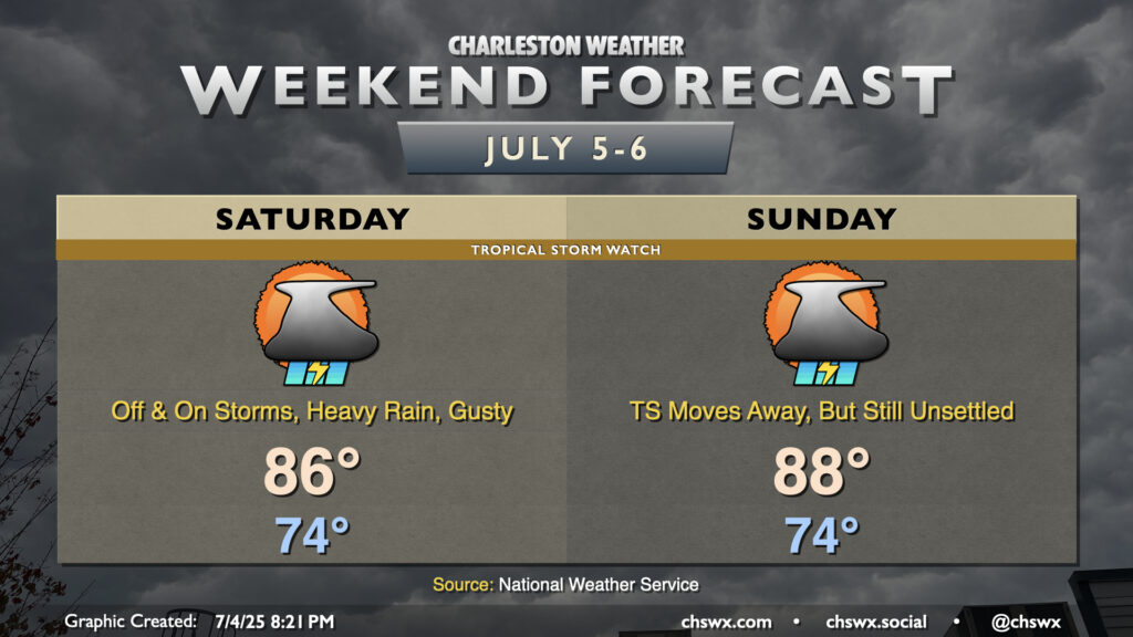
Tropical Depression Three developed this afternoon off the Southeast coast, and will be the main driver of our weather this weekend. Even though Three is forecast to become Tropical Storm Chantal, this should largely be a beneficial system, bringing some rain to some parched spots. However, it will still bring a few hazards, including gusty winds (40-45 MPH) near the coast and offshore, a high risk of rip currents, and the potential for locally heavy rain that could lead to some flooding, particularly around the afternoon high tide. This potential has prompted a Tropical Storm Watch for Charleston County. With all that said, though, this is nothing we can’t handle.
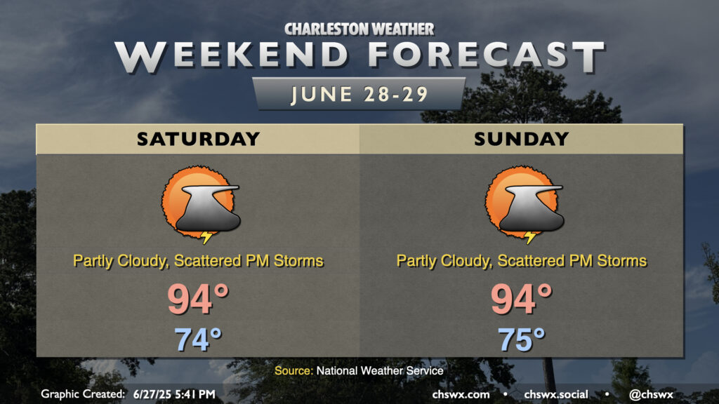
The final weekend of June will have that classic end-of-June feel: lows in the mid-70s, highs in the mid-90s, and isolated to scattered afternoon thunderstorms each day.
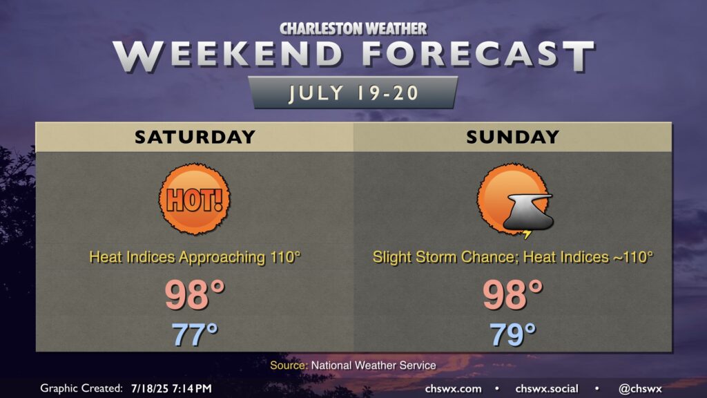
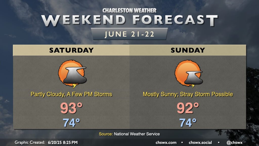
Summer heat will continue this weekend with limited chances for a few storms to cool things off. Saturday will start in the mid-70s, warming to the low-to-mid-90s in the afternoon. Mix in dewpoints in the low 70s, and it’ll feel more like the mid-to-upper 90s. There will be a bit more moisture available Saturday, which could allow for slightly greater storm coverage as the seabreeze pushes inland during the afternoon. However, most of us shouldn’t count on a storm to cool things off. Any storms that fire will dissipate with the loss of daytime heating.
A stray storm or two will be possible Sunday, but the vast majority of us should stay rain-free as dewpoints once again mix down to the low 70s in the afternoon owing to a lot of dry air aloft. We’ll warm to the low 90s, but the lower dewpoints keep heat indices relatively in check, only running a few degrees above the air temperature. That’s not to say that feeling like the mid-90s is in any way “cool” though!
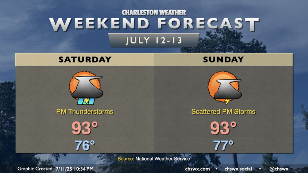
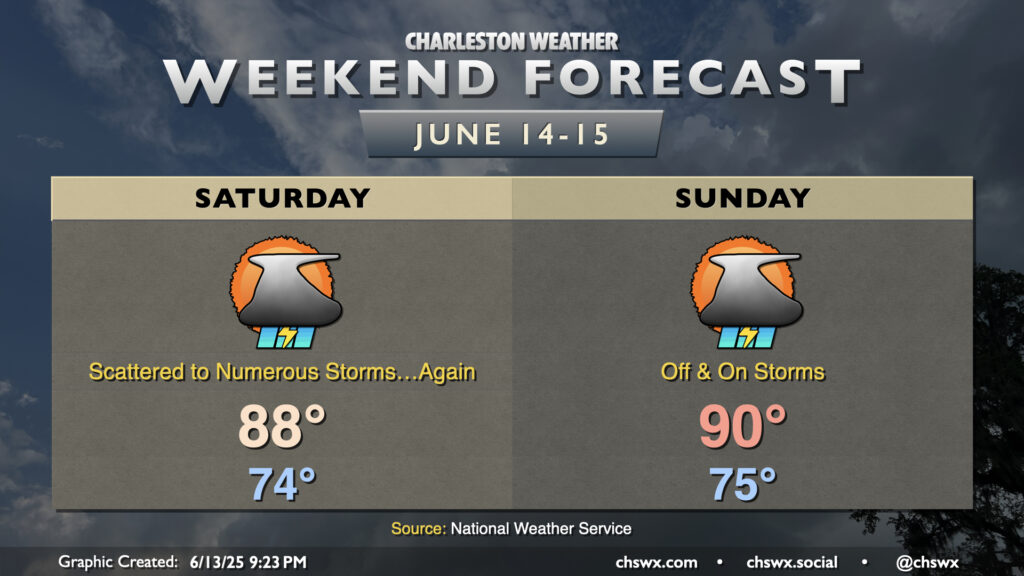
I’m running out of ways to say “it’s going to be hot and stormy” but here we are. The pattern remains stagnant with the Charleston area on the western periphery of Atlantic high pressure at the surface and aloft. Mid-level disturbances will continue to ripple into the area from the west, and those disturbances combined with a continued influx of warm and humid air will keep rain chances elevated, especially in the afternoons. Saturday starts in the mid-70s, warming to the upper 80s in the afternoon. Thunderstorms should initiate once again in the late morning and early afternoon hours, particularly along and ahead of the seabreeze. As with previous days, the risk for severe weather is generally low, though a strong to severe storm can’t be ruled out especially where outflow boundaries collide.
We’ll do it again on Father’s Day, with lows in the mid-70s warming to around 90° in the afternoon. Once again, expect scattered to numerous showers and thunderstorms to develop across the area especially during the afternoon hours. Once again, pockets of heavy rain will be possible, and an isolated severe storm is not out of the question. As always, though, all thunderstorms are dangerous due to the lightning they produce. Remember the rule: if you can see lightning or hear thunder, you are close enough to be struck and should head inside.
Heat and humidity will continue to feature prominently in the weekend’s weather as we watch disturbances to our west potentially introduce a risk for strong to severe thunderstorms at times. If you have outdoor activities planned this weekend, keep a close eye on the weather.
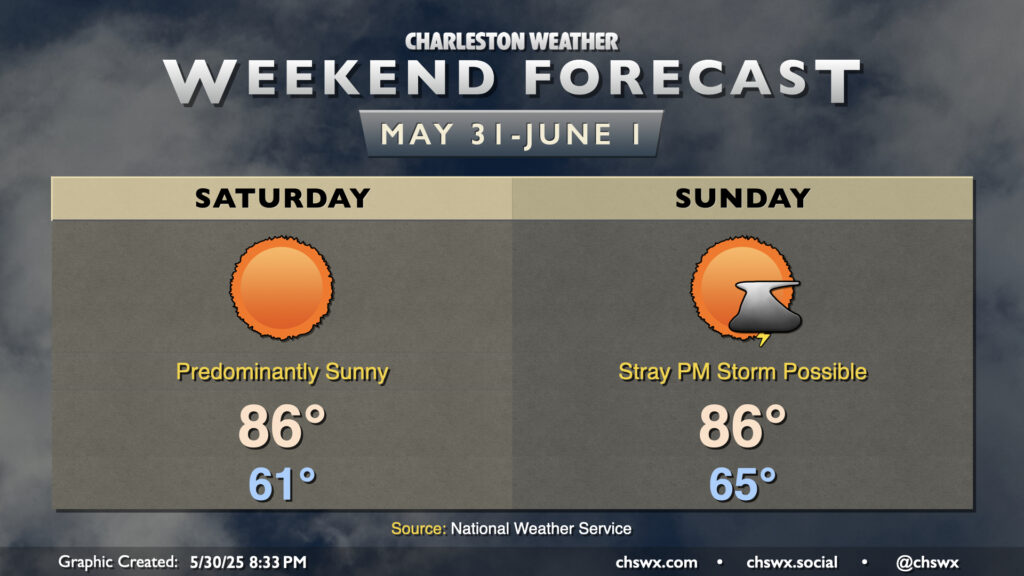
A welcome respite from the humidity and constant threat of storms arrives in the wake of a cold front on Saturday. It’ll be noticeably cooler in the morning, with lows bottoming out in the low 60s with the cooler and drier air setting into place. Temperatures warm nicely to the mid-80s in the afternoon, and humidity will be on the low side for the end of May, which is a nice cherry on top.
A stalling front and some energy aloft could stir up a few thunderstorms Sunday afternoon, but otherwise it should still be a decent day of weather outside of those storms as dewpoints mix down to the upper 50s in the afternoon. You’ll want to keep an eye out for popups as you embark on your outdoor activities, but many of us should be rain-free for much of the day.