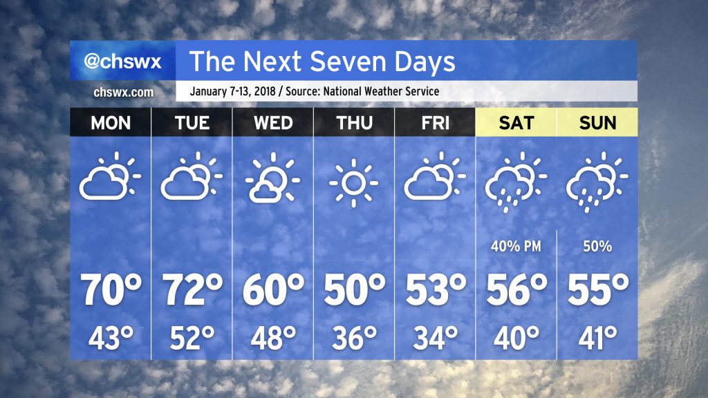
The week ahead: January 7-13
I hope everybody enjoyed this absolutely fantastic weekend of weather. Our stretch of dry weather should continue through the rest of the work week before unsettled conditions return to the forecast for the weekend.
Warm, then a reinforcing shot of cool air to close the work week
We’ll start the work week with temperatures well above normal — think highs in the low 70s when it should be closer to 59°. Clouds will be on the increase Monday and Tuesday as a weak coastal trough develops nearby. Right now, thinking is that conditions stay dry, though I won’t rule out a shower or two near the coast late Monday into Tuesday.
A cold front will come through overnight Tuesday into Wednesday with an enhancement in cloud cover and likely little else. This will send temperatures sharply cooler as we close out the work week, with a shot at temperatures at or around freezing on Friday morning.
A couple notes on January’s warmth
We’ve had 25 straight days of above-freezing temperatures at the airport, dating back to December 13, 2018. This looks to continue for at least a few more days. If it continues beyond January 13, it’d be the first time since 2005 that we had made it almost two weeks into January without temperatures reaching freezing.
In case you’re wondering, there are only two Januarys on record that are devoid of freezing temperatures: January 1974 and January 1989. The first freezing reading of 1974 came on February 5, and the first such reading in 1989 came on February 9.
Unsettled weather returns for the weekend

After a dry conclusion to the work week, unsettled weather will return to the picture for the weekend. (How December 2018 of it.)
High pressure to our north will move east into New England. This will cause it to “wedge” down the East Coast into SC and GA, establishing a cold air damming regime that will keep highs from getting too much out of the mid-50s. At the same time, a low pressure system will take shape along the Gulf Coast and move eastward. Increasing moisture atop the wedge and the approach of the low will thicken cloud cover and lead to scattered showers on Saturday, with coverage increasing overnight Saturday into Sunday before the low pressure system moves northeast and away from our neck of the woods Sunday afternoon.
Timing of the low pressure system will be most critical as far as pinning down start and finish times for rainfall, and that’s still several days in the making. Keep checking back for forecast updates and please don’t tear up your weekend plans — just make sure you’ve got an indoor Plan B.
This week on Carolina Weather Group: The Waffle House Storm Center

Hungry for some unique weather discussion to start 2019? Carolina Weather Group has you scattered, smothered, and covered. Our panel will be talking with Pat Warner from the Waffle House Storm Center about how weather forecasts play an important role in Waffle House’s day-to-day operations, disaster response, and making decisions on when locations should close in advance of severe weather (a phenomenon known as the Waffle House Index).
We will also be introducing our newest panelist, Evan Fisher. He comes to us from right here in Charleston where he is studying meteorology and computer science at College of Charleston. He is from Asheville, NC, bringing a nice perspective from the Blue Ridge Mountains in addition to coastal life while school is in session.
Join us on YouTube, Periscope, or Facebook Live this Wednesday evening at 8:15 ET. Bring your questions for Pat Warner and help us welcome our newest panelist!
Have an excellent week, everyone.