One more chilly day, then we warm up

Hang in there, everyone — we have one more day of chilly, POLAR VORTEX-adjacent cold before we get into a rather nice warming trend to kick off February.
But First, Thursday

We’re off to another chilly start. Temperatures in the area have gotten back into the upper 20s to low 30s after a season-low 27° at the airport yesterday. (Fun fact: That was the first 27° or below temperature recorded at the airport since it was 25° on January 19, 2018.)
We will see more sunshine today as dry high pressure builds into the area. This is the same Arctic high pressure that has driven ridiculously cold temperatures in the upper Midwest. (Fortunately, we still have plus signs in front of our temperatures!) As winds start to come around a little more onshore, our warming trend will subtly begin. Highs today should be a few degrees warmer than yesterday, generally running in the low 50s. This is still several degrees below normal for the last day of January.
Warming for the weekend, but a rain threat comes with it
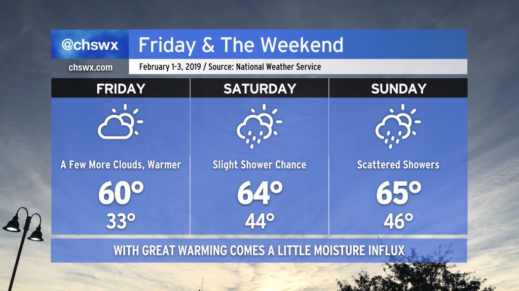
We will kick February off to a fairly warm start as temperatures rebound into the mid-60s for the weekend. With this, though, comes an elevated chance of rain as more moist air interacts with an upper-level disturbance. NWS notes that there is still some pretty sharp variability in the model guidance for the weekend, so there is the potential for changes to rain chances as we get into late Saturday and Sunday. With that in mind, don’t alter your plans, but be mindful of forecast updates as the weekend approaches. If outdoor activities are planned, be ready with a solid Plan B.
Even warmer to start the work week (but it’s still winter)

Looking ahead to the next seven days, we will find that temperatures continue to warm well into the upcoming work week. NWS is forecasting temperatures near 70 starting on Monday, with 70s appearing likely Tuesday and Wednesday. It will remain rather mild with the potential for scattered showers until a cold front approaches the area later next week. Said front will bring temperatures back down to earth a bit, so don’t get too comfortable with the 70s. As always at this range, the details are subject to change, so be sure to check back with forecast updates frequently.