Another warm, dry week ahead

Summer-like weather will continue this week. The heat will really turn on by the end of the week, as we look to flirt with mid-to-upper 90s temperatures across much of the area. Unfortunately, very little heat relief in the way of thunderstorms appears probable after Tuesday.
Why so hot?
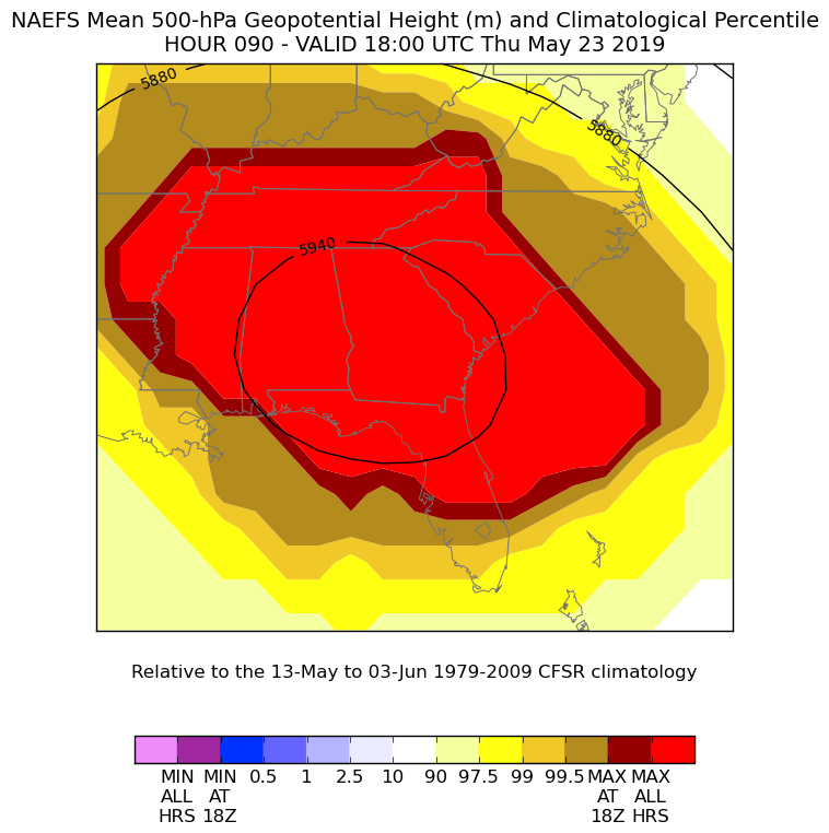
An anomalously strong (99th percentile!) blocking upper-level high will develop and take hold over Alabama and Georgia later this week. This high pressure aloft will put a lid on any thunderstorms that try to fire and will be the primary driver of our pattern into next week.
As the upper-level high becomes positioned over Alabama and Georgia, it will drive northwest flow into the Carolinas. This wind downsloping off the mountains will help compress the air further as it moves eastward. (As air becomes compressed, it warms.) Additionally, this trajectory will make it harder for the seabreeze to make a good inland push, which will allow us to bake even further. If there’s one good thing about northwest flow, though, it’s that drier air will tend to mix down and help keep dewpoints — and thus heat indices — in check at least a little bit. We may still see heat indices approaching 100° this weekend, though.
Records watch
Record highs, while not currently in the NWS forecast, could be challenged later this week and into the weekend. Here are a few of those records:
- May 24: 97° (1953)
- May 25: 97° (2000)
- May 26: 98° (1953)
The all-time record hottest May day is May 21, 1938, when temperatures at the airport climate site reached 99°. (Records date back to March 1938.)
Heat safety tips

While it’s not expected that heat index values will be reaching pre-July 1 advisory criteria of 105°, there is still the potential for vulnerable populations to be affected by several days of hot weather. Here are a few heat safety tips that will undoubtedly come in handy as the summer wears on.
- If at all possible, stay inside an air-conditioned building.
- Drink lots of (non-alcoholic) fluids. (Water works best.)
- Take frequent breaks, especially during the afternoon hours.
- Don’t leave children and pets in a parked car; the results can be fatal as temperatures within the car will climb rapidly. Cracking a window won’t do the trick, either. Check before you lock!
- Be wary of the signs of heat exhaustion and heat stroke.
Drought update

Moderate drought continues as of last Thursday’s Drought Monitor. We remain very far behind in rainfall for the year. Unlike last year, where we spent much of Spring in a drought before the skies opened up in May and basically erased it, we look to enter June at least maintaining moderate drought.
Monday and Tuesday offer the best rainfall chances as a little upper-level energy ripples through the area, which may help enhance seabreeze showers and thunderstorms each afternoon. However, with poor deep moisture return, this activity will be isolated at best. Those who get a storm may get a quick shot of a quarter-inch of rainfall, while the rest of us will be turning on the sprinklers again.
Tropics watch, preseason edition
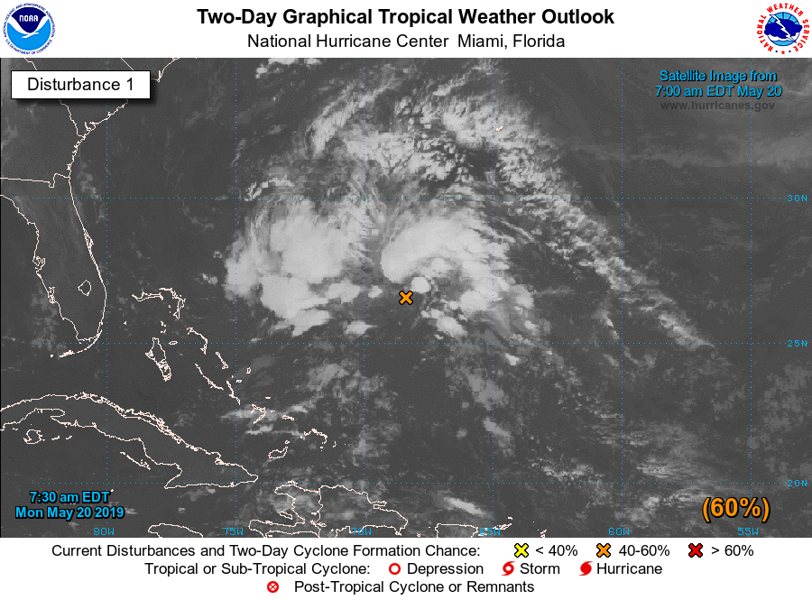
Hurricane season officially kicks off on June 1, but storms don’t care about calendars. In what is increasingly becoming an annual tradition in May, the National Hurricane Center is issuing special outlooks on an area of disturbed weather, dubbed Invest 90L, well off the coast of Florida and the Bahamas. This system currently has a 60% chance of attaining tropical or subtropical characteristics. If it should become named, it would be named Andrea. It could kick up a little surf, but otherwise is not a concern for our neck of the woods — just a quick reminder that hurricane season is indeed upon us.
Follow my Charleston Weather updates on Mastodon, Bluesky, Instagram, Facebook, or directly in a feed reader. Do you like what you see here? Please consider supporting my independent, hype-averse weather journalism and become a supporter on Patreon for a broader look at all things #chswx!