Another day, another record

We continue to rewrite the record books as a strong ridge of high pressure remains firmly entrenched over the Charleston area, with three straight days of 100° temperatures and counting. The streak may continue for one more day, followed by a gradual falloff of temperatures (and a small increase in shower and thunderstorm chances) as we get into the weekend.
Another new record high temperature for May

The full-blown rewrite of the record books continues this week. At 2:37 PM, the thermometer at Charleston International Airport reached 101° for the first time since June 22, 2011, setting a new record for warmest May temperature since records began in 1937. This breaks the record of 100° set on May 26 and tied yesterday. The daily high temperature record of 98° was also broken, making it four straight days with record highs being tied or broken at the airport. Finally, our current streak of three days of 100°+ temperatures is the longest since June 19-21, 2011. If we achieve 100° again on Wednesday, which is forecasted by the National Weather Service, 2019 would join 1986 as the only other year on record when 100° was achieved four straight days (this happened twice in 1986, including a record 7-day streak from July 8-14).
Sadly, the sensor in downtown Charleston is down for unspecified reasons. We in the #chswx community were hoping to get some data from it today, but it looks like that has not been able to happen yet. It would be mighty interesting to know what official observations look like downtown versus the airport.
Why no heat advisories?
For all this talk about record heat, you would think that we would hear more about Heat Advisories being issued — but aside from Sunday, that has not been the case. Here’s what’s up.
The National Weather Service issues heat advisories based on heat index values and the time of year they occur. Before July 1, when heat indices are forecast to meet or exceed 105° for two hours, the National Weather Service will issue a heat advisory. After July 1, the heat index threshold is 110° or higher.
During this event, the air has been remarkably dry. Deep northwest flow around a stacked high pressure system causes downslope trajectories from the mountains. This sinking effect, working in tandem with the deep-layered high pressure system over the region, helps to dry the air out and warm it via compression. The National Weather Service in Columbia diagrammed it nicely on Twitter:
Thus, without significant moisture in the air, the relative humidity plummets, keeping heat indices much closer to the actual air temperature. Since the air temperature has been below 105°, and there’s not been appreciable humidity to make the heat index jump much higher, heat advisories have largely not been needed. The exception to this was Sunday, when the seabreeze made a decent inland push, allowing for more moist Atlantic air to make it inland. (As the seabreeze pushes west, dewpoints surge behind it, spiking the heat index for a brief period before the air has a chance to cool off some.)
The lack of a heat advisory doesn’t necessarily mean it’s not dangerously hot — these kinds of temperatures can still be harmful to the elderly and other sensitive groups. Be alert to the signs of heat stroke — headache, no sweating, hot skin, nausea, vomiting, and/or loss of consciousness — and seek medical attention immediately.
Drought watch

The drought continues, with eight straight days of no precipitation at the airport through May 28. There have been 21 days with no precipitation recorded at all so far this May. Thanks to a well-placed downpour on May 12, in which the airport recorded 3/4″ of rain, the monthly total stands at 1.39″, which is good for 14th driest on record. Meanwhile at Downtown Charleston, with the caveat of not having reported for a few days, stands at 0.26″ for the month of May, good for fifth driest on record there.
An exceptionally dry start to the year overall
With 7.46″ for the year so far at the airport, 2019 is the driest start to a year (through May 28) on record. The next driest start came in 1985 with 8.15″ of rain through May 28.
At Downtown Charleston, 5.08″ to start the year is good for second driest on record. Only 1911 was drier at 4.81″. (Records at downtown Charleston date back to 1893.)
Next Drought Monitor: Thursday
We’ll get an updated Drought Monitor on Thursday. It will be interesting to see if the drought level is upgraded for at least part of the Lowcountry. Lawns are a decent proxy for this, and with several crunchy, dry patches developing in many yards, it is beginning to look like a little more of a severe drought. Stay tuned.
Changes in store as we head into the weekend
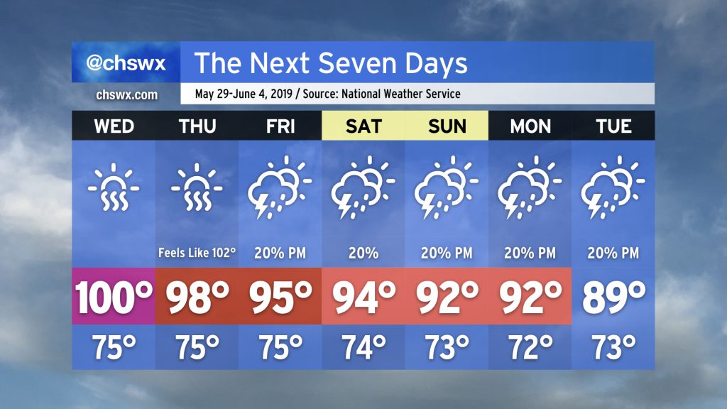
It looks like we will see one more 100° day on Wednesday as the ridge of high pressure aloft maintains itself for one more day. Thereafter, we will begin to see upper level energy start to push this ridge further southward. Thursday will be a touch cooler as far as air temperatures go, but slightly better humidity levels will drive the heat index over 100°. A gradual cooldown continues on Friday as the ridge is suppressed further southward; some upper-level energy looks to ripple through late Friday into Saturday as well, which may generate some isolated showers and thunderstorms. Overall, expect temperatures to be on the decline (though still above normal) as we begin June.
There will be shower and thunderstorm chances each afternoon along and ahead of the seabreeze, but a widespread rain event just isn’t in the cards. Some will get lucky with a free lawn watering; many will not. Overall, expect the drought to persist for the foreseeable future.
Reminder: Hurricane season opens on June 1
The Atlantic hurricane season kicks off on June 1. The South Carolina Emergency Management Division has marked this week as Hurricane Preparedness Week. Use this time to learn your evacuation zones, put together a basic disaster kit, and evaluate your home, including insurance, for resilience to tropical weather. (It is much less stressful to have this stuff taken care of now than when a storm is barreling down on us!)
Remember, it only takes one storm for it to be an active season. Getting ready now will save you a lot of heartache down the road.
Follow my Charleston Weather updates on Mastodon, Bluesky, Instagram, Facebook, or directly in a feed reader. Do you like what you see here? Please consider supporting my independent, hype-averse weather journalism and become a supporter on Patreon for a broader look at all things #chswx!