Tropical update: Jerry is named
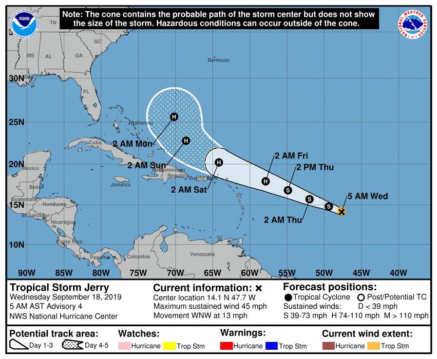
Tropical Depression Ten strengthened overnight, having reached Tropical Storm status and the threshold to receive a name. The name most of us thought this system would get was Imelda, but a tropical depression formed quickly near the Gulf Coast yesterday and was named within an hour’s time. Imelda is already inland, so we are now watching Tropical Storm Jerry as it churns in the Atlantic, 960 miles east of the Leeward Islands (and a lot farther than that from Charleston!)
Things to watch with Jerry
Guidance for Jerry is generally split into two camps. The first, larger camp takes a weaker Jerry west-northwest, with a northward turn indicated by late this weekend. (This is the National Hurricane Center’s thinking as well, by the way.)
The second camp, though, would take a stronger Jerry further south and west. Levi Cowan of Tropical Tidbits fame explains the technical reasons why this would be:
The non-nerdy explanation: The stronger Jerry gets, the taller it becomes. The taller it becomes, the more likely it would be influenced by high pressure further up in the atmosphere to take a more southerly course.
In the end, Jerry’s intensity will want to be watched closely over the next few days. An upward trend in strength sooner could be the difference between a largely harmless recurvature (with the exception of Bermuda) and a path that will warrant a heightened level of attention. And while NHC track forecasts are friggin’ amazing, intensity forecasts still have a ways to go. There’s just a lot more we don’t know about how and why tropical cyclones strengthen or weaken the way they do.
So, Jerry bears watching, but not at the expense of a beautiful few days teed up for the Lowcountry in the wake of the first legitimate cold front of the season. We have a long way to go before this becomes a Charleston problem, if it even gets to that point at all.
What to do today
- Check in with a forecast update later today.
- If you feel so moved, check your disaster kit.
- Enjoy the beautiful weather! (Seriously, it’s going to be freaking amazing.)
Next update
I plan to do a quick update on how things are going with Jerry on a daily basis, usually in the mornings. If things change a little more quickly, I’ll update sooner.
As always, the National Hurricane Center will be publishing advisories every six hours: 5am, 11am, 5pm, 11pm. So, if you want the blow-by-blow of Jerry’s evolution, I recommend getting it straight from the source.
Follow my Charleston Weather updates on Mastodon, Bluesky, Instagram, Facebook, or directly in a feed reader. Do you like what you see here? Please consider supporting my independent, hype-averse weather journalism and become a supporter on Patreon for a broader look at all things #chswx!