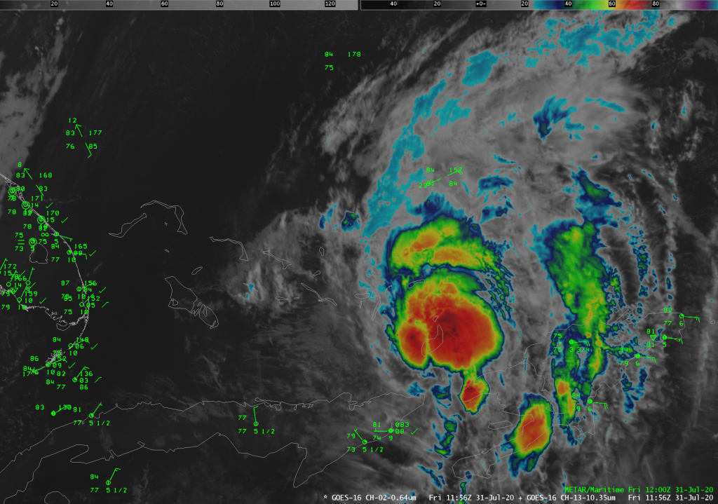
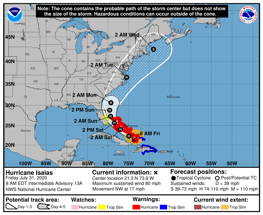
Isaias is a hurricane; track forecast largely unchanged

It’s not the most picturesque hurricane on record, but it will do: Hurricane Isaias, which was upgraded after Hurricane Hunters found winds near 80 MPH last night, is now churning through the Bahamas this morning. Isaias remains a Category 1 storm as of this morning with 80 MPH winds, and is moving NW at 17 MPH. It is expected to strengthen to a Category 2 storm with max winds of 100 MPH before weakening as it curves up the US coast this weekend.
Where’s it going?

Since 5PM yesterday, Isaias’s forecast track has been relatively stable: cutting a path through the Bahamas before recurving parallel to the Florida, GA, and SC coastline, followed by a landfall somewhere in eastern NC late Monday/early Tuesday. Timing for adverse weather in the Lowcountry remains roughly between Sunday evening through late Monday/early Tuesday.
The track of the storm will be governed by a couple key steering components: a trough of low pressure moving into the eastern half of the country, and a weakening Bermuda high to the east. Isaias will thread the needle between these two features as it navigates its way up the Eastern Seaboard early next week.
The impacts picture begins to take shape, but is still highly uncertain
We are starting to get a better idea of the general impacts we may see from Isaias. It is still too early to tell how strong of a storm Isaias will be for us, though. Once again, we will be contending with a storm where a 20-mile wobble left or right makes a big difference as far as what we might feel here. But, we can still start to make out some details in the forecast picture now:
- Coastal flooding may become a concern Sunday night into Monday as Isaias approaches from the south and winds are more onshore. Again, a lot depends on how close the storm is; expect greater coastal flooding/storm surge impact if the storm’s center hugs the coast more closely.
- Rip currents and rough surf are typical of hurricanes passing hundreds of miles off our coast, and Isaias will be no exception.
- Beach erosion may occur, especially if the center gets closer and stronger winds arrive at the beaches as a result.
- Wind and rain are the biggest question marks right now, as they will be the most dependent on the center’s location as it passes us by. Best chances for these impacts will be near the coast, especially as we remain on the western (weaker) side of the circulation. These effects would spread further inland, of course, if the storm’s center passes closer to us.
What to do today
- Work on your hurricane preparations. This isn’t to say that it’s time to board up or anything, but make sure you are prepared for power outages and other disruptions to daily life. Make sure you have hand sanitizer and masks on hand, too — we are still in a pandemic, after all. Here are some tips.
- Know your evacuation zone. While unlikely, we have seen evacuations called for storms like these before. We do remain in the cone of uncertainty, which means that a direct landfall, while highly unlikely, is not off the table. Use the SCEMD Zone Finder to locate your evacuation zone. Know where you will go if asked to evacuate — shelter space is going to be at a premium due to social distancing requirements.
- Keep an eye on official forecasts and leave the models alone. We are at that point in preparing for the storm where the track is being fine-tuned, and models will have a tendency to go back and forth a little bit. Use the National Hurricane Center forecasts to make your decisions — weather models are for guidance only. NHC forecasters outforecast the models more often than not. Trust their expertise.
I’ll have updates on Twitter throughout the day, and will do another post if things should change drastically. Stay tuned.
Follow my Charleston Weather updates on Mastodon, Bluesky, Instagram, Facebook, or directly in a feed reader. Do you like what you see here? Please consider supporting my independent, hype-averse weather journalism and become a supporter on Patreon for a broader look at all things #chswx!