The week ahead: A brief respite in humidity, but rain resumes
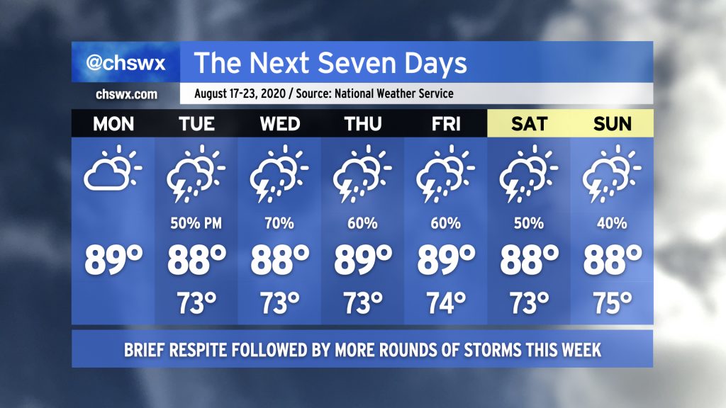
After a brief respite from suffocating humidity today — the overnight temperature dropped to 69°, according to NWS, the coolest since June 20’s low of 67° — we will see rain chances return to the forecast as the upper trough which has kept things quite unsettled remains in place for the next few days. Brief bouts of heavy rain will be possible once again, but it won’t rain all the time or even every day at one particular spot. As we get into the weekend, Atlantic high pressure looks to build back into the area, which will help tamp down the overall coverage of storms (and begin sending temperatures back upwards a bit).
The tropics are waking back up
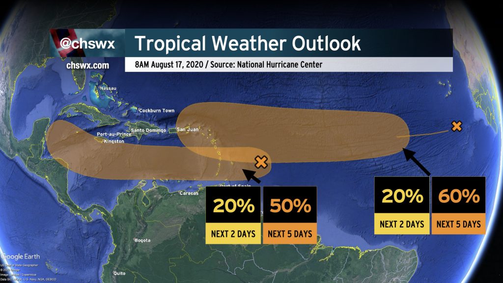
Expectedly, the tropical Atlantic is beginning to wake up as we approach the peak of the season and atmospheric conditions become more favorable for development. The National Hurricane Center is watching two areas for possible development over the next few days. The first, near the Lesser Antilles, will have a shot at becoming a depression later this week as it moves through the Caribbean. The second, about a day or two removed from the coast of Africa, looks likely to become a depression later this week as it moves across the Atlantic. There are no imminent tropical threats to the Lowcountry, but we’ll want to monitor these as they make their trek westward. If there is one I’d be particularly keen on keeping an eye on, it’d be the second disturbance closer to the Cabo Verde Islands.
The peak of a busy season awaits
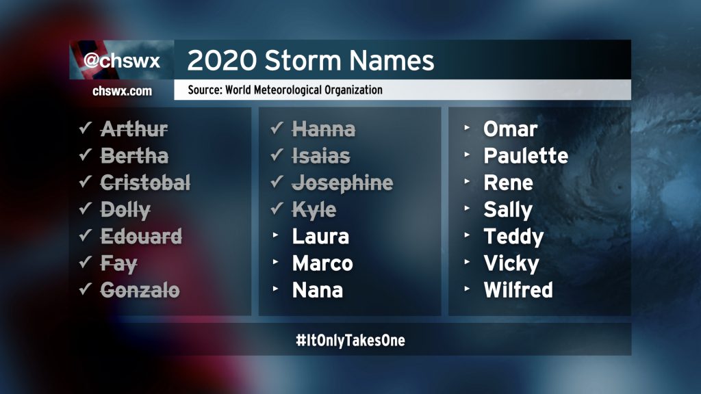
There are no imminent concerns for the Lowcountry, but get ready for what could be a busy few weeks of watching tropical systems in the Atlantic. We are still out-pacing 2005 as far as named storms go, but to this point, these storms have not been exceptionally strong. (We are just better at finding tropical cyclones from satellite nowadays, among other reasons.) However, as the Cabo Verde season gets underway, the risk for stronger hurricanes will increase. Climatologically speaking, the Atlantic hurricane season peaks on September 10.
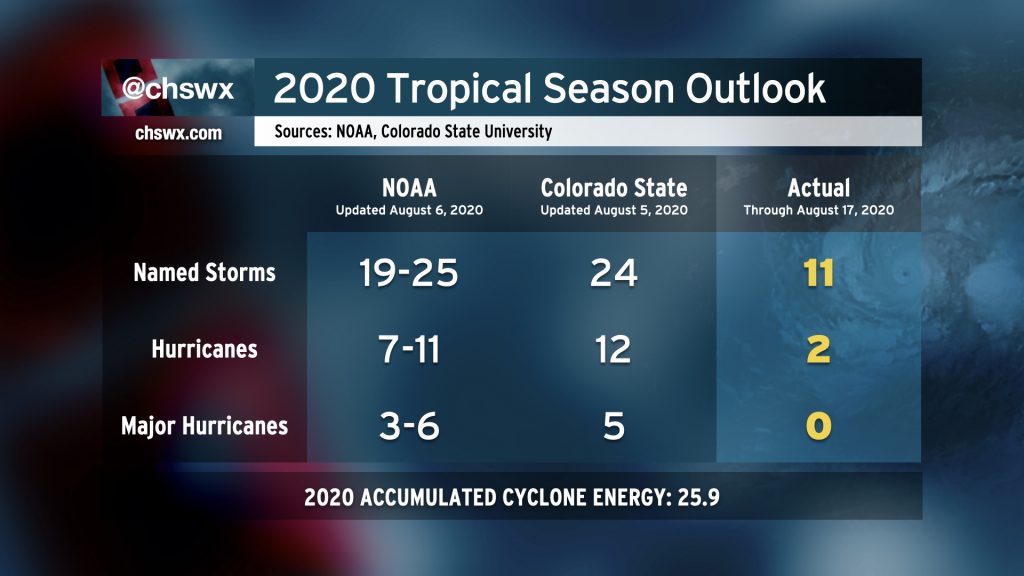
Our very busy tropical season looks to continue, with NOAA seasonal forecasters predicting between 19-25 named storms, 7-11 hurricanes, and 3-6 major hurricanes. Colorado State is predicting 24 named storms, 12 hurricanes, and 5 major hurricanes. If these forecasts pan out, we’ll end up dipping into the Greek alphabet for names.
Remember: These seasonal forecasts do not imply that every storm will be a threat to us, but rather are an overall look at the Atlantic basin as a whole (which is huge!). However, they do help to underscore the importance of being prepared for storms. The best day to do that is today, when there are no imminent threats. Give the hurricane kit a look as we head into the peak of the season, refresh your memory on your evacuation zone, and then hope that you don’t have to use any of it. 🙂
Follow my Charleston Weather updates on Mastodon, Bluesky, Instagram, Facebook, or directly in a feed reader. Do you like what you see here? Please consider supporting my independent, hype-averse weather journalism and become a supporter on Patreon for a broader look at all things #chswx!