A windy, rainy start to a chilly week
We’ll get this week off to a rainy and windy start as the storm system which rained on us for a fair bit of today moves through the area on Monday, ushering in the coldest air of the season in its wake.
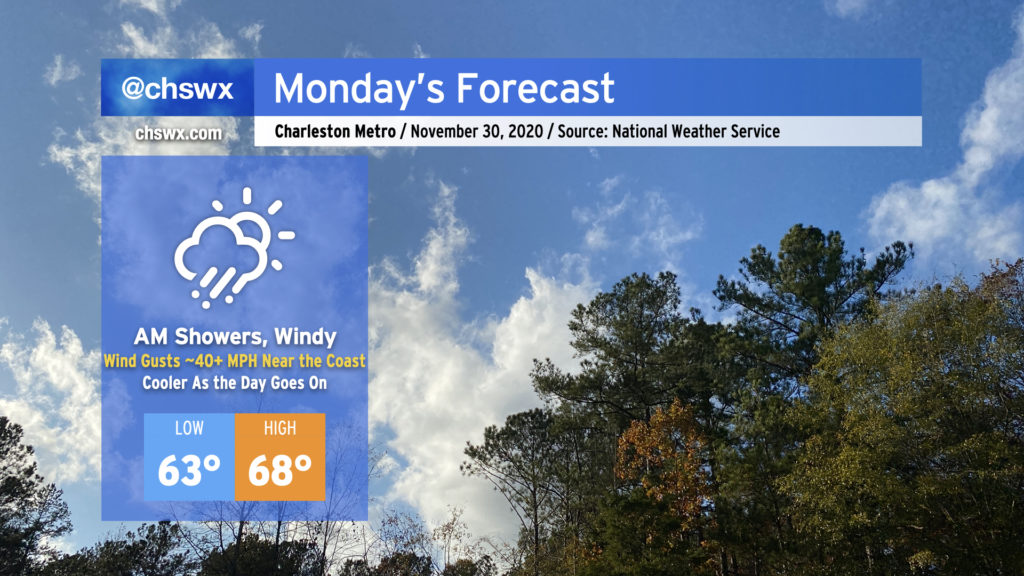
Monday’s forecast
It’s going to be fairly windy particularly tomorrow morning as the cold front sweeps through. Gusts near the coast could reach 40 MPH, and that has prompted the National Weather Service to issue a wind advisory from 6am to noon. Be ready to take it easy if the bridges are involved in your morning commute. Elsewhere, winds will still be gusty, perhaps to 30 MPH at times as the front moves by and high pressure takes hold in its wake.
Temperatures will top out in the upper 60s to around 70° early in the day prior to frontal passage. Temperatures will steadily drop into the low 60s during the course of the afternoon.
Showers and thunderstorms remain possible ahead of the front. There will be plenty of wind shear, but probably not enough instability for severe thunderstorms. Even still, don’t be surprised if there is a warning or two for higher gusts within thunderstorms if they become strong enough. The window for any severe weather closes by noon, and likely a lot sooner.
The week ahead: Coldest air of the season
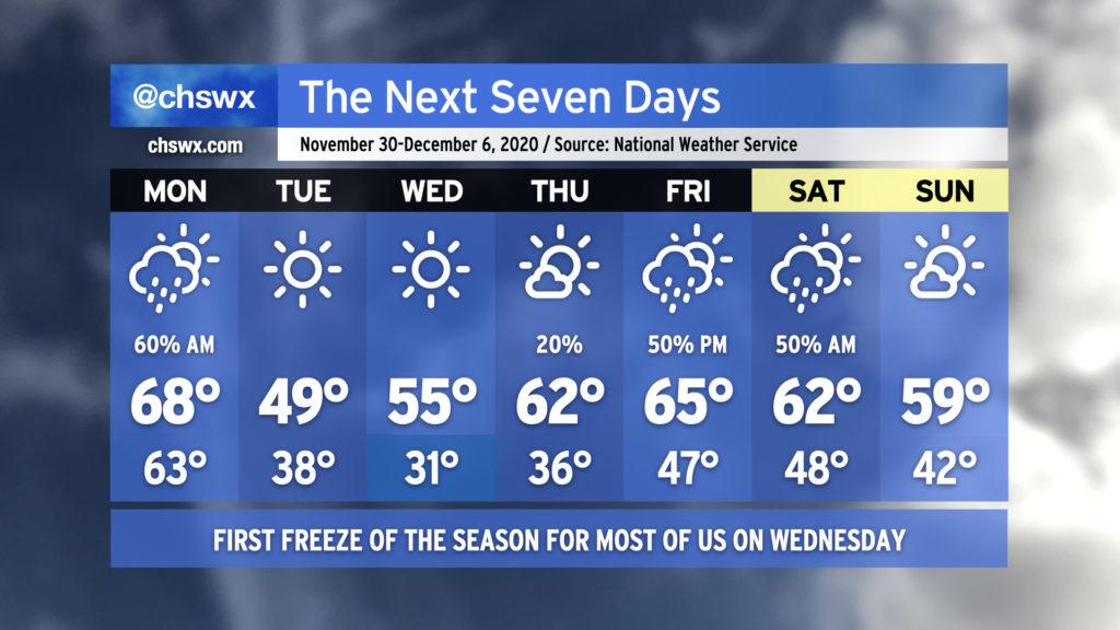
I hope you’ve got your heavier jackets ready, because you’re going to need them for at least the first part of this week. We’ll start Tuesday morning with air temperatures in the 30s and wind chills in the mid-20s as winds remain elevated. Highs will struggle to reach 50° on Tuesday as cool air continues to spill into the area as high pressure builds in.
First freeze for many of us is likely overnight Tuesday into Wednesday morning
Expect many spots to reach freezing, perhaps for a few hours particularly inland, overnight Tuesday into Wednesday morning. Winds will still be elevated, and the resulting wind chills will make temperatures feel closer to the upper 20s at times. A freeze is not expected in downtown Charleston and along the barrier islands right now, but it will be close, and the resulting wind chill will still make it feel much colder.
Frost and freeze advisories from the National Weather Service end with the end of the growing season on December 1, so there will be no alerts for Tuesday night into Wednesday morning. Still, if you have sensitive plants, take care to protect them from freezing conditions Tuesday evening before you head to bed.
While we are running as many as two weeks behind the median first freeze date for inland locations, we’re pretty close to schedule here in the Charleston metro area, with a median first freeze date of November 29th.
Gradual warming trend for the rest of the week
It looks like Wednesday morning will be the bottom-out point for temperatures, as we’ll see a warming trend starting Wednesday afternoon as the progressive upper-level pattern keeps the surface high moving fairly quickly. Now, granted, a high of 55° on Wednesday afternoon is still pretty chilly, but it’s not the 40s.
Once high pressure slips to our north and east, temperatures warm back to the 60s for Thursday afternoon. This gives way to another storm system heading northward across the Eastern Seaboard for Friday, bringing rain chances back into the picture for Friday into Saturday morning. Another front comes through Saturday with this storm system, leaving Sunday a little cooler and drier, but not as cold as we’re seeing to start the week.
Follow my Charleston Weather updates on Mastodon, Bluesky, Instagram, Facebook, or directly in a feed reader. Do you like what you see here? Please consider supporting my independent, hype-averse weather journalism and become a supporter on Patreon for a broader look at all things #chswx!