Good-looking Fourth of July weekend in store as we watch Elsa
Rainfall this evening has thankfully been a little tamer than forecast, with the bulk of the heaviest rain developing just offshore this afternoon. We will still see a few showers later this evening and overnight, particularly as the cold front currently draped across the Midlands sinks into the area.
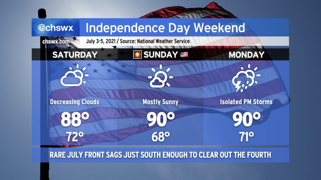
Said front will move well south of the area by tomorrow morning, and skies will clear in its wake, yielding what looks to be an excellent Fourth of July weekend. Temperatures will run in the upper 80s to around 90° each day through Monday, with mostly sunny skies for Saturday and Sunday. We may see a couple storms pop on the seabreeze on Monday, but most of us will stay dry. Then after that, we turn to Elsa.
Watching Elsa
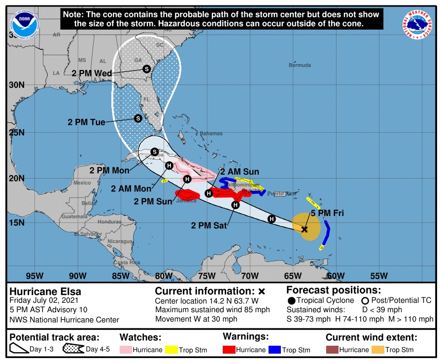
Hurricane Elsa — yes, a hurricane — has exceeded intensity expectations throughout the day as it heads westward at 30 MPH into the Caribbean. Hurricane warnings are up for Jamaica and the southern coast of Hispaniola, with a Hurricane Watch now up on the eastern side of Cuba. The National Hurricane Center forecast calls for the storm to pass by Hispaniola on Saturday, reaching Cuba by Sunday afternoon. Elsa’s interaction with such mountainous terrain should weaken the storm to a tropical storm by the time it reaches the Florida Straits.
From there, things get a little more uncertain. The key will be the strength of high pressure, and this is a big point of contention between the global models. The GFS ensemble is way west, taking the storm up into Georgia and through the Midlands, while the EPS (European) ensemble is way east, with many members favoring a recurvature out to sea.
As for the NHC forecast, we are within the cone of uncertainty as we get into Wednesday, with a low — but non-zero — probability of tropical storm-force winds beginning then. Given the variability and spread in the models, this isn’t terribly concerning at this point, but is obviously something that we should keep a close eye on throughout the weekend for potential impacts on our weather in the middle of next week. What those impacts are will be highly predicated on where Elsa ultimately goes. A more inland track certainly brings more rain and even some severe weather concerns, while a track that stays east of us gives us less of an impact overall (if any, depending on how far to the east it gets).
For now, we in #chswx will watch it, and I’ll encourage you to do the same. Just don’t forget to enjoy your Fourth.
Follow my Charleston Weather updates on Mastodon, Bluesky, Instagram, Facebook, or directly in a feed reader. Do you like what you see here? Please consider supporting my independent, hype-averse weather journalism and become a supporter on Patreon for a broader look at all things #chswx!