Cold front to bring storms through the area Friday, but clears us out nicely for the Fourth
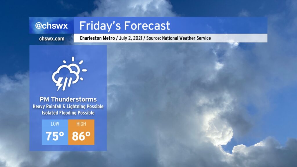
After a couple days in a classic summertime Bermuda High setup, we’ll see that high continue to retrograde eastward, giving way to a cold front sinking south from the Ohio Valley. Said front will run into an incredibly juicy airmass courtesy of a robust moisture tap from the Gulf, and help to ignite numerous showers and thunderstorms in the afternoon. This will have the effect of holding temperatures down into the mid-80s.
Flooding potential Friday afternoon
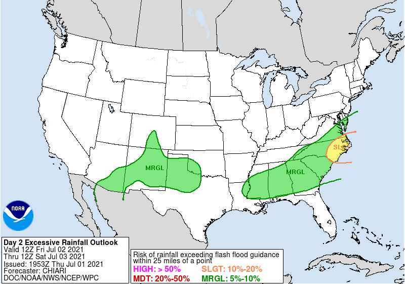
Given such stout atmospheric moisture in place — some models easily indicate precipitable water values over 2.2” (anything over 2” is pretty juiced) — there certainly will be a concern for isolated pockets of flooding in the usual spots, especially where training of thunderstorms develop. The Weather Prediction Center has outlined the area in a marginal risk for flash flooding for Friday; as details become more apparent, this outlook could be upgraded.
Another trend to watch will be the position of the seabreeze circulation and where it ultimately sets up across the metro area. There are signs in guidance that it may get a little pinned up near the coast for a time. If this happens, and outflow boundaries from upstream storms make it south into the area, the resulting boundary collision could cause some flooding in downtown Charleston due to very heavy rain.
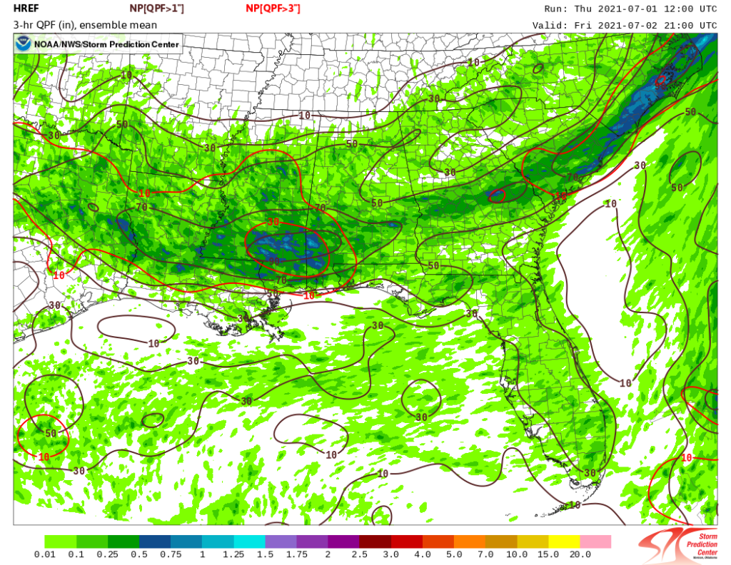
There is support for this possibility in the high-resolution model ensemble (pictured above), with a precipitation maximum noted near the coast and a swath of pretty good probabilities of over an inch of rain in the evening. The ensemble is pinging on probabilities of 3” in 3 hours across the Lowcountry, as well, which certainly bears watching for a more robust rainfall and flooding threat. Finally, high tide will peak a little around 3:15 PM on Friday. With any luck, the heaviest rain will miss this window (and current indications are that it will), but we will watch it.
As a reminder: Predictability of such events is very tricky, even a day out. Subtle shifts in position or timing can yield dramatically different outcomes. However, the signals are there, and so we’ll be watching closely.
Improvement heading into Independence Day weekend
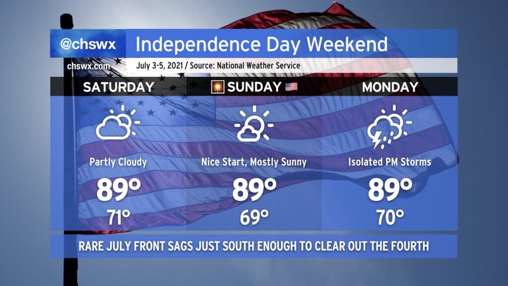
The good news in all of this, though, is that the front is expected to sag far enough south of the area that we should have a pretty good Fourth of July weekend. Saturday could feature some morning showers as the front departs, but otherwise clouds should be clearing out a bit as we head to a pretty decent-looking day in the upper 80s to around 90°.
The Fourth looks excellent, with a little bit of drier air allowing some upper 60s to sneak southward into the area away from the coast in the morning. Clouds should be few and far between, and there are no concerns for professional fireworks displays. Highs top out once again in the upper 80s to around 90°.
Monday should be mostly dry across the area, but there will be a slight chance of thunderstorms in the afternoon and evening with the seabreeze. Highs again top out near 90°.
Watching Elsa
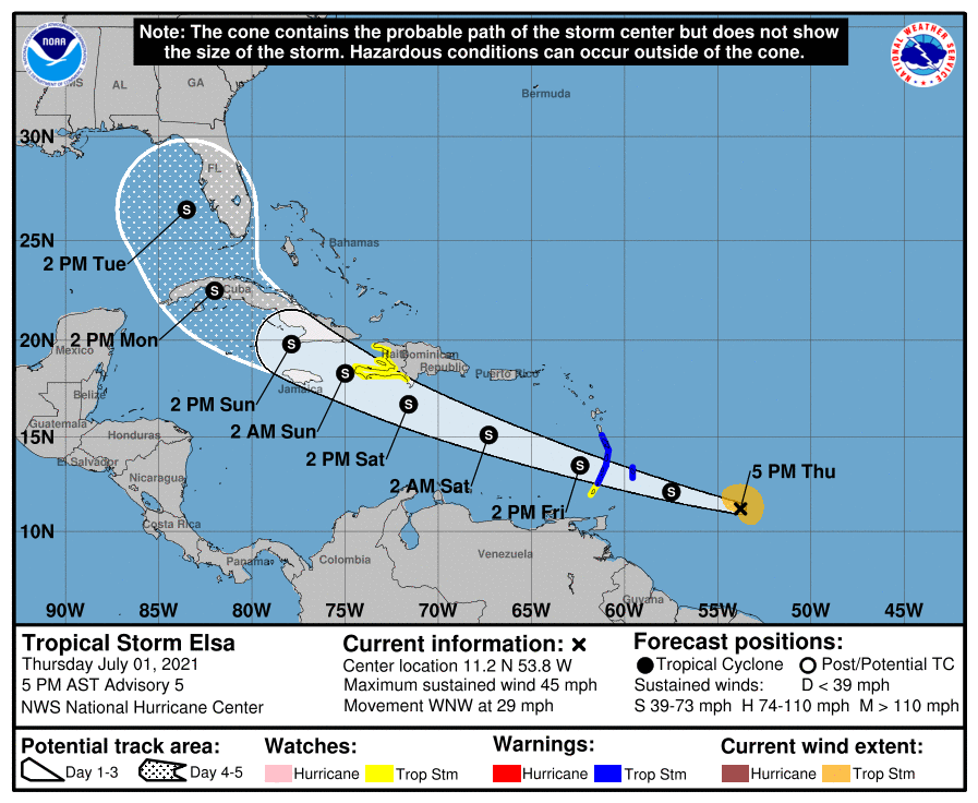
If all the Frozen memes on the news, weather Twitter, etc. haven’t tipped you off, there is a new tropical storm in the Atlantic. Its name is Elsa, and it has the dubious distinction of beating last year’s Edouard for being the earliest “E” storm on record. (I’d rather not pace ahead of 2020 in any hurricane season if I can help it, but here we are.)
Elsa is an interesting storm to watch with a lot of uncertainty especially toward the end of its track. Storms don’t really get going in this part of the Atlantic so soon in the season, so there isn’t much history to go by. The National Hurricane Center forecast right now keeps it at tropical storm strength as it races WNW across the Lesser Antilles tonight and tomorrow. The forward speed will likely hinder some intensification. There’s also the question of how much Elsa will interact with Hispaniola as we get further into the weekend, which will certainly have impacts on the intensity and track forecasts.
With that in mind, the track forecast from NHC does bring it along Florida’s Gulf Coast as a tropical storm by Tuesday. Model solutions run the gamut between the NHC forecast and a total recurvature to sea, which is to say that confidence in the long-term track forecast is low. Still, we’ll want to keep an eye on this for possible impacts in the Carolinas in the middle of next week. Stay tuned for now; we’ll watch the trends and just take it from there.
Follow my Charleston Weather updates on Mastodon, Bluesky, Instagram, Facebook, or directly in a feed reader. Do you like what you see here? Please consider supporting my independent, hype-averse weather journalism and become a supporter on Patreon for a broader look at all things #chswx!